Mahatma Gandhi Marine National Park (M.G.M.N.P) | |
---|---|
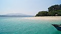
![]() This is the Mahatma Gandhi Marine National Park near Port Blair, Andaman Islands. Its popularly known as "Jolly buoy" islands. | |
![]() | |
Location | Andaman Islands, India |
Nearest city | Wandur |
Area | 281.5 km2 (108.7 sq mi) |
Established | 1983 |
Nickname: North Mahatma Gandhi Islands | |
---|---|
Geography | |
Location | Bay of Bengal |
Coordinates | 11°32′N92°36′E / 11.53°N 92.60°E |
Archipelago | Andaman Islands |
Adjacent to | Indian Ocean |
Total islands | 17 |
Major islands |
|
Area | 29.043 km2 (11.214 sq mi)land area |
Highest elevation | 78 m (256 ft) [1] |
Highest point | Tarmugli Island |
Administration | |
District | South Andaman |
Island group | Andaman Islands |
Island sub-group | Rutland Archipelago |
Tehsil | Port Blair Tehsil |
Largest settlement | Jolly Buoy Beach |
Demographics | |
Population | 0 (2011) |
Additional information | |
Time zone | |
PIN | 744103 [2] |
Telephone code | 031927 [3] |
Official website | www |
Census Code | 35.639.0004 |
Official Languages | Hindi, English |
Mahatma Gandhi Marine National Park is a national park in India, near Wandoor on the Andaman Islands. It belongs to the South Andaman administrative district, part of the Indian union territory of the Andaman and Nicobar Islands. [4]
The park was created on 24 May 1983 under the Wildlife Protection Act of 1972 protect marine life such as the corals and nesting sea turtles prevalent in the area. It was placed under the protection of the Chief Wildlife Warden of the forest department of the Andaman and Nicobar Islands and it is open creeks running through the park area were a special attraction. [5]
There are 2 major island groups in the park: the Labyrinth Islands and the Twin Islands. The islands are situated 16 km (10 mi) south from Port Blair. The marine park covers 281.5 km2 made up of 17 islands and the open sea creeks running through the area. There is a chance for ecotourism on the islands of Jolly Buoy and Red Skin. [6] [7] [8] The islands belong to the Rutland Archipelago and are located between Rutland Island and South Andaman Island.
Most of the coral reefs in the park are fringing reefs. The type and composition of vegetation vary from island to island. Most notably there you can see a difference between the tourist islands which suffer more anthropocentric change and others which do not. There are also some islands more isolated or protected from the effects of weather in the Bay of Bengal. Tarmugli, the largest island, is covered with thick mangrove vegetation, sand covered beaches, uprooted trees and sheet rocks. [9] Twin Islands are an important breeding ground for turtles within the park.
The national park hosts an amazing variety of wildlife and plant species. The island has some 200 species of Corals of which some are Staghorn coral, Mushroom coral, Plate coral, Brain coral, etc and Acropora, Pacillopora, Montipora, Fungia, Leptoseris, Forties, gorgonians and tubipora are the important corals of the area. The coral reefs supports a wide variety of colourful fishes. Some fishes are Anglefish, Lionfish, Grouper fish, clown fish, sergeon fish, butterfly fish, bat fish, parrot fish, hammer-head shark, [[White tip shark][, manta-ray and blue finack. Ferries are often chased by playful dolphins. As we move towards land the we come into the fascinating world of rainforest and mangrove. Mangrove forest provide home to various species like snakes, crab, saltwater crocodile, and waterfowls. One can see giant robber crab, which climbs up coconut palms and break the hard shell of it fruit. The forest is home to 40 odd species of snakes including Andaman pit viper, Andaman cobra, other reptiles include hawksbill turtle, common water monitor, saltwater crocodile. Birds include White -bellied sea eagle, parakeet, dove. Mammals found here are wild pig, civet, flying fox. Flora here includes Dipterocarpus turbinatus, Andaman Red wood, bamboo and various other plants including orchids.
Mahatma Gandhi Marine National Park has some 20 islands and rocks.
Politically, all islands are part of Port Blair Taluk. [10] Ferries are available from Wandoor village. Only 2 islands that allow visitors are Jolly Bouy island and Redskin Island
The islands are on uninhabited land, but there is a population of 6237 living in 6 adjacent villages (mainly Manglutan and Wandoor)
The Andaman and Nicobar Islands is a union territory of India comprising 572 islands, of which only 38 are inhabited. The islands are grouped into two main clusters: the northern Andaman Islands and the southern Nicobar Islands, separated by a 150 km (93 mi) wide channel. The capital and largest city of the territory, Port Blair, is located approximately 1,190 km (740 mi) from Chennai and 1,255 km (780 mi) from Kolkata in mainland India. The islands are situated between the Bay of Bengal to the west and the Andaman Sea to the east. The northernmost point is 901 km (560 mi) from the mouth of the Hooghly River. Indira Point, located at 6°45'10″N and 93°49'36″E on the southern tip of Great Nicobar, is the southernmost point of India.
The Andaman Sea is a marginal sea of the northeastern Indian Ocean bounded by the coastlines of Myanmar and Thailand along the Gulf of Martaban and the west side of the Malay Peninsula, and separated from the Bay of Bengal to its west by the Andaman Islands and the Nicobar Islands. Its southern end is at Breueh Island just north of Sumatra, with the Strait of Malacca further southeast.
Port Blair, officially named as Sri Vijaya Puram, is the capital city of the Andaman and Nicobar Islands, a union territory of India in the Bay of Bengal. It is also the local administrative sub-division (tehsil) of the islands, the headquarters for the district of South Andaman, and the territory's only notified town.
Little Andaman Island is the fourth largest of the Andaman Islands of India with an area of 707 km2, lying at the southern end of the archipelago. It belongs to the South Andaman administrative district, part of the Indian union territory of Andaman and Nicobar Islands. It lies 88 km (55 mi) south of Port Blair, the capital of Andaman and Nicobar Islands.
South Sentinel Island is one of the Andaman Islands in the Bay of Bengal. It is 1.6 km (1 mi) long northeast to southwest and up to 1 km wide. At only 1.61 km2, it is much smaller than its counterpart North Sentinel Island and is currently uninhabited. The island belongs to the Port Blair tehsil in the South Andaman administrative district, part of the Indian union territory of Andaman and Nicobar Islands, neighbouring North Sentinel Island.
Middle Button Island National Park is an Indian national park located in the Andaman and Nicobar Islands. The park was created in 1979 and is situated about 200 km (124 mi) northeast of Port Blair, capital of the island group. The total area that the national park covers is about 64 km2 (25 sq mi). Along with the neighbouring islands of North Button and South Button, both also national parks, it forms part of the Rani Jhansi Marine National Park off the coast of South Andaman Island.
South Button Island National Park is a national park located in the Andaman and Nicobar Islands off the coast of India. The total area of this protected island is about 5 km2 (2 sq mi), which makes it the smallest national park in India. Along with the neighbouring islands of North Button and Middle Button, both also national parks, it forms part of the Rani Jhansi Marine National Park off the coast of South Andaman Island.
Marine National Park in the Gulf of Kutch is situated on the southern shore of the Gulf of Kutch in the Devbhumi Dwarka district of Gujarat state, India. In 1980, an area of 270 km2 from Okha to Jodiya was declared Marine Sanctuary. Later, in 1982, a core area of 110 km2 was declared Marine National Park under the provisions of the Wildlife (protection) Act, 1972 of India. There are 42 islands on the Jamnagar coast in the Marine National Park, most of them surrounded by reefs. The best-known island is Pirotan. The park protects two major ecosystems, corals and mangroves.
Rani Jhansi Marine National Park is located in the Andaman and Nicobar Islands in the Bay of Bengal. It was founded in 1996, and covers 256 km2. It commemorates Lakshmibai, the Rani of Jhansi (1828-58). It is located in the Ritchie's Archipelago and is about 30 km from Port Blair. It contains coral reefs and mangrove forests. The biggest attraction in the park is a fruit-eating bat. It plays a major role in the ecosystem, because it pollinates plants and scatters seeds.
Madagascar mangroves are a coastal ecoregion in the mangrove forest biome found on the west coast of Madagascar. They are included in the WWF's Global 200 list of most outstanding ecoregions.
The Andaman Nicobar Environment Team (ANET) field station is a multidisciplinary research and intervention facility focusing on environmental sustainability, located at North Wandoor, South Andaman, and the only research base of its kind in the Andaman and Nicobar Islands. With its mission to develop effective conservation strategies and community wellbeing based on a sound understanding of the islands' diverse social-ecological systems, ANET aims to contribute to resolving environmental and societal challenges in the islands through independent interventions, inter-organisational collaborations and the facilitation of engagements by organisations with similar visions and goals. ANET is owned and operated by Dakshin Foundation, Bangalore.
The Lampi Island Marine National Park is a marine national park in Myanmar covering 79.09 sq mi (204.8 km2). It was established in 1996. It encompasses Lanbi Island and several smaller islands in the Mergui Archipelago, comprising coral reefs, seagrass beds, mangroves, sand dunes and tropical evergreen forest up to an elevation of 1,493 ft (455 m). The national park is an Important Bird Area and one of the ASEAN Heritage Parks. The characteristics of the Marine National Park are the tropical evergreen rainforest, the vast coral reef systems that protect a wide range of aquatic ecosystems, and significant biodiversity in this area. Access is restricted to daytime visits.
North Cinque Island or Gue-a-lue is an uninhabited island of the Andaman Islands. It belongs to the South Andaman administrative district, part of the Indian union territory of Andaman and Nicobar Islands. The island is 37 km (23 mi) south of Port Blair.
Landfall Island is the northernmost island of the Indian union territory of Andaman and Nicobar Islands. It belongs to the territory's North and Middle Andaman administrative district. The island lies 220 km (137 mi) north of Port Blair, and is situated 300 km (186 mi) south of Myanmar. It is home to the Kari tribe.
Coral reefs in India are one of the most ancient and dynamic ecosystems of India. The coral reefs not only provide a sanctuary to a myriad of marine life but also play a key role in protecting the coastline from erosion. India has about 7517 km of coastline including islands but mainland coast is 6100 km.
Tourism in Andaman and Nicobar Islands relates to tourism in union territory of India, Andaman and Nicobar Islands. The Andamans are an archipelago of over 572 tropical islands, of which only 38 are inhabited. In 2004 Radhanagar beach at Havelock Island was bestowed with the title of "Asia’s Best Beach" and as the world's seventh most spectacular beach by Time magazine.
The St. Croix East End Marine Park (STXEEMP) was established to "protect territorially significant marine resources, and promote sustainability of marine ecosystems, including coral reefs, sea grass beds, wildlife habitats and other resources, and to conserve and preserve significant natural areas for the use and benefit of future generations." It is the U.S. Virgin Islands’ first territorially designated and managed marine protected area (MPA).
A buoy is a floating device of many types and uses.
Great Nicobar Island Development Project is a planned mega-infrastructure project for the southern tip of Great Nicobar Island in Andaman Sea of India. The island comes under the Nicobar district administriation in the Indian union territory of Andaman and Nicobar Islands.
Wandoor Beach is a beach located 25 km south-west of Sri Vijaya Puram, in South Andaman district.
{{cite web}}
: CS1 maint: bot: original URL status unknown (link)