The Krishna River in the Deccan plateau is the third-longest river in India, after the Ganga and Godavari. It is also the fourth-largest in terms of water inflows and river basin area in India, after the Ganges, Indus and Godavari. The river, also called Krishnaveni, is 1,400 kilometres (870 mi) long and its length in Maharashtra is 282 kilometres. It is a major source of irrigation in the Indian states of Maharashtra, Karnataka, Telangana and Andhra Pradesh.

The Satpura Range is a range of hills in central India. The range rises in eastern Gujarat running east through the border of Maharashtra and Madhya Pradesh and ends in Chhattisgarh. The range parallels the Vindhya Range to the north, and these two east–west ranges divide Indian Subcontinent into the Indo-Gangetic plain of northern India and the Deccan Plateau of the south. The Narmada River originates from north-eastern end of Satpura in Amarkantak, and runs in the depression between the Satpura and Vindhya ranges, draining the northern slope of the Satpura range, running west towards the Arabian Sea. The Tapti River originates in the eastern-central part of Satpura, crossing the range in the center and running west at the range's southern slopes before meeting the Arabian Sea at Surat, draining the central and southern slopes of the range. Multai, the place of Tapti river origin is located about 465 kilometer far, south-westerly to Amarkantak, separated across by the hill range. The Godavari River and its tributaries drain the Deccan plateau, which lies south of the range, and the Mahanadi River drains the easternmost portion of the range. The Godavari and Mahanadi rivers flow into the Bay of Bengal. At its eastern end, the Satpura range meets the hills of the Chotanagpur Plateau. The Satpura Range is a horst mountain and is flanked by Narmada Graben in the north and much smaller but parallel Tapi Graben in the south.

The North Western Ghats moist deciduous forests is a tropical moist broadleaf forest ecoregion of southwestern India.

The North Western Ghats montane rain forests is a tropical moist broadleaf forest ecoregion of southwestern Indian peninsula. It covers an area of 30,900 square kilometers (11,900 sq mi), extending down the spine of the Western Ghauts range, from southernmost Gujarat through Damaon, Maharashtra, Goa & Karnataka. The montane rain forests are found above 1000 meters elevation, and are surrounded at lower elevations by the North Western Ghats moist deciduous forests.
Anaimalai Tiger Reserve, earlier known as Indira Gandhi Wildlife Sanctuary and National Park and as Anaimalai Wildlife Sanctuary, is a protected area in the Anaimalai Hills of Pollachi and Valparai taluks of Coimbatore District and Udumalaipettai taluk in Tiruppur District, Tamil Nadu, India. The Tamil Nadu Environment and Forests Department by a notification dated 27 June 2007, declared an extent of 958.59 km2 that encompassed the erstwhile IGWLS&NP or Anaimalai Wildlife Sanctuary, as Anaimalai Tiger Reserve under the Wildlife Protection Act, 1972. According to the National Tiger Conservation Authority, the Reserve presently includes a core area of 958.59 km2 and buffer/peripheral area of 521.28 km2 forming a total area of 1479.87 km2.

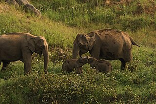
Kali Tiger Reserve is a protected area and tiger reserve. It is located in Uttara Kannada district, in Karnataka, India. The park is a habitat of Bengal tigers, black panthers and Indian elephants, amongst other distinctive fauna. The Kali River flows through the tiger reserve and is the lifeline of the ecosystem and hence the name. The tiger reserve is spread over an area of 1300 square kilometres.

Vansda National Park, also known as Bansda National Park, is a protected area which represents the thick woodlands of the Dangs and southern Gujarat, and is situated in the Vansda tehsil, Navsari District of Gujarat state, India. Riding on the banks of Ambika River and measuring roughly 24 km2 in area, the park lies about 65 km east of the town of Chikhali on the National Highway 48, and about 80 km northeast of the city of Valsad. Vansda, the town from which the name of the park is derived, is an important trading place for the surrounding area where the majority of the population is represented by adivasis. Vansda-Waghai state highway runs through the park, so does the narrow gauge rail link connecting Waghai to Billimora.

The Narmada Valley dry deciduous forests are a tropical dry forest ecoregion of central India. The ecoregion lies mostly in Madhya Pradesh state, but extends into portions of Chhattisgarh, Maharashtra, Karnataka and Uttar Pradesh states.

Koyna Wildlife Sanctuary is a wildlife sanctuary and natural World Heritage Site, which is located in Satara district of the Indian state of Maharashtra. Further, this wildlife sanctuary is designated as an Important Bird area. The sanctuary is nested in the Western Ghats, covering an area of around 423.55 km2 (163.53 sq mi), and elevations ranging from 600 to 1,100 m. It was notified in 1985 as a wildlife sanctuary situated in Maharashtra. It forms the northern portion of the Sahyadri Tiger Reserve, with Chandoli National Park forming the southern part of the reserve.

Karad is a town in Satara district of Indian state of Maharashtra. It is located 302 km (180.19 miles) from Mumbai, 74 km from Sangli and 162 km from Pune. It lies at the confluence of Koyna River and the Krishna River known as the "Pritisangam". The two rivers originate at Mahabaleshwar, which is around 100 km from Karad. Karad is well known for sugar production and is known as the sugar bowl of Maharashtra owing to the presence of many sugar factories in and around Karad. It is considered an important educational hub in Western Maharashtra due to the presence of many prestigious educational institutes. Karad is resting place of the first chief minister of Maharashtra Yashwantrao Chavan situated at the confluence of the Krishna and Koyana rivers. It is ranked as the cleanest town in Swachh Survekshan 2020 in the category of population with less than 1 lakh.
Bhimashankar Wildlife Sanctuary was created in the Ambegaon and Khed talukas of Pune District, in the Western Indian state of Maharashtra in order mainly to protect the habitat of the Indian Giant Squirrel.

The word Maharashtra, the land of the mainly Marathi-speaking people, appears to be derived from Maharashtri, an old form of Prakrit. Some believe that the word indicates that it was the land of the Mahars and the Rattas, while others consider it to be a corruption of the term 'Maha Kantara', a synonym for 'Dandakaranya'. Maharashtra is the third largest state in India after Rajasthan and Madhya Pradesh. It covers an area of 307,713 km2 and is bordered by the states of Madhya Pradesh to the north, Chhattisgarh to the east, Telangana to the southeast, Karnataka to the south and Goa to the southwest. The state of Gujarat lies to the northwest, with the Union territory of Dadra and Nagar Haveli sandwiched between the borders. Maharashtra has coastline of 720 km.The Arabian Sea makes up Maharashtra's west coast. Maharashtra consists of two major relief divisions. The plateau is a part of the Deccan tableland and the Konkan coastal strip abutting on the Arabian Sea.
Radhanagari Wildlife Sanctuary is a wildlife sanctuary and natural World Heritage Site of category ix and x since 2012, located in Kolhapur district, Maharashtra State, India. It lies at the southern end of the Sahyadri hills in the Western Ghats. It is notable as the first declared wildlife sanctuary in Maharashtra, notified in 1958, as "Dajipur Wildlife Sanctuary" and is popularly known as the "Bison Sanctuary". Indian bison or gaur with a population around 1091 in 2014, is the flagship species of the area. It was notified as Radhanagari wildlife sanctuary vide notification No. WLP/1085/CR/588/ V/F-5, Dt.16.9.1985. The area around the Sanctuary was declared as Eco sensitive zone by Govt. of India on 15 October 2020

The state of Karnataka in South India has a rich diversity of flora and fauna. It has a recorded forest area of 38,720 km2 which constitutes 55% of the geographical area of the state. These forests support 25% of the elephant population and 20% of the tiger population of India. Many regions of Karnataka are still unexplored and new species of flora and fauna are still found.

The Tadoba Andhari Tiger Reserve is a wildlife sanctuary in Chandrapur district of Maharashtra state in India. It is Maharashtra's oldest and largest national park. Created in 1955, the reserve includes the Tadoba National Park and the Andhari Wildlife Sanctuary. The reserve consists of 577.96 square kilometres (223.15 sq mi) of reserved forest and 32.51 square kilometres (12.55 sq mi) of protected forest.
Sahyadri Tiger Reserve is a reserve in the state of Maharashtra, created by the Indian government in 2008. Located in the Sahyadri Ranges of the Western Ghats of Maharashtra, it is part of the ecoregions of North Western Ghats moist deciduous forests and North Western Ghats montane rain forests. These ranges form a common boundary between Maharashtra, Karnataka and Goa, and constitute rich evergreen, semi-evergreen and moist deciduous forests. The area is spread over the four districts of Satara, Sangli, Kolhapur and Ratnagiri.
Prachitgad is a fort in the Sahyadri mountain range in Sangli district of Maharashtra state, India. It covers an area of 5 acres (20,000 m2).
Karian Shola National Park is a protected area in the Western Ghats, India, nominated as a national park in 1989. The Western Ghats are a chain of mountains running down the west of India parallel with the coast some 30 to 50 km inland. They are not true mountains, but the edge of a fault that resulted about 150 million years ago as the subcontinent of India split from Gondwanaland. They are older than the Himalayan mountain range and are clothed in ancient forests. They influence the weather in India as they intercept the incoming monsoon storm systems. The greatest rainfall occurs between June and September during the southwest monsoon, with lesser amounts falling in the northeast monsoon between October and November. The Western Ghats are a UNESCO World Heritage Site and are considered to be one of the eight most important "hotspots" of biological diversity in the world.

The Mhadei Wildlife Sanctuary is a 208.5-km2 (80.5-mi2) protected area in the Indian state of Goa in the Western Ghats of South India. It is located in the North Goa District, Sattari taluka near the town of Valpoi. The sanctuary is an area of high biodiversity, and is being considered to become a Project Tiger tiger reserve because of the presence of Bengal tigers.

Purna Wildlife Sanctuary is a wildlife sanctuary in the Western Ghats mountain range, in the States of Gujarat and Maharashtra, India. In the South Gujarat, it is located between Vyara, Tapi District and Ahwa, Dang District, and in Maharashtra, it is located in Nandurbar District. Apart from the Dangs' District, it is a part of the Northern Division of the Dangs' Forest.