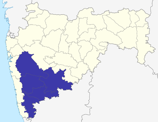
Pune Division is one of the six administrative divisions of the Indian State of Maharashtra. Pune Division is bound by Konkan Division to the west, Nashik Division to the north, Aurangabad Division to the east, and the state of Karnataka to the south.

Sangli district is a district of Maharashtra state in India. Sangli city is the district headquarters. It is bordered by Satara district, Solapur district to the North, Karnataka state to South-East, by Kolhapur district to South-West and by narrow portion in East side to Ratnagiri district. It is present on the southern tip of Maharashtra.
Madhavnagar is a small city in sangli and now Suburb of Sangli Urban; Sangli district in the Indian state of Maharashtra.
Tasgaonpronunciation (help·info)Tasgaon is a city in Maharashtra and a municipal council in Sangli district in the Indian state of Maharashtra. Tasgaon city is developing city in Maharashtra. Tasgaon was given as Jahagir to Parshuram Bhau Tasgaonkar by Narayanrao Ballal Peshwa in 1774. Tasgaon Sansthan was lapsed by British during ruling of Shrimant Ganpatrao Tasgaonkar.
Khatav is a town and taluka located in the Man-Khatav subdivision of the Satara district, India.
Jat is a town and taluka headquarters in Miraj subdivision of Sangli district in southern Maharashtra.
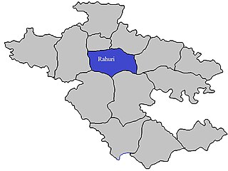
Rahuri taluka, is a taluka in the Shrirampur subdivision of the Ahmednagar district in Maharashtra, India.
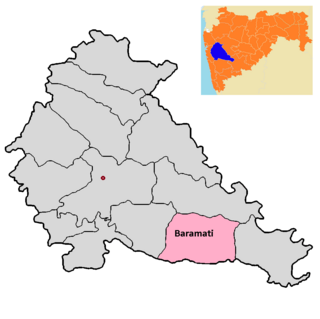
Baramati taluka is a taluka in Baramati subdivision of Pune district of state of Maharashtra in India.
Bhood is a village in Khanapur tehsil of Sangli district in Maharashtra, India. It is located near the city Vita.
Sangli Assembly constituency is one of the 288 Vidhan Sabha constituencies of Maharashtra state in western India.
Kotij is a suburb of Sangli District in the Indian state of Maharashtra.
Hasur is a village in Maharashtra, India. It is located in the Krishna river basin, in the Desh region. The village is a part of the Shirol taluka of Kolhapur district, Pune Division.
Wangi is a village in Kadegaon taluka, Sangli district, Maharashtra, India. The population was 9,895 at the 2011 Indian census.
Vadgaon is a census town in Nashik district in the Indian state of Maharashtra.
Upalavi is a village in the Tehsil tasgaon of Sangli district, Maharashtra, India, about 18 kilometres north of Sangli. It is situated along the Sangli-Tasgaon state highway.
Erandoli is a village in Miraj Taluka in Sangli District of Maharashtra State, India. It belongs to Desh or Paschim Maharashtra region. It is in Pune Division. It is located 9 km (5.6 mi) east of the district headquarters Sangli and 361 km (224 mi) from the state capital at Mumbai.

Vaduj is a major town in Satara district of Maharashtra, India. It is the headquarters of Khatav Taluka. It is located on the banks of the Yerala River, and is around 58 kilometres (36 mi) away from the district capital Satara, and 165 kilometres (103 mi) away from Pune. It is the biggest town in Khatav Taluka, with a population of around 17,636 people. Recently, its status was changed to Nagar Panchayat.
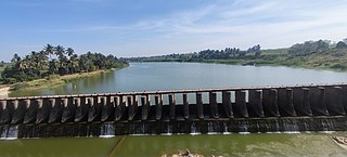
The Yerla River, alternatively Yerala River, is a tributary of Krishna River. It originates from the Mhaskoba hills in the extreme north of Khatav taluka of Satara district. It flows along a valley flanked by the Vardhangad range to its right and the Mahimangad range to its left and its total length is about 125 km. In Satara district, it passes through Mol, Lalgun, Pusegaon, Khatav, Vaduj and Nimsod. Later in Sangli district it joins Krishna River near Brahmanal. The Yerala is nonperennial river. This river is a major source of irrigation in the eastern part of Satara district and Sangli district in Maharashtra and helpful for seasonal agriculture production. The drainage network influences the economic and social development of people.
Kakadwadi is a village in Miraj Taluka in Sangli District of Maharashtra State, India. It belongs to Desh or Paschim Maharashtra region, belongs to Pune Division. It is located 14 km towards North from District headquarters Sangli, 13 km from Miraj, 348 km from State capital. Kakadwadi Local Language is Marathi.

The Nandani River is a right tributary of Yerla River in India. It originates at Jaigaon and flows from Aundh in Satara district and confluence to Yerala river near Shivani village of Kadegaon taluka, in Sangli district of Maharashtra state.
