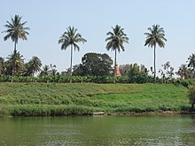
The Krishna River is a river in the Deccan plateau and is the third-longest river in India, after the Ganges and Godavari. It is also the fourth-largest in terms of water inflows and river basin area in India, after the Ganges, Indus and Godavari. The river, also called Krishnaveni, it is 1,400 kilometres (870 mi) long and its length in Maharashtra is 282 kilometres. It is a major source of irrigation in the Indian states of Maharashtra, Karnataka, Telangana and Andhra Pradesh.
Sangli is a Metro city and the headquarters of Sangli District in Maharashtra, in western India. It is known as the Turmeric City of Maharashtra due to its production and trade of spice. Sangli is situated on the banks of river Krishna and houses many sugar factories. Sangli is a significant city in Western India, 376 km from Mumbai, 233 km from Pune, 47 km from Kolhapur, and 638 km from Bangalore. Sangli is known for its turmeric trade, grapes and the most significant number of sugar factories in India. The only district has more than 30 sugar factories. Sangli Miraj Kupwad, along with its Urban Agglomeration, together known as Sangli Miraj Kupwad Metropolitan Region (SMKMR).
Yashwantrao Chavan Sagareshwar Wildlife Sanctuary is a protected area in the Indian state of Maharashtra. It is located at the meeting of three Tehsils of Sangli district: Kadegaon, Walva and Palus. The wildlife sanctuary is man-made; it is an artificially cultivated forest without a perennial supply of water, and most of the wildlife species were artificially introduced. It has an area of 10.87 km².
Kirloskarvadi is India's second oldest industrial township that developed around the Kirloskar Brothers Ltd factory in the Palus Sangli district, in Maharashtra state, India. It is the second oldest industrial township in India. On 10 March 2010, Kirloskarvadi celebrated 100 years of its establishment. Kirloskarvadi is a rapidly growing satellite suburb of Palus city. The famous holy place of God Datta Maharaj Audumbar is just 10 km away. While Sagareshwar picnic spot is around 8–10. The town has centric connectivity between Satara-Sangli-Kolhapur
Murtijapur is a Municipal council and one of the taluka of district of Akola of the Amravati division of the Vidarbha region of Maharashtra.

Sangli district is a district of Maharashtra state in India. Sangli city is the district headquarters. It is bordered by Satara district, Solapur district to the North, Karnataka state to the South-East, by Kolhapur district to South-West and by narrow portion on the East side to Ratnagiri district. It is present on the southern tip of Maharashtra.
Dhrangadhra is a town, taluka headquarters and a municipality in Surendranagar district in the state of Gujarat, India. During the period of the British Raj, the city was the capital of Dhrangadhra State, one of the eight first-class princely states of the Kathiawar Agency in the Bombay Presidency.

Chiplun is a city in Ratnagiri district in the state of Maharashtra, India. It is the one of the financial and commercial Hubs of Ratnagiri district, and the headquarters of Chiplun taluka. It is about 250 km south of Mumbai and 90 km North of Ratnagiri in the Konkan region of Maharashtra, on the Mumbai–Goa highway (NH-66). It has a long history and a strong cultural background. Recent decades have seen much industrial development in it and its and surrounding areas.

Karad is a city in Satara district of Indian state of Maharashtra and it is 302 km (180.19 miles) from Mumbai, 74 km From Sangli and 162 km from Pune. It lies at the confluence of Koyna River and the Krishna River known as the "Priti sangam". The two rivers originate at Mahabaleshwar, which is around 100 km from Karad. They diverge at their origin and travel about the same distance to meet again in Karad. The rivers meet exactly head-on, thus forming the letter "T" which is the only head-on confluence in the world. Hence Krishna and Koyna river's confluence is called Preeti Sangam, meaning Confluence of Love. Karad is well known for sugar production and is known as the sugar bowl of Maharashtra owing to the presence of many sugar factories in and around Karad. It is considered an important educational hub in Western Maharashtra due to the presence of many prestigious educational institutes. This place is also known as the resting place (Samadhi) of the first chief minister of Maharashtra Shri. Yashwantrao Chavan situated at the confluence of the Krishna and Koyana rivers.
Tasgaonpronunciation (help·info)Tasgaon is a city in Maharashtra and Taluka in Sangli district in the Indian state of Maharashtra. Tasgaon city is developing city in Maharashtra. Tasgaon was given as Jahagir to Parshuram Bhau Tasgaonkar by Narayanrao Ballal Peshwa in 1774. Tasgaon Sansthan was lapsed by British during ruling of Shrimant Ganpatrao Tasgaonkar.
Vita, also known as Vite, is a city and a municipal council in Sangli district in the Indian state of Maharashtra. Vita is also taluka headquarters of Khanapur taluka.
Vaibhavwadi taluka is a taluka in Kankavli subdivision of Sindhudurg district in the Indian state of Maharashtra.
Shirol is a historic place. In a great war between Chhatrapati Shivaji Maharaj and the Mughal Empire, the Mughals were defeated and the heads of Mughal soldiers were hanged at the main gate of city. So the name Shirol: Shir (heads) + ol (row).
Palus is a city and municipal council in sangli district. Palus is developed city in Sangli district. City have best industrial zone, steel firms, foundries and Precision Machine shop.

Amboli is a small village in the southern Konkan Division, Sindhudurg district, Maharashtra state, India. Amboli Ghat lies at an altitude of approximately 700 metres above sea level and is the last hill resort before ending in the coastal plains of Goa state.

Ganagapura is a Village in Karnataka, India. It is located in the Afzalpur taluk of Kalaburagi district in Karnataka.The Village is noted for its Temple to Lord Dattatreya, who is said to have attained realization on the banks of the confluence (Sangama) of rivers Bhima-Amarja.
Nrusinhawadi commonly known as Narsobawadi or Narsobachi Wadi is a small town in Shirol Tahasil in Kolhapur district, Maharashtra. Narsobawadi gets its name from the presence of 'Shri Nrusinha Saraswati', the Purna Avatar of Lord Dattatreya.
Arjunwad is a village in Belagavi district in the Northern state of Karnataka, India.
Bhilawadi is a town which located in palus taluka. it is near about only 16 km from Palus city. Bhilawadi, located on the bank of Krishna River. This town is one of the prominent producers of Grapes and Sugar Cane in Sangli district. Bhilawadi town has won the Nirmal Gram Purskar in Sant Gadage Baba Gram Swachhata Abhiyan.
Kirloskarvadi railway station is one of the important railway station in Palus, Sangli district, Maharashtra and on Central Railway line. Station code is KOV. It serves for Kirloskarvadi town and connectivity station for Palus–Tasgaon–Islmapur–Vita-Karad Talukas. The station consists of two platforms with completed electrification. The first electric train is expected to run on this line from Kolhapur to Mumbai by December 2021,trial run is completed on this line. The station is opposite the largest industrial township of Kirloskar Group. Famous Datta Maharaj Holy place Audhumbar is just 11 km away. Sagareshwar Wild Life Sanctuary is just 5 km from Kirloskarvadi station. There are trains to major cities like Pune, Mumbai, Delhi, Ahmedabad, Vadodara, Bhopal, Belgaum, Hubli, Jodhpur, Lonavala, Guntakal, Rajkot, Gandhidham, Goa and Bangalore.