Kaza, Himachal Pradesh

Last updated

Kaza, Himachal Pradesh
Kaza
Karze or Karzey
town
Kaza - Losar Entry point.jpg
Kaza Losar Entry Gate
India Himachal Pradesh location map.svg
Red pog.svg
Kaza, Himachal Pradesh
Location in Himachal Pradesh, India
Coordinates: 32°13′32″N78°04′17″E / 32.22556°N 78.07139°E / 32.22556; 78.07139
CountryFlag of India.svg  India
State Himachal Pradesh
District Lahaul and Spiti
Elevation
3,800 m (12,500 ft)
Population
  Total3,231
Languages
  Official Urdu
Time zone UTC+5:00 (PST)
PIN
172114
Telephone code01906 - STD code
Vehicle registration H.P.- 41
Sex ratio 974 /
Downtown Kaza Downtown Kaza. Spiti.jpg
Downtown Kaza
Family at home with visitors, Kaza, 2004 Kaza 28-6-04 009.jpg
Family at home with visitors, Kaza, 2004

Kaza, also spelled Kaze, Karze, Karzey, is a town and the subdivisional headquarters of the remote Spiti Valley in the western Himalayas in the Lahaul and Spiti district of the northern Indian state of Himachal Pradesh. Spiti is a high altitude or cold desert having close similarities to the neighbouring Tibet and Ladakh regions in terms of terrain, climate and the Buddhist culture. Kaza, situated along the Spiti River at an elevation of 3,650 m (11,980 ft) above mean sea level, is the largest township and commercial center of the Spiti valley.

Contents

Description

The town is divided into the old, as Kaza Khas and new as Kaza Soma sections. The new town contains the administrative buildings. The Tangyud (Tang-rGyud) Gompa dates to the early 14th century and is built like a fortified castle with massive slanted mud walls and battlements with vertical red ochre and white vertical stripes. It is on the edge of a deep canyon and overlooking the town of Kaza, 4 km from the town. [1] [2] Approaching it from the south one sees Kyu-ling (Skyid-gling), the stately palace of the Nono (king) on the other side of the river. [3]

Access

Kaza is overlooked by high mountain ridges on the NE and SW sides. The Spiti River runs from NW to SE past Kaza. Kaza has two access routes: one from Kinnaur valley and the other from the Lahaul valley. The route via NH 505 through Kinnaur is open throughout the year, except for occasional short periods resulting from landslides or heavy snowfall. This road, starting from Shimla, follows the Sutlej river unto a little beyond Poo, thereafter turning northwards to follow the Spiti river all the way to Kaza. The other road starts from Manali and after crossing the 13,090 ft (3,990 m) high Rohtang Pass to reach Gramphoo where it joins the road from Keylong and proceeds south along Chandra River till Batal then climbs up to cross the 14,928 ft (4,550 m) high Kunzum pass, enters the Spiti valley to reach Kaza. It remains closed during winter months, normally from October end to June due to heavy snowfall on both the passes. [4] Kaza is one of the coldest towns in India. The temperature varies greatly in different seasons as well as within a day. January is the coldest month of the year with an average temperature of -25 °C, while July is the hottest month with an average temperature of 10 °C.[ citation needed ]

Festivals and tourism

Kaza is known for its colorful festivals and the ruins of the ancient Sakya Tangyud Monastery, located near village Komik,14 km from Kaza. It is also popular with tourists and adventure seekers during the period of June, July and August and September because of its central location and connections to the rest of the valley (Connects to Leh-Manali Highway via Kunzum Pass). This central location also makes Kaza an ideal base camp for trekking, mountaineering, and tours directed to other parts of the valley.

The prominent festivals celebrated in Kaza are Ladarcha (mid-August), Spiti Losar (around November), and Dachang (around February). Kaza's Ladarcha fair is the most renowned fair of Kaza; it indicates the termination of summer season in the region.

Previously, Ladarcha fair used to be celebrated  in Kibbar maidan in Spit in the month of July where traders from  Ladakh, Rampur Busher and Spiti meet in this fair to barter their produce. Due to closure of Tibetan traders, this fair is  now being celebrated at Kaza, the headquarters of Spiti Sub Division in the 3rd week of August. A large number of visitors  and traders from Kullu/ Lahaul/ Kinnaur meet there. It has now  become a conference of cultures of Spiti, Ladakh & Kinnaur as also of the Indian plains.

The highest post office in the world at Hikkim village (PIN 172114) at an elevation of 4,400 m (14,400 ft) is situated 46 km (29 mi) from Kaza. It sends postal letters to and receives postal articles from Kaza post office. [5] [6]

Hikkim- The World's Highest Post Office Hikkim- The World's Highest Post Office.jpg
Hikkim- The World’s Highest Post Office

Monasteries

Sakya Monastery, Kaza Sakya Kaza Monastery.jpg
Sakya Monastery, Kaza

Sakya Tangyud monastery; built in the year 2009, Sakya Tangyud monastery is situated in Kaza town of Spiti Valley. Key (Ki) Monastery was built by Dromton, a student of the renowned instructor, Atisha, in the eleventh century and is located at a height of 4,166 m (13,668 ft) about 12 km (7.5 mi) north of Kaza town.

Facilities

Community Health Centre, Kaza, 2004 Spiti 1-7-04 (1) 062.jpg
Community Health Centre, Kaza, 2004
Petrol bunk at Kaza Indianoil Corporation World's Highest Altitude Retail Outlet sign. Ladakh. 2010.jpg
Petrol bunk at Kaza

In 2022, the Himachal Pradesh government constructed an indoor gym at a cost of Rs. 10 lakhs (1 million). With development of the region over the past few years, local residents get less physical activity. They report that lifestyle diseases such as heart diseases, blood pressure and diabetes have made an appearance. The gym is expected to provide an alternative over addition to gadgets and drugs for the youth. Tourists may also use the gym to adapt to high-altitude. The gym is said to be the highest in the world, though this is yet to be verified. [7]

The only petrol bunk in Spiti is located in Kaza. The town has a Community Health Centre and a Police Station. Mobile internet services are provided by BSNL, Airtel 4G and Jio 4G. [8]

Rangrik airbase

Thr Indian Military is constructing an airbase at Rangrik (7 km northwest of Kaza & 100 km west of Kaurik on LAC) in Spiti valley which will also cater for the civilian flights. It was announced in the January 2023, and it will be completed by end of 2024. [9]

Highways

Hanle-Kaza-Tabo Road is being construction by the BRO under Indo-China Border Roads (ICBR) scheme.

NH505 connects Kaza to Manali in southwest, and Kaurik, Sumdo, Pooh & Tabo in east. Kaza-Pooh-Tabo-Shimla route is open whole year, but the Manali-Kaza route is closed for 7 winter months every year during which Kunzum Pass (15,000 ft) is closed. NHAI is planning to construct a tunnel under the Kunzum Pass to provide all-weather connectivity between Manali and Spiti valley. [10]

See also

Related Research Articles

<span class="mw-page-title-main">Lahaul and Spiti district</span> A district in Himachal Pradesh, India

The Lahaul and Spiti district in the Indian state of Himachal Pradesh consists of the two formerly separate districts of Lahaul and Spiti. The present administrative center is Kyelang in Lahaul. Before the two districts were merged, Kardang was the capital of Lahaul, and Dhankar the capital of Spiti. The district was formed in 1960 and is the fourth least populous district in India. It is the least densely populated district of India, according to the Census of India 2011.

<span class="mw-page-title-main">Kyelang</span> Town in Himachal Pradesh, India

Kyelang is a town and the administrative centre of the Lahaul and Spiti district in the Indian state of Himachal Pradesh, 71 kilometres (44 mi) north of Manali via Atal Tunnel and 120 km (75 mi) from the Indo-Tibetan border. It is located along the Manali-Leh Highway, about 7 km northeast of intersection of the Chandra, Bhaga, and Chenab valleys, on the banks of Bhaga River.

<span class="mw-page-title-main">Tabo, Himachal Pradesh</span> Town and village in Himachal Pradesh, India

Tabo is a small town in the Lahaul and Spiti district on the banks of the Spiti River in Himachal Pradesh, India. The town lies on the road between Rekong Peo and Kaza, the sub-divisional headquarters of Spiti. The town surrounds a Buddhist monastery which, according to legend, is said to be over a thousand years old. The Dalai Lama has expressed his desire to retire to Tabo, since he maintains that the Tabo Monastery is one of the holiest. In 1996, the Dalai Lama conducted the Kalachakra initiation ceremony in Tabo, which coincided with the millennium anniversary celebrations of the Tabo monastery. The ceremony was attended by thousands of Buddhists from across the world. Tabo Monastery's spiritual head is Tsenshap Serkong Rinpoche.

<span class="mw-page-title-main">Geography of Himachal Pradesh</span>

The state of Himachal Pradesh is spread over an area 55,673 km2 (21,495 sq mi) and is bordered by Jammu and Kashmir and Ladakh on the north, Punjab on the southwest, Haryana on the south, Uttarakhand on the southeast, a small border with Uttar Pradesh in the south, and Tibet on the east. Entire Himachal Pradesh lies in the mountainous Himalaya region, rich in natural resources

<span class="mw-page-title-main">Dhankar Gompa</span>

Dhankar Gompa is a village and also a Gompa, a Buddhist temple in the district of Lahaul and Spiti in India. It is situated at an elevation of 3,894 metres in the Spiti Valley above Dhankar Village, between the towns of Kaza and Tabo. The complex is built on a 1000-foot (300-metre) high spur overlooking the confluence of the Spiti and Pin Rivers - one of the world's most spectacular settings for a gompa. Dhang or dang means cliff, and kar or khar means fort. Hence Dhangkar means fort on a cliff.

<span class="mw-page-title-main">Spiti</span> River valley in Himachal Pradesh, India

Spiti is a high-altitude region of the Himalayas, located in the north-eastern part of the northern Indian state of Himachal Pradesh. The name "Spiti" means "The middle land", i.e. the land between Tibet and India. Spiti incorporates mainly the valley of the Spiti River, and the valleys of several rivers that feed into the Spiti River. Some of the prominent side-valleys in Spiti are the Pin valley and the Lingti valley. Spiti is bordered on the east by Tibet, on the north by Ladakh, on the west and southwest by Lahaul, on the south by Kullu, and on the southeast by Kinnaur. Spiti has a cold desert environment. The valley and its surrounding regions are among the least populated regions of India. The Bhoti-speaking local population follows Tibetan Buddhism.

<span class="mw-page-title-main">Leh–Manali Highway</span> High elevation mountain highway in India

The Leh–Manali Highway is a 428 km (266 mi) long highway in northernmost India connecting Leh, the capital of the Union Territory of Ladakh, to Manali in the state of Himachal Pradesh. It crosses four passes Rohtang la, Baralacha la, lungalacha la, tanglang la. It connects the Kullu Valley of the upper Beas river to the Chandra and Bhaga river valleys of Lahaul via the Atal tunnel in Himachal Pradesh, then crosses over a series of high Himalayan passes into the Indus river valley in Ladakh. It is usually open for about six months a year from the first week of May when the snow is cleared from the highway to October when snowfall again blocks the high passes on the highway. Before the construction of the Atal tunnel, the highway used to remain closed beyond the Rohtang Pass during winter. With the completion of the proposed Shingo La Tunnel on an alternate route through Zanskar valley, targeted to be completed by 2025, the whole Leh-Manali route will become an all-weather road.

Himachal Pradesh, although railways and airways serve very limited transport needs, the road network of the state serves the transport needs of the people. Although, the geography of Himachal presents considerable challenge to the development of transport infrastructure, it has the highest road density among all the Hill States of India. Himachal also has 3 airports, 2 narrow gauge rail tracks and couple of other under-construction broad gauge railway tracks, but roads remain the main mode of transport.

<span class="mw-page-title-main">Suraj Tal</span> Lake in Himachal Pradesh, India

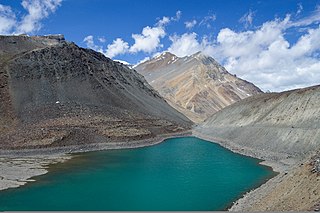
Suraj Tal, also called Tso Kamtsi or Surya Tal, is an 800 m (2,600 ft) long lake that lies just below the 4,890 m (16,040 ft) high Bara-lacha-la pass in Lahaul and Spiti district of the Indian state of Himachal Pradesh. It is the third-highest lake in India and the 21st-highest in the world. Suraj Tal Lake is just below the source of the Bhaga River that joins the Chandra River downstream at Tandi to form the Chandrabhaga River in Himachal Pradesh. The Chandrabhaga River is known as the Chenab as it enters the Jammu region of Jammu and Kashmir. The other major tributary of the Chandrabhaga, the Chandra, originates and flows south-east of the Bara-lacha La.

<span class="mw-page-title-main">Key Monastery</span> Tibetan Buddhist monastery in Spiti, Himachal Pradesh, India

Kye Gompa is a Tibetan Buddhist monastery of the Gelugpa sect located on top of a hill at an altitude of 4,166 metres (13,668 ft) above sea level, close to the Spiti River, in the Spiti Valley of Himachal Pradesh, Lahaul and Spiti district, India.

<span class="mw-page-title-main">Kunzum Pass</span> Mountain pass in the Indian Himalayas

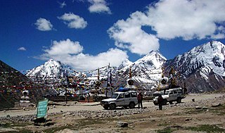
Kunzum Pass, is a high mountain pass in the eastern Kunzum Range of the Himalayas. It connects Lahaul valley and Spiti valley. It is on the route from Gramphoo in Lahaul to Kaza the subdivisional headquarters of Spiti. Kunzum Pass on NH505 is 122 km (76 mi) from Manali, and 79 km (49 mi) from Kaza.

<span class="mw-page-title-main">Tabo Monastery</span> Tibetan Buddhist monastery in Tabo, Himachal Pradesh, India

Tabo Monastery is located in the Tabo village of Spiti Valley, Himachal Pradesh, northern India. It was founded in 996 CE in the Tibetan year of the Fire Ape by the Tibetan Buddhist lotsawa (translator) Rinchen Zangpo, on behalf of the king of western Himalayan Kingdom of Guge, Yeshe-Ö. Tabo is noted for being the oldest continuously operating Buddhist enclave in both India and the Himalayas. A large number of frescoes displayed on its walls depict tales from the Buddhist pantheon. There are many priceless collections of thankas, manuscripts, well-preserved statues, frescos and extensive murals which cover almost every wall. The monastery is in need of refurbishing as the wooden structures are aging and the thanka scroll paintings are fading. After the earthquake of 1975, the monastery was rebuilt, and in 1983 a new Du-kang or Assembly Hall was constructed. It is here that the 14th Dalai Lama held the Kalachakra ceremonies in 1983 and 1996. The monastery is protected by the Archaeological Survey of India (ASI) as a national historic treasure of India.

<span class="mw-page-title-main">Tangyud Monastery</span> Tibetan Buddhist monastery near Hikkim, Himachal Pradesh, India

The Tangyud Monastery or Sa-skya-gong-mig Gompa at the village of Komic, two km southeast of Hikkim in the Spiti Valley of Himachal Pradesh, India, is built like a fortified castle on the edge of a deep canyon, with massive slanted mud walls and battlements with vertical red ochre and white vertical stripes which make them look much taller than they really are. It is one of the highest altitude gompas (monasteries) in India, at an altitude of 4,520 metres (14,830 ft), on the edge of a deep canyon and overlooking the town of Kaza, Spiti 4 km to the west. It is located on the periphery of the Kibber Wildlife Sanctuary.

<span class="mw-page-title-main">Kibber</span> High-altitude village in Himachal Pradesh, India

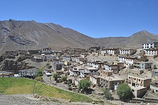
Kibber, also Kibber Khas and Khyipur, is a village high in the Spiti Valley in the Himalayas at 4,270 m (14,010 ft) in Himachal Pradesh in northern India. It contains a monastery and is a base for visiting the Kibber Wildlife Sanctuary. It is located 19 km (12 mi) from Kaza and a bus service connects them in the summer months. Agriculture forms the backbone of the local economy and lush green fields are abundant. It is the base for visitors to the Kibber Wildlife Sanctuary, home to about 30 snow leopards. Treks to nearby peaks and to a high pass in the Zanskar range between Spiti and Ladakh start from Kibber.

<span class="mw-page-title-main">Buddhism in Himachal Pradesh</span>

Buddhism in the Himachal Pradesh state of India of has been a long-recorded practice. The spread of Buddhism in the region has occurred intermediately throughout its history. Starting in the 3rd century BCE, Buddhism was propagated by the Maurya Empire under the reign of Ashoka. The region would remain an important center for Buddhism under the Kushan Empire and its vassals. Over the centuries the following of Buddhism has greatly fluctuated. Yet by experiencing revivals and migrations, Buddhism continued to be rooted in the region, particularly in the Lahaul, Spiti and Kinnaur valleys.

<span class="mw-page-title-main">National Highway 505 (India)</span> National Highway in Himachal Pradesh, India

National Highway 505, commonly called NH 505, is a national highway in India. It is a spur road of National Highway 5. NH-505 traverses the state of Himachal Pradesh in India. NH505 a high elevation road, covers Kinnaur and Lahaul and Spiti districts of Himachal Pradesh, mainly running along Spiti river in Spiti valley. The highway from Kaza to Gramphu remains closed for 6–9 months in a year due to heavy snowfall and closure of Kunzum La pass at an elevation of 4,550 m (14,930 ft).

Kaurik and is a village in the Lahul and Spiti district, in Himachal Pradesh, India. It is in the valley of the Parang or Pare Chu river before its confluence with the Spiti River. Kaurik is close to the border with Tibet, the opposite village on the Tibetan side being Tsurup Sumgyi. China claims the village as part of its Zanda County, Tibet.

<span class="mw-page-title-main">Nimmu–Padum–Darcha road</span> Road in India

Nimmu–Padum–Darcha road (NPDR) or Zanskar Highway is a road between the Indian union territory of Ladakh and the state of Himachal Pradesh, passing through the region of Zanskar. It connects Nimmu in the Indus Valley to Padum, the capital of Zanskar, and to Darcha village in Lahul and Spiti. It provides an alternative to the Leh–Manali Highway in linking Ladakh with the rest of India. It was built by the Border Roads Organisation (BRO) of the Indian Army. The construction of road was completed in March 2024. The already completed Atal tunnel, and the proposed unidirectional-twin-tube total-4-lane Shingo La Tunnel, which is expected to be completed by 2025 will provide all weather connectivity and reduce the distance from Manali to Kargil by 522 km.

<span class="mw-page-title-main">Mud (village)</span> Village in Himachal Pradesh, India

Mud is a small village in the cold desert region of Spiti in Himachal Pradesh, India. Located at an altitude of 3,810 m (12,500 ft) on the left bank of the Pin River, a right bank tributary of the Spiti River, the village is nestled at the base of the Parbati range that towers almost vertically 1,600 m (5,200 ft) above. Mud is near the boundary of the Pin Valley National Park and is a convenient base for treks in the park, and to the neighbouring districts of Kullu and Kinnaur. It is the last village on the Spiti side of the Pin Parbati trek to Kullu and the Pin Bhaba trek to Kinnaur.

<span class="mw-page-title-main">Mane villages, Spiti</span> Twin villages in Spiti valley, Himachal Pradesh, India

Mane Kogma and Mane Yogma are two small villages on opposite banks of a nullah in the cold desert region of Spiti in Himachal Pradesh, India. The villages, at an altitude of 3,650 m (11,980 ft), are located on a small plateau about 200 m (660 ft) above the right bank of the Spiti River. Due to the lush green fields visible only after climbing the barren slope, the villages are referred to as the "hidden treasure".

References

  1. Handa (1987), pp. 83-85.
  2. Kapadia (1999), p. 204.
  3. Francke (1914), p. 44.
  4. "Lahaul & Spiti - land of lamas OR little Tibet OR Country of the gods OR The Land of haunting and unforgettable beauty". Himachal Tourism. Archived from the original on 6 December 2011. Retrieved 13 February 2009.
  5. "The world's highest post office". Archived from the original on 29 August 2018. Retrieved 28 August 2018.
  6. "The world's highest post office!". Rediff News. India. 20 September 2007. Archived from the original on 22 July 2011. Retrieved 28 August 2018.
  7. Bisht, Gaurav (16 July 2022). "Himachal govt sets up highest gym at Kaza in Spiti valley". Hindustan Times . Archived from the original on 18 July 2022. Retrieved 18 July 2022.
  8. "Government of Himachal Pradesh, District Lahaul and Spiti: Facilities". Archived from the original on 7 October 2022. Retrieved 18 July 2022.
  9. To counter China, Nyoma airfield in Ladakh to be full-fledged base in 2 years Archived 25 January 2023 at the Wayback Machine , The Tribune, 5 Jan 2023.
  10. Rs 200 cr for Sumdoh-Gramphu road Archived 25 January 2023 at the Wayback Machine , The Tribune, 14 June 2020.

Bibliography