
The Lahaul and Spiti district in the Indian state of Himachal Pradesh consists of the two formerly separate districts of Lahaul and Spiti. The present administrative center is Kyelang in Lahaul. Before the two districts were merged, Kardang was the capital of Lahaul, and Dhankar the capital of Spiti. The district was formed in 1960 and is the fourth least populous district in India. It is the least densely populated district of India, according to the Census of India 2011.

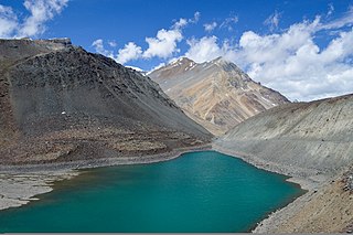
Chandra Taal, or Chandra Tal is a lake in the Spiti part of the Lahul and Spiti district of Himachal Pradesh, India. Chandra Taal is near the source of the Chandra River. Despite the rugged and inhospitable surroundings, it is in a protected niche with some flowers and wildlife in summer. It is a favourite spot for tourists and high-altitude trekkers. It is usually associated with Spiti, although geographically it is separated from Spiti. Kunzum La separates Lahaul and Spiti valleys.

Spiti is a high-altitude region of the Himalayas, located in the north-eastern part of the northern Indian state of Himachal Pradesh. The name "Spiti" means "The middle land", i.e. the land between Tibet and India. Spiti incorporates mainly the valley of the Spiti River, and the valleys of several rivers that feed into the Spiti River. Some of the prominent side-valleys in Spiti are the Pin valley and the Lingti valley. Spiti is bordered on the east by Tibet, on the north by Ladakh, on the west and southwest by Lahaul, on the south by Kullu, and on the southeast by Kinnaur. Spiti has a cold desert environment. The valley and its surrounding regions are among the least populated regions of India. The Bhoti-speaking local population follows Tibetan Buddhism.
Suraj Tal, also called Tso Kamtsi or Surya Tal, is an 800 m (2,600 ft) long lake that lies just below the 4,890 m (16,040 ft) high Bara-lacha-la pass in Lahaul and Spiti district of the Indian state of Himachal Pradesh. It is the third-highest lake in India and the 21st-highest in the world. Suraj Tal Lake is just below the source of the Bhaga River that joins the Chandra River downstream at Tandi to form the Chandrabhaga River in Himachal Pradesh. The Chandrabhaga River is known as the Chenab as it enters the Jammu region of Jammu and Kashmir. The other major tributary of the Chandrabhaga, the Chandra, originates and flows south-east of the Bara-lacha La.
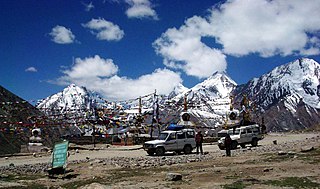
Kunzum Pass, is a high mountain pass in the eastern Kunzum Range of the Himalayas. It connects Lahaul valley and Spiti valley. It is on the route from Gramphoo in Lahaul to Kaza the subdivisional headquarters of Spiti. Kunzum Pass on NH505 is 122 km (76 mi) from Manali, and 79 km (49 mi) from Kaza.

Kaza, also spelled Kaze, Karze, Karzey, is a town and the subdivisional headquarters of the remote Spiti Valley in the western Himalayas in the Lahaul and Spiti district of the northernIndian state of Himachal Pradesh. Spiti is a high altitude or cold desert having close similarities to the neighbouring Tibet and Ladakh regions in terms of terrain, climate and the Buddhist culture. Kaza, situated along the Spiti River at an elevation of 3,650 m (11,980 ft) above mean sea level, is the largest township and commercial center of the Spiti valley.

Jispa is a village in Lahaul, in the Indian state of Himachal Pradesh.
Kibber, also Kibber Khas and Khyipur, is a village high in the Spiti Valley in the Himalayas at 4,270 m (14,010 ft) in Himachal Pradesh in northern India. It contains a monastery and is a base for visiting the Kibber Wildlife Sanctuary. It is located 19 km (12 mi) from Kaza and a bus service connects them in the summer months. Agriculture forms the backbone of the local economy and lush green fields are abundant. It is the base for visitors to the Kibber Wildlife Sanctuary, home to about 30 snow leopards. Treks to nearby peaks and to a high pass in the Zanskar range between Spiti and Ladakh start from Kibber.

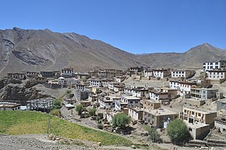
Dhankar Village is a large high village which used to be the capital of the Spiti Valley in Himachal Pradesh, India. It is at an altitude of 3,894 metres above sea level, between the towns of Tabo and Kaza, Himachal Pradesh. Above the village sits the local monastery - the Dhankar Gompa. Total number of houses are 68. The 40th head of the Gelug school of Tibetan Buddhism, Pelden Gyeltshen (1601-1674), came from Dhankar.

National Highway 3, or NH 3, is a national highway in India. It starts from Atari adjacent to India-Pakistan border and near Amritsar and terminates at Leh in Ladakh, via Manali in Himachal Pradesh.

Tinno is a village in Lahaul and Spiti district of Himachal Pradesh. It is around 14 km from Keylong, which is district headquarters. The village is along Manali-Leh Highway on left bank of Bhaga river, which originates from Suraj Taal lake. It has a total of 29 families residing in the village. The Tinno village has a population of 125, of which 59 are males while 66 are females as per Population Census 2011. In 2011, the literacy rate of Tinno village was 82.35%. In Tinno male literacy stands at 87.72% while female literacy rate was 77.42%. As per constitution of India and Panchyati Raaj Act, Tinno village is administrated by a Sarpanch who is elected representative of village.

National Highway 505, commonly called NH 505, is a national highway in India. It is a spur road of National Highway 5. NH-505 traverses the state of Himachal Pradesh in India. NH505 a high elevation road, covers Kinnaur and Lahaul and Spiti districts of Himachal Pradesh, mainly running along Spiti river in Spiti valley. The highway from Kaza to Gramphu remains closed for 6–9 months in a year due to heavy snowfall and closure of Kunzum La pass at an elevation of 4,550 m (14,930 ft).
Stod Bhoti (sTodpa), occasionally known as Lahul Bhoti or Lahuli, is a Tibetic language spoken in the Lahaul and Spiti district of Himachal Pradesh, India. It forms a closely knit group with other Lahuli–Spiti languages, and is fairly close to Standard Tibetan.

Gue is a village in the Lahul & Spiti district of the state of Himachal Pradesh in India. In this little village lays the perfectly well-preserved 593-year-old mummy of Sangha Tenzing. It was a Buddhist monk from Tibet. It was found in a sitting position, with his skin and hair intact. The village is about 40 km from the Tabo Monastery. The latitude 31.11 and longitude 77.16 are the geocoordinate of the Gue. Current Gue is controlled by India but claimed by Zanda County, Ngari Prefecture, Tibet, China.
Kaurik and is village in the Lahul and Spiti district, in Himachal Pradesh, India. It is in the valley of the Parang or Pare Chu river before its confluence with the Spiti River. Kaurik is close to the border with Tibet, the opposite village on the Tibetan side being Tsurup Sumgyi. China claims the village as part of its Zanda County, Tibet.

Mud is a small village in the cold desert region of Spiti in Himachal Pradesh, India. Located at an altitude of 3,810 m (12,500 ft) on the left bank of the Pin River, a right bank tributary of the Spiti River, the village nestles at the base of the Parbati range that towers almost vertically 1,600 m (5,200 ft) above. Mud is near the boundary of the Pin Valley National Park and is a convenient base for treks in the park, and to the neighbouring districts of Kullu and Kinnaur. It is the last village on the Spiti side of the Pin Parbati trek to Kullu and the Pin Bhaba trek to Kinnaur.

Mane Kogma and Mane Yogma are two small villages on opposite banks of a nullah in the cold desert region of Spiti in Himachal Pradesh, India. The villages, at an altitude of 3,650 m (11,980 ft), are located on a small plateau about 200 m (660 ft) above the right bank of the Spiti River. Due to the lush green fields visible only after climbing the barren slope, the villages are referred to as the "hidden treasure".
Tobdan is a historian and linguist from Himachal Pradesh, India. He is noted for his work on the cultural traditions, histories, and languages of the Lahaul and Spiti district, and some neighboring regions.

Leo is a small village in Kinnaur district, Himachal Pradesh, India. The village is situated on a mountain ridge on the right bank of the Spiti River. It is located 116 kilometres (72 mi) from Kaza on NH 505.


