Bari Brahmana is a town and a notified area committee in Samba district in the union territory of Jammu and Kashmir, India. The Industrial city has become the largest manufacturing centre of Jammu and Kashmir. Bari Brahmana has the largest number of industries in the state with a great share in industrial GDP of state. The name of the town is derived from two Dogri words 'Bari' meaning open ground and 'Brahmana' meaning Brahmins. Thus the name means 'the garden of Brahmins.'

Billawar is a town and a notified area committee in Kathua district of the Indian Union Territory of Jammu and Kashmir.
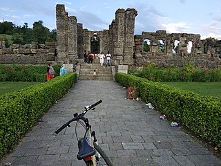
Charar-i-Sharief (Urdu pronunciation: [t͡ʃəraːreː ʃərɪf], known as Tsrar-i-Sharif in Kashmiri, is a town and a notified area committee in Budgam district in the Indian union territory of Jammu and Kashmir, India.
Gho Manhasan is a town and a Municipal committee in Jammu district in the state of Jammu and Kashmir, India.
Jammu Cantonment is a cantonment town in Jammu City in the Indian union territory of Jammu and Kashmir.
Jourian is a town and a notified area committee in Jammu district in the Indian administered union territory of Jammu and Kashmir.
Mattan is a town, tehsil and a notified area committee, near Anantnag city in Anantnag district of the Indian union territory of Jammu and Kashmir.

Pampore, known as Pampar or Panpar in Kashmiri, is a historical town situated on the eastern side of the Jhelum River on the Jammu-Srinagar National Highway in the Pulwama district of the Indian union territory of Jammu and Kashmir. It was known as Padmanpur in antiquity. It is famous worldwide for its saffron and known as the Saffron town of Kashmir. Pampore is one of the few places in the world where saffron, the world's most expensive spice, grows. The area is about 11 kilometres (6.8 mi) from Srinagar city centre Lal Chowk. Areas of Pampore typically have -bal as a suffix, such as the localities of Namlabal, Kadlabal, Drangbal, Frestabal, and Letrabal. Pampore has three lakes as well which have been entitled as wetlands. One of the lakes is known as Sarbal Lake. The Sarbal Lake is situated on the way from Tulbagh to Wuyan through saffron fields near Chatlam. On the basis of its location near Chatlam, it is also known as Chatlam Wetland.
Nagri Parole is a tehsil and notified area committee in Kathua District in the Indian union territory of Jammu and Kashmir.
Ramgarh is a town and a notified area committee in Samba District in the Indian union territory of Jammu and Kashmir. Ramgarh is 9 km (5.6 mi) from Vijaypur city National Highway.

Thanamandi is a town and a municipal committee in the Rajouri district in the Indian union territory of Jammu and Kashmir. Thanamandi lies on the Mughal Road between Rajouri and Bufliaz. The municipal area limits are mostly inhabitated by kashmiris.
Sumbal is a town and a notified area committee in Bandipora district in the Indian union territory of Jammu and Kashmir.sumbal is 19 kilometres away from srinagar, It is a Municipal Committee city in district of Bandipora, Jammu and Kashmir. The Sumbal city is divided into 13 wards for which elections are held every 5 years.

Samba is a town, municipal committee in the only Samba Tehsil of the Samba District in the Indian Union territory of Jammu and Kashmir.
Samba district is a district in the Indian Union territory of Jammu and Kashmir formed in 2006. Before its formation, this area was part of Jammu district and Kathua district.
Khour Deonia is a town, near the city of Jammu in Jammu district in the Indian union territory of Jammu and Kashmir.The town is named after a Rajput Clan Deonia who are settled here for many decades.
Talikoti also Talikot is a taluq in Vijaypur district in the northern part of the Indian state of Karnataka, about 85 kilometres to the southeast of Vijayapura city. It lies on the river called Doni. It is famous for the Battle of Talikoti in 1565.
Pattan is a sub-district, town and a municipal committee in Baramulla district in the Indian union territory of Jammu and Kashmir.
Khan Sahib is a town sub-district and a notified area committee in Budgam district in the central Kashmir, union territory of Jammu and Kashmir, India. v
Khore is a town in Jammu district in the Indian union territory of Jammu and Kashmir. It is located close to the Line of Control.

