
Azad Jammu and Kashmir, abbreviated as AJK and commonly known as Azad Kashmir, is a region administered by Pakistan as a nominally self-governing jurisdiction, and constituting the western portion of the larger Kashmir region which has been the subject of a dispute between India and Pakistan since 1947, and between India and China since 1962. The territory shares a border with Gilgit-Baltistan, together with which it is referred to by the United Nations and other international organisations as "Pakistan administered Kashmir". Azad Kashmir is one-sixth of the size of Gilgit-Baltistan. The territory also borders Pakistan's Punjab province to the south and Khyber Pakhtunkhwa province to the west. To the east, Azad Kashmir is separated from the Indian administered Kashmir by the Line of Control, the de facto border between India and Pakistan. Azad Kashmir has a total area of 13,297 square kilometres (5,134 sq mi), and a total population of 4,045,366 as per the 2017 Census.

Uri is a town and a tehsil in the Baramulla district, in the Indian union territory of Jammu and Kashmir. Uri is located on the left bank of the Jhelum River, about 10 kilometres (6.2 mi) east of the Line of Control with Pakistan
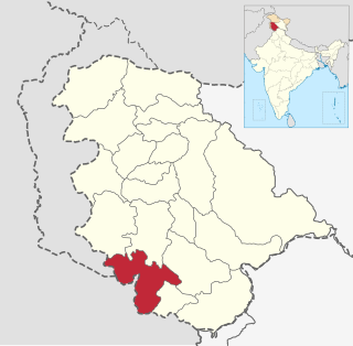
Jammu is the most populous of the districts of Jammu and Kashmir in India, and is home to the winter capital (Jammu) of Jammu and Kashmir. The capital moves to Srinagar city in the summer. The largest city is Jammu.
Pulwama is a city and a notified area council in Pulwama district, in India’s northern union territory of Jammu and Kashmir. It is almost 25 km (16 mi) from the summer capital of Srinagar. Pulwama is often called the "Anand of Kashmir", but also the "Dudha-Kul of Kashmir" on account of its high milk production.
Akhnoor is an archeological site and Municipal Committee in Jammu district in the union territory of Jammu and Kashmir, India. It is located at a distance of 28 km from Jammu, in the foothills of the Himalayas. The town is located on the banks of the Chenab River. The Akhnoor is divided into three Administrative Sub-Divisions - Akhnoor, Chowki Choura & Khour; Seven Tehsils - Akhnoor Khaas, Chowki Choura, Maira Mandrian, Jourian, Kharah Balli, Khour & Pargwal. Akhnoor is also divided into three Education Zones of Akhnoor, Khour & Chowki Choura.
{{Infobox settlement | name = Arnia | native_name = | native_name_lang = | other_name = | nickname = | settlement_type = City | image_skyline = | image_alt = | image_caption = | pushpin_map = India Jammu and Kashmir#India | pushpin_label_position = right | pushpin_map_alt = | pushpin_map_caption = Location in Jammu and Kashmir, India | coordinates = 32.52°N 74.8°E | subdivision_type = Country | subdivision_name = India | subdivision_type1 = State | subdivision_name1 = Jammu and Kashmir | subdivision_type2 = District | subdivision_name2 = Jammu | established_title = | established_date = | founder = | named_for = | government_type = | governing_body = | unit_pref = Metric | area_footnotes = | area_rank = | area_total_km2 = | elevation_footnotes = | elevation_m = 269 | population_total = 45890 | population_as_of = 2001 | population_rank = | population_density_km2 = auto | population_demonym = | population_footnotes = | demographics_type1 = Languages | demographics1_title1 = Spoken | demographics1_info1 = [[Dogri][Punjabi][Hindi]] | timezone1 = IST | utc_offset1 = +5:30 | postal_code_type = | postal_code = | registration_plate = | website = | footnotes = }} Arnia is a town and a notified area committee in Jammu district in the state of Jammu and Kashmir, India.
Bishnah is a town and a notified area committee in Jammu district in the Indian unon territory of Jammu and Kashmir.
Hajan is a town and a notified area committee in Bandipora district in the Indian state of Jammu and Kashmir.
Kunjer, or Kunzer, is a city in the Union Territory of Jammu and Kashmir, India. It is 7km from Gulmarg.
Pampore or Pampur is a town situated on the eastern side of river Jehlum on Srinagar-Jammu National Highway in the Indian union territory of Jammu and Kashmir. It is famous for its saffron, so-known as "Saffron Town of Kashmir". Pampore is one of the few places in the world where saffron, the world's most expensive spice, grows. The area is about 11 km from Srinagar city centre Lal Chowk. The postal code of the area is 192121. Areas Of Pampore are usually named as "Bal" as a prefix like localities of Namlabal, Kadlabal, Drangbal, Frestabal, Letrabal, Konibal etc. Pampore is also very famous for crispbread known as 'Shirmaal'. Pampore is also very famous for hospitality and it was also remarked as "Souni Pampar" which means "Golden Pampore" by Sheikh ul-Alam
Rajouri or Rajauri is a town in Rajouri district in the union territory of Jammu and Kashmir, India. It is located about 155 kilometres (96 mi) from Srinagar and 150 km from Jammu city on the Poonch Highway. The town is the location of Baba Ghulam Shah Badshah University and the birthplace of Sikh General Banda Singh Bahadur.
Ranbir Singh Pura is a constituency under jammu district notified area committee in Jammu district in the Indian Union territory of Jammu and Kashmir. It was the first planned city of J&K, that's why it is also known as Nawa-shehar. RS Pura is also one of the major producers of World's Famous Basmati Rice.

Reasi is a town and a notified area committee and tehsil in the Indian union territory of Jammu and Kashmir. Situated at the bank of River Chenab, it is the headquarters of the Reasi district. In the eighth century, Reasi was a part of the Bhimgarh state established by Bhim Dev. The name Reasi is derived from the town's old name "Rasyal".
Vijay Pur is a town and a notified area committee in Samba district in the Indian union territory of Jammu and Kashmir, situated on the bank of Devak river, known locally as Gupt Ganga. It is one of the most fast-growing towns near Jammu.
Poonch is the capital of Poonch district, in Jammu and Kashmir, India. It is located near the Line of Control – the de facto border with Pakistan's Azad Kashmir.
Ramnagar is both a town and a notified area committee in Udhampur District in the Indian union territory of Jammu and Kashmir.
Kangan is a town in Ganderbal district, of Jammu and Kashmir, India. It is one of the tehsils in Ganderbal District. It is situated across the Nallah Sindh and spread over a 50-km-long gorge valley, with population of 1,20,934 and literacy rate of 52.8% and sex ratio 868 per thousand males. It is one of the beautiful places surrounded by various picnic spots like Sonamarg and Naranag. It is believed that the place embraces its name with the fact that it is surrounded by mountains in all sides, gives it a ring shape, which is called in Hindi kangan.
Chowki Choura, Akhnoor, is a Sub-Division in Jammu district in the state of Jammu & Kashmir, India.

Jammu is the winter capital and the largest city in Jammu district of the Indian union territory of Jammu and Kashmir. Lying on the banks of the river Tawi, the city of Jammu, with an area of 26.64 km2 (10.29 sq mi), is surrounded by the Himalayas in the north and the northern-plains in the south. Jammu is the second most populous city of the union territory.

