Saltoro Valley

Last updated
Saltoro Valley
Geography
LocationBaltistan, Pakistan
Rivers Saltoro River
United Nations map of Siachen Glacier showing "Point NJ980420" (Point NJ9842) as the starting point of the "Actual Ground Position Line" (AGPL), Goma military camp of Pakistan, Nubra River valley and Siachen glaciers held by India, and Bilafond La and Sia La also held by India. Masherbrum Range, Baltoro Glacier, Baltoro Glacier, Baltoro Muztagh and K2 are held by Pakistan. Un-kashmir-jammu.png
United Nations map of Siachen Glacier showing "Point NJ980420" (Point NJ9842) as the starting point of the "Actual Ground Position Line" (AGPL), Goma military camp of Pakistan, Nubra River valley and Siachen glaciers held by India, and Bilafond La and Sia La also held by India. Masherbrum Range, Baltoro Glacier, Baltoro Glacier, Baltoro Muztagh and K2 are held by Pakistan.
UN map showing Siachen in white. Line between the green and white area is the "Actual Ground Position Line" (AGPL). The white area east of the AGPL is held by India. Kashmir Jammu Map.png
UN map showing Siachen in white. Line between the green and white area is the "Actual Ground Position Line" (AGPL). The white area east of the AGPL is held by India.
Indo-Pak mutually-agreed undisputed "International Border" (IB) in the black line, Indo-Pak "Line of Control" (LoC) in black dotted line in the north and west, Indo-Sino "Line of Actual" (LAC) in black dotted line in the east, Indo-Pak line across Siachen in north is "Actual Ground Position Line" (AGPL). The areas shown in green are the two Pakistani-controlled areas: Gilgit-Baltistan in the north and Azad Kashmir in the south. The area shown in orange is the Indian-controlled territories of Jammu and Kashmir, and Ladakh, and the diagonally-hatched area to the east is the Chinese-controlled area known as Aksai Chin. "Territories ceded by Pakistan to China claimed by India" in the north is Shaksgam (Trans-Karakoram Tract). Kashmir map.jpg
Indo-Pak mutually-agreed undisputed "International Border" (IB) in the black line, Indo-Pak "Line of Control" (LoC) in black dotted line in the north and west, Indo-Sino "Line of Actual" (LAC) in black dotted line in the east, Indo-Pak line across Siachen in north is "Actual Ground Position Line" (AGPL). The areas shown in green are the two Pakistani-controlled areas: Gilgit–Baltistan in the north and Azad Kashmir in the south. The area shown in orange is the Indian-controlled territories of Jammu and Kashmir, and Ladakh, and the diagonally-hatched area to the east is the Chinese-controlled area known as Aksai Chin. "Territories ceded by Pakistan to China claimed by India" in the north is Shaksgam (Trans-Karakoram Tract).

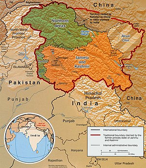
Saltoro valley is the highest valley in Pakistan and is located within the region of Baltistan. [1] This valley is under the administration of Pakistan and is situated near the Saltoro Mountain Range which includes the prominent Saltoro Kangri peak and the Saltoro River. Saltoro Valley is in proximity to the Siachen Glacier, which is the world's highest battleground and a disputed territory between India and Pakistan. [2] [3]

The Actual Ground Position Line (AGPL) divides the region held by India and Pakistan in the disputed Siachen area, running through the Saltoro Mountain Range. In this area, higher peaks and passes are held by India, while Pakistan occupies the lower peaks and valleys. [4] In 1984, India conducted Operation Meghdoot, capturing most of the contested Siachen area.

In April 1986, Pakistan launched an assault in the region and gained control of a high point south of Bilafond La, establishing a military post on this peak, which they named "Quaid Post" in honor of their leader,Quaid-e-Azam Muhammad Ali Jinnah. [2] [3] However, between June 23 and June 26, 1987, India initiated a counter-operation named Operation Rajiv, recapturing the post from Pakistan. They renamed it Bana Top, in tribute to Bana Singh, who had been awarded India's highest gallantry award, the Param Vir Chakra. [5] [3] [2]

See also

Near the AGPL (Actual Ground Position Line)
Borders
Conflicts
Operations
Other related topics

Related Research Articles

<span class="mw-page-title-main">Siachen Glacier</span> Glacier located in the eastern Karakoram range in the Himalayas

The Siachen Glacier is a glacier located in the eastern Karakoram range in the Himalayas at about 35.421226°N 77.109540°E, just northeast of the point NJ9842 where the Line of Control between India and Pakistan ends. At 76 km (47 mi) long, it is the longest glacier in the Karakoram and second-longest in the world's non-polar areas. It falls from an altitude of 5,753 m (18,875 ft) above sea level at its head at Indira Col on the India–China border down to 3,620 m (11,875 ft) at its terminus. The entire Siachen Glacier, with all major passes, has been under the administration of India as part of the union territory of Ladakh, located in the Kashmir region since 1984. Pakistan maintains a territorial claim over the Siachen Glacier and controls the region west of Saltoro Ridge, lying west of the glacier, with Pakistani posts located 1 km below more than 100 Indian posts on the ridge.

K12 is the second highest peak in the Saltoro Mountains, a subrange of the Karakoram range in the Siachen region of Ladakh. Its name comes from its designation given during the original survey of the Karakoram range. In 1984, an Indian army expedition under Colonel Prem Chand took hold of this peak, from the side of Siachen glacier by traversing from the west.

<span class="mw-page-title-main">Trans-Karakoram Tract</span> Chinese-administered area in the northern half of Kashmir near the Shaksgam River

The Trans-Karakoram Tract, also known as the Shaksgam Tract, is a disputed area of approximately 5,200 km2 (2,000 sq mi) north of the Karakoram watershed, including the Shaksgam valley. The tract is administered by China as part of its Taxkorgan and Yecheng counties in the Xinjiang Uyghur Autonomous Region. Although the Shaksgam tract was under the control of Pakistan since 1947, in the 1963 Sino-Pakistan Agreement, Pakistan recognized Chinese sovereignty over the Shaksgam tract, and a border based on actual ground positions was recognized as the international border by China and Pakistan. The Shaksgam Tract, along with the entire Kashmir region, is claimed by India.

<span class="mw-page-title-main">Operation Safed Sagar</span> 1999 Indian military operation

Operation Safed Sagar was the code name assigned to the Indian Air Force's role in acting jointly with the Indian Army during the 1999 Kargil war that was aimed at flushing out regular and irregular troops of the Pakistani Army from vacated Indian Positions in the Kargil sector along the Line of Control. It was the first large scale use of Airpower in the Jammu and Kashmir region since the Indo-Pakistani War of 1971.

<span class="mw-page-title-main">Saltoro Kangri</span> Mountain in disputed Kashmir region administered by India

Saltoro Kangri, previously known as Peak 36, stands as the highest peak within the Saltoro Mountains subrange, which is part of the larger Karakoram range. This subrange is also referred to as the Saltoro Range and is situated within the Karakoram region. The term "Saltoro Kangri" typically encompasses both of its twin peaks, Saltoro Kangri I and Saltoro Kangri II, which are connected by a saddle. When comparing heights, the generic term "Saltoro Kangri" is used for the taller of the two peaks, Saltoro Kangri I. This peak ranks as the 31st highest mountain globally and is located in the remote reaches of the Karakoram. It lies on the Actual Ground Position Line, dividing Indian-controlled territory in the Siachen region from Pakistani-controlled territory to the west of the Saltoro Range.

<span class="mw-page-title-main">Operation Meghdoot</span> 1984 Indian military operation in Kashmir

Operation Meghdoot was the codename for the Indian Army operation to take full control of the Siachen Glacier in Ladakh). Executed on the morning of 13 April 1984 in the highest battlefield in the world, Meghdoot was the first military offensive of its kind. This operation preempted Pakistan's Operation Ababeel; and was a success. Resulting in Indian forces gaining control of the Siachen Glacier in its entirety.

<span class="mw-page-title-main">Saltoro Mountains</span> Subrange of the Karakoram located on the southwestern side of the Siachen Glacier in Kashmir

The Saltoro Mountains form a subrange within the Karakoram Range and are situated in the southeastern part of the Karakoram. They lie on the southwest side of the Siachen Glacier, which is one of the two longest glaciers in the world outside the polar regions. The name "Saltoro" is also associated with the Saltoro Valley, located west of this range and descending on the Pakistani side of the Saltoro Range, which generally follows the Actual Ground Position Line (AGPL).

The Teram Kangri group is a mountain massif in the remote Siachen Muztagh, a subrange of the Karakoram range. The high point of the group, and of the Siachen Muztagh, is Teram Kangri I. The peak lies on the boundary between disputed China controlled Trans-Karakoram Tract and the disputed Siachen Glacier section controlled by India. The northeast side of the peak is in Chinese-controlled territory, the southwest side is controlled by India. Teram Kangri I was first climbed on August 10, 1975, by a Japanese expedition led by H. Katayama, which obtained a permit from the Government of Pakistan and made the long approach via Bilafond La. They climbed the SW ridge of Teram Kangri II and then took the East ridge to the top. Teram Kangri II was climbed on August 12 and 13 by six Japanese climbers.

<span class="mw-page-title-main">Ghent Kangri</span> Mountain in Pakistan/India

Ghent Kangri is a high peak near the north end of the Saltoro Mountains, a subrange of the Karakoram range. It is located west of the Siachen Glacier near the Actual Ground Position Line between India and Pakistan.

<span class="mw-page-title-main">Siachen conflict</span> 1984–2003 territorial conflict between India and Pakistan in Kashmir

The Siachen conflict, sometimes referred to as the Siachen Glacier conflict or the Siachen War, was a military conflict between India and Pakistan over the disputed 1,000-square-mile (2,600 km2) Siachen Glacier region in Kashmir. The conflict was started in 1984 by India's successful capture of the Siachen Glacier as part of Operation Meghdoot, and continued with Operation Rajiv in 1987. India took control of the 70-kilometre-long (43 mi) Siachen Glacier and its tributary glaciers, as well as all the main passes and heights of the Saltoro Ridge immediately west of the glacier, including Sia La, Bilafond La, and Gyong La. Pakistan controls the glacial valleys immediately west of the Saltoro Ridge. A cease-fire went into effect in 2003, but both sides maintain a heavy military presence in the area. The conflict has resulted in thousands of deaths, mostly due to natural hazards. External commentators have characterized it as pointless, given the perceived uselessness of the territory, and indicative of bitter stubbornness on both sides.

<span class="mw-page-title-main">Bilafond La</span> Mountain pass, Pakistan

Bilafond La (meaning "Pass of the Butterflies" in Balti language, also known as the Saltoro Pass, is a mountain pass situated on Saltoro Ridge, sitting immediately west of the vast Siachen Glacier, some 40 km directly north of map point NJ 980420 which defined the end of the 1972 Line of Control between Pakistan and India as part of the Simla Agreement. Bilafond La is on the ancient Silk Route linking the Indian Subcontinent and China.

<span class="mw-page-title-main">Sia La</span> Mountain pass in Ladakh

Sia La is a mountain pass situated on Saltoro Ridge, in Ladakh, India, some 60 km (37 mi) north-northwest of map point NJ9842 which defined the end of the 1972 Line of Control between India and Pakistan as part of the Simla Agreement. Sia La sits near the Chinese border and immediately northwest of the upper part of the vast Siachen Glacier, connecting that glacier to the Pakistani-controlled Kondus Glacier and valley to the west.

<span class="mw-page-title-main">Thoise Air Force Station</span> Village in Ladakh, India

Thoise or Thoise Air Force Station is a military airfield and small village in Nubra region of Ladakh, India, occupying the only large piece of flat land in the area. The airstrip is a critical facility enabling a quick inflow of men and material from the Indian interior to Siachen, a glacier, helipad and battleground near the Actual Ground Position Line between India and Pakistan.

<span class="mw-page-title-main">Gyong La</span>

Gyong La is a mountain pass situated on Saltoro Ridge southwest of the vast Siachen Glacier, some 20 km (12 mi) directly north of map point NJ9842 which defined the end of the 1972 Line of Control between India and Pakistan. With Pakistan controlling areas just to the west along Chumik Glacier, the immediate Gyong La area has been under India's control since 1989. Dozens of Indian military tents and other equipment are visible in 2013 and 2016 Google Earth imagery 100 meters east, 670 meters northeast, and 2.7 km east-northeast of Gyong La, linked by clear trails. Nearer the former Pakistani "Naveed Top" position and 3.85 km west-northwest of Gyong La is a post and helipad is visible in 2001 and 2016 Google Earth imagery at 5,800 m (19,000 ft) elevation, higher than both the Indian positions and Gyong La.

<span class="mw-page-title-main">Siachen Base Camp (India)</span>

Siachen Base Camp, 12,000 feet above sea level at Partapur, is a base camp of 102 Infantry Brigade of XIV Corps of Indian Army which protects 110 km long Actual Ground Position Line (AGPL) with at least 108 forward military outposts and artillery observation posts in the disputed region of Siachen Glacier in Ladakh Union Territory of India. It is approximately 6 hours drive north from the town of Leh via one of the highest vehicle-accessible passes in the world, Khardung La at 17,582 feet. Bana Top (20,500 ft) is the highest post in the region, which requires 80 km and 20 day trek for troops. Pahalwan Post and posts near Indira Col are other high posts. Kumar Post or Kumar Base, named after the Colonel Narendra "Bull" Kumar, serves as the battalion head quarter located 60 km from the Siachen base towards Indira Col. The Siachen Brigade consists of five to eight battalions of Ladakh Scouts supported by artillery, air defence, engineer and other logistic units. Pakistan has not been able to scale the crest of the Saltoro Range occupied by India. The temperature goes down to minus 86 °C during winters with icy 300 kmph blizzards. The average temperature is between minus 25 °C during day and minus 55 °C during the night.

<span class="mw-page-title-main">Actual Ground Position Line</span> Division line between Indian and Pakistani military posts on the Siachen Glacier in Kashmir

The Actual Ground Position Line (AGPL) divides current positions of Indian and Pakistani military posts and troops along the entire 110 kilometres (68 mi) long frontline in the disputed region of Siachen Glacier. AGPL generally runs along the Saltoro Mountains range, beginning from the northernmost point of the (LOC) at Point NJ 9842 and ending in the north on the Indira Ridge at the India-China-Pakistan LAC tripoint near Sia Kangri about 4 km (2.5 mi) northwest of Indira Col West, with peaks in excess of 7,000 m (23,000 ft) and temperatures ranging to around −55 °C (−67 °F). India gained control of 1,000 square miles (2,600 km2) of disputed territory in 1984 because of its military operations in Siachen. A cease-fire was announced in 2003.

<span class="mw-page-title-main">NJ9842</span> Point of military importance in Kashmir

NJ9842, also called NJ 980420, is the northernmost demarcated point of the India-Pakistan cease fire line in Kashmir known as the Line of Control (LoC). The India–Pakistan AGPL, begins from the NJ9842 on LoC and ends near the Indira Ridge at the trijunction of areas controlled by China, India, and Pakistan.

Indira Col West is a mountain pass at 5,988 metres (19,646 ft)) altitude on the Indira Ridge of Siachen Muztagh in Karakoram Range. It is on the border between Indian-controlled Siachen Glacier and the Chinese-controlled Trans-Karakoram Tract, close to the tripoint of India, Pakistan, and China. The India-Pakistan Actual Ground Position Line (AGPL) in the Siachen area ends near the pass. It is possible to ascend the pass from both the north and south sides controlled by China and India respectively.

<span class="mw-page-title-main">Chumik Glacier</span> Glacier in Pakistan

Chumik Glacier is located in the Siachen region, in Pakistan. Located on the west of Saltoro ridge, it is a 4-mile-long offshoot of the Bilafond Glacier.

Operation Rajiv was the codename for an Indian Army operation that aimed to capture a high point along the Actual Ground Position Line (AGPL) on the Siachen Glacier in June 1987. Prior to this operation, the area had been under the control of Pakistani forces, who had established a post on the peak, designated Quaid Post. Following India's successful capture of the peak, the post was renamed to Bana Top after Naib Subedar Bana Singh, who led the operation. Since Operation Rajiv in 1987, India continues to hold this post, which lies just to the south of the strategic Bilafond La mountain pass, also controlled by India. Alongside the higher-altitude installations, India has also established posts on the slopes at lower heights in this sector.

References

  1. "Saltoro Valley : Photo Albums : SummitPost".
  2. 1 2 3 Kunal Verma (2012). "XIV Op Rajiv". The Long Road to Siachen. Rupa. pp. 415–421. ISBN   978-81-291-2704-4.
  3. 1 2 3 Ajai Shukla (30 May 2011). "Army watches as Siachen dialogue resumes". Business Standard.
  4. How India realised it was at risk of losing the Siachen glacier to Pakistan, The Print, 12 April 2018.
  5. "Naib Subedar Bana Singh". Bharat Rakshak. Archived from the original on 5 March 2015. Retrieved 27 June 2014.