Nakur is a town, tehsil and a municipal board in Saharanpur district in the Indian state of Uttar Pradesh.

Shahjahanpur is a district of Uttar Pradesh India. It is a part of Bareilly division. It was established in 1813 by the British Government. Previously it was a part of district Bareilly. Geographically the main town is Shahjahanpur which is its headquarters. Its 4 Tehsils are: Powayan, Tilhar, Jalalabad and Sadar.

Sitapur district is one of the districts which is situated in Uttar Pradesh state of India, with Sitapur town as the district headquarters. Sitapur district is a part of Lucknow division.

Jind is one of the largest and oldest cities in Jind district in the Indian state of Haryana. It is the administrative headquarter of Jind district. Rani Talab is the main destination for tourists while Pandu Pindara and Ramrai are the main religious spots, attracting devotees for the holy bath during Amavasya.

Baheri is a city and municipality (nagarpalika) and tehsil in Bareilly district in the northern Indian state of Uttar Pradesh. It is 48 kilometres (30 mi) from Bareilly city, district headquarter. It is geographically located near the lower reaches of Gaula river. Located on the Highway connecting the Bareilly city to Nainital. The Town 300 kilometres (186 mi) north of the state capital, Lucknow, and 300 kilometres (186 mi) east of the national capital, New Delhi.
Bilsi is a town and a municipal board in Badaun district in the state of Uttar Pradesh, India. It is located to the southwest of Bareilly and has its own tehsil. According to Census 2011 information the sub-district code of Bilsi block is 00780. Total area of Bilsi is 361 km2 including 332.13 km2 rural area and 28.60 km2 urban area. Bilsi has a population of 4,04,198 peoples. There are 67,758 houses in the sub-district. There are about 204 villages in Bilsi bloc
Bisalpur is a City and a municipal board situated in the Pilibhit district of the state of Uttar Pradesh, India. The town is known for its sugar factory as well as its annual Ram Leela and Dushera festivals. Bisalpur is in between the two rivers, the West Doha River and the East Katna River. Before the formation of the new District Pilibhit, Bisalpur was under the District Bareilly. In 1913 AD after the formation of the new District Pilibhit, Bisalpur came under District Pilibhit Administration. this city is well connected with three major cities. Bisalpur is just 290 km away from the National capital New Delhi and 250 km from the state capital Lucknow. Bisalpur is famous for Annual Ramleela Fest, Dubey Taalab, Guleshwarnath Temple, Dargah Hazrat Gazi kamaal Degree college and Nagaich Market. Bisalpur is known for many things and places and the people of Bisalpur have contributed in various fields one such example is the Freedom fight Raees Mohammad who was a freedom fighter and a military man resident of Mohalla Gyaspur, he has won many medals for his extraordinary work he did for the country. He is well known for his charm and Character he played in the public domain now his generation resides in the Bisalpur mohalla gyaspur. Another important place is its railway station which has been modified for the broad gauge. This will help to get well connected with different cities of India..
Budhana is a town, block, tehsil, nagar panchayat, and one of the constituencies of the Uttar Pradesh Legislative Assembly in Muzaffarnagar district in Uttar Pradesh, India.
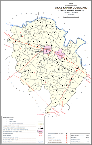
Gosainganj, also spelled Goshainganj or Gosaiganj is a town and nagar panchayat in Lucknow district of Uttar Pradesh, India. It is the seat of a community development block, which is included in the tehsil of Mohanlalganj. As of 2011, its population is 9,649, in 1,685 households. The starting point of the Purvanchal Expressway i.e. Chand Saray village is situated 2.5 km away from Gosainganj.
Narauli is a town and a nagar panchayat in Sambhal district in the Indian state of Uttar Pradesh.
Parsadepur, also spelled Parshadepur, is a town and a nagar panchayat in Rae Bareli district in the Indian state of Uttar Pradesh. It is located on the north bank of the Sai river, at the crossroads between the road from Salon to Jais and the smaller road from Raebareli to Ateha. Historically noted for its large weaving industry, Parsadepur served as the headquarters of a pargana since the late 18th century. As of 2011, its population is 11,853 people, in 1,738 households.

Purwa is a town and nagar panchayat in Unnao district, Uttar Pradesh, India. It is located 32 km southeast of Unnao, the district headquarters. Roads connect it with several major cities including Unnao, Lucknow, Kanpur, and Rae Bareli. As of 2011, its population is 24,467 people, in 4,128 households.
Shergarh is a town and a nagar panchayat in Bareilly district in the Indian state of Uttar Pradesh. It is a small town known for rice and sugarcane.
Sunam is a town and a tehsil, near city of Sangrur in Sangrur district in the Indian state of Punjab. The Railway Station of Sunam was renamed as Sunam Udham Singh Wala.

Ujhani is an industry-based city and a municipal board in Badaun district in the Indian state of Uttar Pradesh.
Faridpur is a town and a small Nagar Palika and tehsil in Bareilly district in the Indian state of Uttar Pradesh. Faridpur is known for zari work. It comes under 122 Legislative assembly. Current M.L.A. is Professor Shyam Bihari Lal and M.P. is Mr. Dharmendra Kashyap. Nagarpalika Chairman of Faridpur is Mr Sharaf Zari Wale
Pali is a town and nagar panchayat in Sawayajpur tehsil of Hardoi district, Uttar Pradesh, India. It is on the right bank of the Garra river, 20 miles northwest of Hardoi, Pali historically served as the seat of a pargana and was a regional political headquarters under the Nawabs of Awadh. The town's name is possibly connected to the Pal dynasty that once ruled the nearby city of Kannauj. As of 2011, the population of Pali is 18,708 in 2,949 households.

Barwala is a town situated 30 km northeast of Hisar city. It is one of the 4 sub-division of Hisar district in the state of Haryana, India.
Sainthal is a nagar panchayat in Nawabganj tehsil, Bareilly district, Uttar Pradesh, India.

Inhauna is a village and corresponding in Singhpur block of Rae Bareli district, Uttar Pradesh, India. As of 2011, its population is 13,049, in 2,021 households. Located at the junction of the Raebareli-Rudauli and Lucknow-Jaunpur roads, Inhauna is an old town that once served as the seat of a pargana as well as (briefly) a tehsil, and it has the ruins of an old fort built under the Nawabs of Awadh. The old marketplace, known as Ratanganj, was built in 1863 by the tahsildar Ratan Narain. Markets are held twice per week, on Mondays and Thursdays, and most of the trade is in livestock.

