Firozabad district

Last updated

Firozabad district
Firozabad UP 2.jpg
Jain temple in Firozabad
India Uttar Pradesh districts 2012 Firozabad.svg
Location of Firozabad district in Uttar Pradesh
Coordinates(Firozabad): 27°09′06″N78°24′06″E / 27.1518°N 78.4016°E / 27.1518; 78.4016
CountryIndia
State Uttar Pradesh
Division Agra
Headquarters Firozabad
Government
   District Magistrate Dr. Ujjwal Kumar (IAS) [1]
   Lok Sabha constituencies Firozabad
Area
  Total2,407 km2 (929 sq mi)
Population
 (2023)
  Total3,472,437 [2]
Demographics
   Literacy 74.6%. [3]
Time zone UTC+05:30 (IST)
Major highways NH 19
Website http://firozabad.nic.in/

Firozabad district is one of the western districts of the Indian state of Uttar Pradesh, which has Firozabad city as its district headquarters. The district is a part of the Agra division.

Contents

History

The city lies in the cultural region of Braj and was a part of the Surasena Mahajanapada during the Vedic Age. It was subsequently ruled by the bigger kingdoms like the Mauryas, Guptas, Scythians, Kushans, Indo-Greeks before falling into the hands of local Rajput and Jat rulers. [4]

It was named after Firoz Shah Mansab Dar in 1566 during the reign of Mughal Emperor akbar. The 1596 gazetteer of Agra and Mathura records that Firozabad was upgraded to a Pargana then given to Nabab Sadulla as a jagir during the reign of Shah jahan (r. 16271658). Mr. Peter, a businessman, connected with the East India Company visited the town on 9 August 1632 and found it in good condition. Etawah, Budaun, Mainpuri and Firozabad were all first class mansabdars of the emperor Farrukhsiyar (r. 17131719). The estate of the Labhowa Jhala Hindu Rajas were subdued during the Mughal sultanate which captured many regions in the United Provinces, and by 1680 the Rajas of Labhowa lost control of Firozabad district.

Bajirao Peshwa captured Firozabad and Etmadpur in 1737 in the regime of Mohammad Shah. Jat Rulers from Mahawan attacked Faujdar Hakim Kajim at Firozabad where they killed him on 9 May 1739, then went on to rule Firozabad for 30 years. Firozabad was also part of Bharatpur Kingdom.Gajuddin, Hidayat Vaksh (son of Alamgir II), his nephew and Mirza Baba his son in law, looted Firozabad. Mirza Nabab Khan stayed here until 1782. At the end of 18th century Firozabad was ruled by Himmat Bahadur Gusain with the cooperation of the Raja of Labhowa.

The French Army Chief Marathas D. Wayan established an ordnance factory in Firozabad in November 1794, an event that Thomas Traving mentions in his book Travels in India. Marathas appointed his subadar Lakwadads here who built a fort near the old tehsil. General Lek and General Vellajally attacked Firozabad in 1802. At the beginning of the British regime Firozabad was in the Etawah district and later attached to the Aligarh district. When Sadabad district was created in 1832, Firozabad was made a part of it then later in 1833 the town came under the aegis of Agra district. In 1847 the lakh business flourished in Firozabad.[ clarification needed ]

In 1857, the freedom–fighting Chauhans of Mainpuri, the Jamidar of Chandwar and the local Malahs all took active parts in the Indian Rebellion. Noted Urdu poet Munir Shikohabadi was sentenced to Kala pani by the ruling East India Company. People from this city took part in the Khilafat Movement, the Quit India Movement and the Dandi March with some participants jailed. Mahatma Gandhi visited Firozabad 1929 followed by Semant Gandhi in 1935, Pandit Jawaharlal Nehru in 1937 and Netaji Subhas Chandra Bose in 1940.

Firozabad district was established on February 4, 1989 by an executive order passed by the Government of Uttar Pradesh. Previously, the areas had been part of Agra district and Mainpuri district. [5] :3

Demographics

Historical population
YearPop.±% p.a.
1901520,466    
1911501,357−0.37%
1921464,114−0.77%
1931487,700+0.50%
1941580,115+1.75%
1951666,941+1.40%
1961821,189+2.10%
19711,034,964+2.34%
19811,279,726+2.15%
19911,555,685+1.97%
20012,081,752+2.96%
20112,498,156+1.84%
20212,959,000+1.71%
source: [6]
Religions in Firozabad district (2011) [7]
ReligionPercent
Hinduism
85.69%
Islam
12.60%
Jainism
0.76%
Other or not stated
0.95%
Distribution of religions

According to the 2011 census Firozabad district has a population of 2,498,156, [3] roughly equal to the nation of Kuwait [8] or the US state of Nevada. [9] This gives it a ranking of 173rd in India (out of a total of 640). [3] The district has a population density of 1,044 inhabitants per square kilometre (2,700/sq mi) . [3] Its population growth rate over the decade 2001-2011 was 21.62%. [3] Firozabad has a sex ratio of 867 females for every 1000 males, [3] and a literacy rate of 74.6%. 33.35% of the population lives in urban areas. Scheduled Castes make up 18.97% of the population. [3]

Languages of Firozabad district (2011) [10]

   Hindi (97.03%)
   Urdu (2.60%)
  Others (0.37%)

At the time of the 2011 Census of India, 97.03% of the population in the district spoke Hindi and 2.60% Urdu as their first language. The local language of the district is Brajbhasha. [10]

Firozabad is a primarily rural district, with 66.6% of the population living in rural areas and 33.4% living in urban areas as of 2011. At the sub-district level, this is reversed in the case of Firozabad tehsil, where 63.2% of the population lives in urban areas. [5] :26

Amenities

All the following tables are as of 2011.

Drinking water

The following table shows how households get their main source of drinking water: [11] :232–3

Source of drinking waterRuralUrbanTotal
Tap water (treated source)9.4%34.9%18.1%
Tap water (untreated source)4.0%12.3%6.8%
Well (covered or uncovered)1.34%0.42%1.02%
Hand pump81.3%11.5%57.5%
Tube well/borehole3.3%38.4%15.25%
All others0.67%2.62%1.34%

Lighting

The following table shows how households get their main source of lighting: [11] :234–5

Type of lightingRuralUrbanTotal
Electricity29.3%82.9%47.6%
Kerosene69.4%15.1%50.9%
Solar0.31%0.32%0.32%
Other oil0.49%0.32%0.44%
All others0.24%0.56%0.35%
No lighting0.3%0.84%0.48%

Toilets

The following table shows how households mainly go to the bathroom: [11] :236–7

ToiletRuralUrbanTotal
Flush/pour toilet, connected to sewer system1.6%16.4%6.6%
Flush/pour toilet, connected to septic tank 6.3%58.5%24.1%
Other flush/pour toilet1.0%2.0%1.3%
Pit latrine, with slab/ventilated improved1.8%2.2%1.9%
Pit latrine, without slab/open0.38%0.96%0.58%
Night soil (disposed of by self or others)0.42%2.12%1.01%
No toilet at home, use public toilets instead0.9%1.6%1.1%
Open defecation 87.7%16.3%63.3%

Possessions

The following table sorts households by whether they have the following possessions: [11] :242–3

ItemRuralUrbanTotal
Radio10.6%10.1%10.4%
Television28.2%66.0%41.2%
Computer (with internet)0.6%3.1%1.4%
Computer (without internet)5.3%8.3%6.3%
Cell phone63.3%64.4%63.7%
Bicycle73.9%55.1%67.5%
Scooter/motorcycle/moped18.6%24.8%20.7%
Car1.8%4.3%2.7%
None of the above10.7%11.1%10.9%

Culture

The city have some popular Hindu temples mainly Vaishno Devi Dham, Kela Devi Temple, Gopal Ashram (Hanuman Temple). There are many Jain temples in Firozabad including the well-known Chadamilal Jain temple, Shri Shuparshnath Jain Mandir in Gher Khokal (Mahaveer Chowk) and Chandprabhu Jain Mandir in Khidki. The two temples of Gherkhokal and Khidki are approximately 250300 years old. The old name of Chandwar was taken from the idol of Chandprabhu made at the time of Prithviraj Chauhan. Muhammad of Ghor attacked a holy Jain location situated 6 kilometres (3.7 mi) from Firozabad 19 times. An annual fair was held in Chandwar on October 2 . The Jama Masjid, founded by the 16th century Mughal Emperor Akbar is the oldest mosque.

Notable people

Education

University

Geography

The district borders Etawah district to the north and Mainpuri and Etawah to the east with the Yamuna River forming the southern boundary. The area of the district accounts for about 0.8 per cent of the total area of Uttar Pradesh and 1.1 per cent its population. Approximately 73.6 percent of people live in rural areas. Most of the district lies on a plain sloping from north west to south.

Transportation

Firozabad district has good transportation links due to National Highway 19 linking Delhi with Kolkata & Yammuna Express Way passing through it as does the busy railway route from Delhi to Kolkata. Agra is 44 km (27 mi) away, Kanpur is 250 km (160 mi) away, Delhi is 250 km (160 mi) away.

Nearest Airport is in Agra which is a domestic Airport

Nearest Railway station is Firozabad railway station in the center of Firozabad and one in Tundla named as Tundla Junction.

Local industries

Firozabad has a major glass industry producing products that include glass bangles and glass hardware so it is also known as Suhag Nagari.[ clarification needed ] Various work is done on bangles in many places known locally as godam.

Administration

Firozabad district is divided into 4 tehsils and 9 community development blocks, as follows: [5] :4

Municipalities

Firozabad district has 6 statutory towns, including 4 nagar palika parishads (municipal boards) and 2 nagar panchayats. There are also 3 non-statutory census towns in the district. The district's towns are as follows: [5] :4,321–3,325

Town nameClassificationTehsilPopulation (in 2011)
Tundla Nagar palika parishad Tundla50,423
Tundla Railway Colony Census town Tundla7,404
Tundla Kham Census town Tundla7,079
Firozabad Nagar palika parishad Firozabad604,214
Fariha Nagar panchayat Jasrana6,887
Jasrana Nagar panchayat Jasrana10,648
Shikohabad Nagar palika parishad Shikohabad107,404
Sirsaganj Nagar palika parishad Shikohabad32,098
Makhanpur Census town Shikohabad7,012

Villages

Related Research Articles

<span class="mw-page-title-main">Etawah</span> City in Uttar Pradesh, India

Etawah, also known as Ishtikapuri, is a city on the banks of Yamuna River in the state of Western Uttar Pradesh in India. It is the administrative headquarters of Etawah District. Etawah's population of 256,838 makes it the 180th most populous city in India. The city lies 300 km (190 mi) southeast of the national capital New Delhi, 230 km (140 mi) northwest of the state capital Lucknow, 120 km east of Agra and 140 km west of Kanpur. The city was an important centre for the Indian Rebellion of 1857. It is also the sangam or confluence of the Yamuna and Chambal rivers. It is the 26th most populous city in Uttar Pradesh.

Mainpuri is a city in Mainpuri district in the Indian state of Uttar Pradesh. It is the administrative headquarters of Mainpuri district and is situated to the north-east of Agra and is 270 km from New Delhi. Mainpuri is located in the Braj region, which holds special religious significance to Hindus as the homeland of Krishna.

<span class="mw-page-title-main">Firozabad</span> City in Uttar Pradesh, India

Firozabad is a city near Agra in Firozabad district in the state of Uttar Pradesh in India. It is the centre of India's glassmaking industry and is known for the quality of the bangles and glassware produced here.

<span class="mw-page-title-main">Agra district</span> District in Uttar Pradesh, India

Agra is one of the 75 districts in the northern Indian state of Uttar Pradesh. The district headquarters is the historical city of Agra. Agra district is a part of Agra division.

<span class="mw-page-title-main">Etah district</span> District of Uttar Pradesh in India

Etah district is one of the districts of Uttar Pradesh, India, since 1854. Etah City is the district headquarters. Etah district is a part of Aligarh Division.

<span class="mw-page-title-main">Etawah district</span> District of Uttar Pradesh in India

Etawah district is one of the districts in the western portion of Uttar Pradesh state of India. Etawah town is the district headquarters. The district covers an area of 2311 km2. It has a population of 1,581,810.

<span class="mw-page-title-main">Mainpuri district</span> District of Uttar Pradesh in India

Mainpuri district is one of the districts in the Agra division of Uttar Pradesh, India. Mainpuri town is the district headquarters. It consists of six tehsils, namely Mainpuri, Bhongaon, Karhal, Kishni, Kurawali and Ghiror.

<span class="mw-page-title-main">Kannauj district</span> District of Uttar Pradesh in India

Kannauj district is an administrative district of Uttar Pradesh state in northern India, along the river Ganges. The historic town of Kannauj, northwest of Kanpur, is the administrative center. The district was carved out of Farrukhabad district on 18 September 1997. The native dialect of this district is Kannauji.

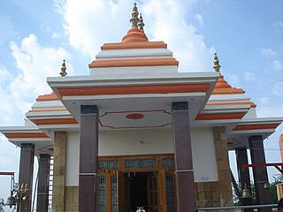
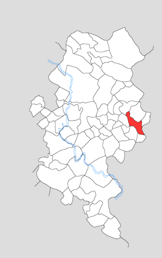
Ghiror, also spelled Ghiraur, is a town and a nagar panchayat in Mainpuri district in the state of Uttar Pradesh, India. It is also the headquarters of a community development block comprising 74 villages. As of 2011, Ghiror has a population of 15,911, in 2,687 households.

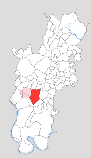
Karhal is a town and Nagar Panchayat in Mainpuri district in the Indian state of Uttar Pradesh. It is also a tehsil that is subdivided into two blocks, Karhal and Barnahal. It is one of the Vidhan Sabha constituency of Uttar Pradesh.

Shikohabad is a city and a municipal board in the Firozabad district of the Indian state of Uttar Pradesh.

<span class="mw-page-title-main">Tundla</span> Town in Uttar Pradesh, India

Tundla is a town and a municipal board in Firozabad district in the Indian state of Uttar Pradesh. It is an important railway junction between the Delhi-Kanpur main line and the Agra branch line. Tundla is a railway town that sprang up when the railway was built in the late 1800s. It is served by Tundla Junction railway station. As of 2011, Tundla has a population of 50,423 people, in 8,744 households.

Eka is a town in Jasrana Tehsil, pincode 283152 Firozabad district, Uttar Pradesh, India.

<span class="mw-page-title-main">Shikohabad Junction railway station</span> Railway station in Uttar Pradesh, India

Shikohabad Junction railway station is on the Kanpur-Delhi section of Howrah–Delhi main line and Howrah–Gaya–Delhi line. It is located in Firozabad district in the Indian state of Uttar Pradesh. It serves Shikohabad.

<span class="mw-page-title-main">Saifai</span> Village in Uttar Pradesh, India

Saifai is a large village and university town in the Etawah district of the Indian state of Uttar Pradesh. It is also a sub-division (Tehsil) and Block of the Etawah district. It is the birthplace of Mulayam Singh Yadav, the founding president of the Samajwadi Party, former Minister of Defence in India, and former Chief Minister of Uttar Pradesh.

<span class="mw-page-title-main">Jarkhi</span> Village in Uttar Pradesh, India

Jarkhi is a village in Tundla block of Firozabad district, Uttar Pradesh. As of 2011, it has a population of 1,468, in 262 households. Jarkhi was historically the capital of a taluqdari estate held by a Jat family and comprising 41 villages. It was also known for its prosperous Jain community and its export trade in shoes and ghee.

Bewar is a town and nagar panchayat in Bhongaon tehsil of Mainpuri district, Uttar Pradesh. Historically the seat of a pargana and tehsil, it today serves as the seat of a community development block. As of 2011, Bewar had a population of 23,729, in 4,202 households.

<span class="mw-page-title-main">Nagla Dal</span> Village in Uttar Pradesh, India

Nagla Dal is a village in Tundla block of Firozabad district, Uttar Pradesh, India. As of 2011, it had a population of 2,471, in 383 households.

<span class="mw-page-title-main">Nagla Sikandar</span> Village in Uttar Pradesh, India

Nagla Sikandar is a village in Tundla block of Firozabad district, Uttar Pradesh. As of 2011, it has a population of 3,083, in 468 households.

<span class="mw-page-title-main">Kotla, Firozabad</span> Village in Uttar Pradesh, India

Kotla is a village and community development block in Firozabad tehsil of Firozabad district, Uttar Pradesh. Located by a small stream called the Sengar, it was historically the seat of a prominent zamindari estate. As of 2011, Kotla had a population of 3,331, in 604 households.

References

  1. "DM Profile | District Firozabad, Government of Uttar Pradesh | India".
  2. As per UIDAI data in 2023
  3. 1 2 3 4 5 6 7 "District Census Handbook: Firozabad" (PDF). censusindia.gov.in. Registrar General and Census Commissioner of India. 2011.
  4. "Census of India 2001: Data from the 2001 Census, including cities, villages and towns (Provisional)". Census Commission of India. Archived from the original on 16 June 2004. Retrieved 1 November 2008.
  5. 1 2 3 4 "Census of India 2011: Uttar Pradesh District Census Handbook - Firozabad, Part A (Village and Town Directory)" (PDF). Census of India. Retrieved 19 June 2023.
  6. Decadal Variation In Population Since 1901
  7. "Table C-01 Population by Religion: Uttar Pradesh". censusindia.gov.in. Registrar General and Census Commissioner of India. 2011.
  8. US Directorate of Intelligence. "Country Comparison:Population". Archived from the original on 26 December 2018. Retrieved 1 October 2011. Kuwait 2,595,62
  9. "2010 Resident Population Data". U. S. Census Bureau. Archived from the original on 19 October 2013. Retrieved 30 September 2011. Nevada 2,700,551
  10. 1 2 "Table C-16 Population by Mother Tongue: Uttar Pradesh". www.censusindia.gov.in. Registrar General and Census Commissioner of India.
  11. 1 2 3 4 "Census of India 2011: Uttar Pradesh District Census Handbook - Firozabad, Part B (Village and Town Wise Primary Census Abstract)" (PDF). Census of India. Retrieved 19 June 2023.