Badami Bagh is a cantonment town on the outskirts of Srinagar district in the Indian state of Jammu & Kashmir. A portion of Indian army in the valley resides in the Badami Bagh cantonment. The cantonment is established on the two road sides of Srinagar Jammu National Highway.

Bina Railway Colony is a census town in Sagar District of state of Madhya Pradesh in India.
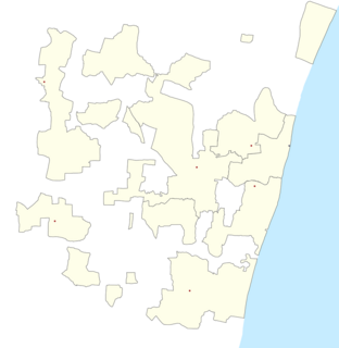
Kurumbapet is a town and a gram panchayat in Pondicherry district in the Indian union territory of Puducherry.

Lumding Railway Colony is a census town in Hojai district in the Indian state of Assam.

Melagaram is a panchayat town in Tenkasi taluk, Tirunelveli district, in the Indian state of Tamil Nadu.
Narasimhanaickenpalayam is a part of Coimbatore city. It is about 14 km from Coimbatore city junction in the northern direction. Narasimhanaickenpalayam is on the stretch of National Highway NH 67 Extn (NH-181) Mettupalayam Road, one of the arterial roads of Coimbatore city. Neighbouring places are Thudiyalur, NGGO Colony, and Periyanaickenpalayam

Naspur is a suburb and mandal in Mancherial district of the Indian state of Telangana.
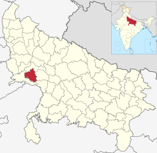
Northern Railway Colony is a census town in Kanpur Nagar district in the Indian state of Uttar Pradesh.

Qasimpur Power House Colony is a census town in Aligarh district in the Indian state of Uttar Pradesh. It was established for the employees of Harduaganj Thermal Power Station. It is situated on Aligarh-Moradabad highway at a distance of 16 km from Aligarh and 40 km from Khair.
Ratlam Railway Colony, also known as Ratlam Kasba, is a census town in Ratlam District in the Indian state of Madhya Pradesh.It stretches from Dat ki Pul to the Railway hospital. The colony ends at Gandhinagar and the railway station on the opposite side. It is home to two railway schools, a full-sized basketball court, a full-size track and field ground and a volleyball court. The colony boasts two clubs with badminton courts and pool table.

{{Infobox settlement | name = Raybag | other_name = Raibag | nickname = Bagi ur | settlement_type = town/taluka | image_skyline = | image_alt = | image_caption = | pushpin_map = India Karnataka#India | pushpin_label_position = right | pushpin_map_alt = | pushpin_map_caption = Location in Karnataka, India | coordinates = 16.48°N 74.78°E | subdivision_type = Country | subdivision_name = India | subdivision_type1 = State | subdivision_name1 = Karnataka | subdivision_type2 = District | subdivision_name2 = Belgaum | established_title = | established_date = | founder = | named_for = | government_type = | governing_body = Nagar Palika | unit_pref = Metric | area_footnotes = | area_rank = | area_total_km2 = | elevation_footnotes = | elevation_m = 590 | population_total = 18,984 | population_as_of = 2011 | population_rank = | population_density_km2 = auto | population_demonym = | population_footnotes = | demographics_type1 = Languages | demographics1_title1 = Official | demographics1_info1 = [[ಕನ್ನಡ][Kannada]] | timezone1 = IST | utc_offset1 = +5:30 | postal_code_type = | postal_code = 591317 | registration_plate = KA23 | website = karnataka.gov.in | iso_code = IN-KA | footnotes = }} Raybag is a panchayat town and taluka in Belgaum district in the Indian state of Karnataka. It derives its name from the two words namely "Raya'' and "bagh" in which "Raya'' means king and "bagh" means tiger.

Sabathu is a cantonment town in Solan district in the Indian state of Himachal Pradesh.
Sankar Nagar is a panchayat town in Tirunelveli district in the Indian state of Tamil Nadu.
Shaktinagar is a census town in Raichur district in the Indian state of Karnataka. There is a coal-based thermal power plant set up by Karnataka Power Corporation Limited (KPCL).
Tundla is a town and a municipal board in Firozabad district in the Indian state of Uttar Pradesh. It is located 24 km away from Agra city.
Tundla Kham is a census town in Firozabad district in the Indian state of Uttar Pradesh.

Weir is a town and a municipality in Bharatpur District in the Indian state of Rajasthan.
Bagh is a census town in Dhar district in the state of Madhya Pradesh, India. It is known for the Bagh Caves, which are late 4th- to 6th-century Buddhist rock-cut chambers with murals. The name of the town stems from the caves - according to local legend there were living tigers in these abandoned Buddhist caves.
Boda is a town and a Nagar panchayat in Rajgarh district in the state of Madhya Pradesh, India. The main language spoken in Boda is Hindi, along with Malvi.
Samboora or Sombur is a District and a notified area committee in Samboora district in the Indian administered part of the state of Jammu and Kashmir.