Sirsaganj

Last updated

Sirsaganj
सिरसागंज
town
India Uttar Pradesh location map.svg
Red pog.svg
Sirsaganj
Location in Uttar Pradesh, India
Coordinates: 27°03′25″N78°41′10″E / 27.05694°N 78.68611°E / 27.05694; 78.68611
CountryFlag of India.svg  India
State Uttar Pradesh
District Firozabad
Elevation
162 m (531 ft)
Population
 (2011)
  Total28,212(14,926 males 13,286 females) [1]
Hindi
  Official Hindi
Time zone UTC+5:30 (IST)
PIN
205151/283151

Sirsaganj is a town and a municipal board in Firozabad district in the Indian state of Uttar Pradesh.

Sirsaganj is a Vidhan Sabha (Legislative Assembly) constituency of the State of Uttar Pradesh in India. (AC No. 99). ""Smt Ranjana Singh"" is Chairmen of Nagar Palika Parishad, Sirsaganj and Shri Sarvesh Yadav is MLA of Sirsaganj.In the town of Sirsaganj, there live 4,404 families constituting a population of 28,212 persons. There live 14,926 males and 13,286 females in Sirsaganj. The sex ratio of Sirsaganj is 887.98 females per 1000 males.

Hinduism is the main religion here. Muslims, Jains, and Sikhs are in minorities. In Hindus, Kirar Thakurs are in majority. This area is mainly inhabited by Yadav and also has a significant population of Sengar and Jadon Rajputs (Kirar) . Kirar of sirsaganj are descended from Karauli state via Avagarh state . Spiritual culture of this city is defined as a nearby radius of 5–10 km like Hanumaan Bari, Samor Baba, Jaimai Mata Mandir, Jaduwara, Radha Krishna Mandir, Shri Shakleshwar Mahadev, Shri Vankhandeshwar and Baba Dudhadhari Mandir. [2]

Generally, people of Sirsaganj mainly speak Braj Bhasha which is a dialect of Hindi. People also speak standard Hindi. Many people in the town also have fluency in English. There are also a few speakers of Urdu and Punjabi.

Farming and shopkeeping is the main occupation of the people of Sirsaganj. In Sirsaganj there also live a large number of businesspeople, servicemen, lawyers, and teachers.most of the people are related to agriculture, and potato is the main crop here.

People of the town are generally treated as prospers. But there also live a large number of people under the poverty line. However, this town is considered a peaceful residence. It has a rich culture where people are conservative. A large number of people wear traditional clothes.

Geography

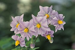
Flowers of a potato plant Potato flowers.jpg
Flowers of a potato plant
Russet potatoes with sprouts Russet potato cultivar with sprouts.jpg
Russet potatoes with sprouts
Wheat Wheat P1210892.jpg
Wheat

Sirsaganj is located at 27°03′25″N78°41′10″E / 27.05694°N 78.68611°E / 27.05694; 78.68611 . [3]

Some Main Roads of Sirsaganj are Kaurara Road, Araon Road, Paigu Road, Kunjpura Road, Sothra Road, Karhal Road, and Etawah Road which can be called as "Lifeline of Sirsaganj" because it's economical and geographical importance, all the major businesses, shops, and showrooms are on this road and this road connects to all the previously mentioned roads!

Sirsaganj is 80 km away from the major metropolitan city of Agra, which is an international travel destination. The other major cities close to Sirsaganj are Firozabad (34 Km), Etawah (47 Km)

Related Research Articles

<span class="mw-page-title-main">Etawah</span> City in Uttar Pradesh, India

Etawah, also known as Ishtikapuri, is a city on the banks of Yamuna River in the state of Western Uttar Pradesh in India. It is the administrative headquarters of Etawah District. Etawah's population of 256,838 makes it the 180th most populous city in India. The city lies 300 km (190 mi) southeast of the national capital New Delhi, 230 km (140 mi) northwest of the state capital Lucknow, 120 km east of Agra and 140 km west of Kanpur. The city was an important centre for the Indian Rebellion of 1857. It is also the sangam or confluence of the Yamuna and Chambal rivers. It is the 26th most populous city in Uttar Pradesh.

Mainpuri is a city in Mainpuri district in the Indian state of Uttar Pradesh. It is the administrative headquarters of Mainpuri district and is situated to the north-east of Agra and is 270 km from New Delhi. Mainpuri is located in the Braj region, which holds special religious significance to Hindus as the homeland of Krishna.

<span class="mw-page-title-main">Firozabad</span> City in Uttar Pradesh, India

Firozabad is a city near Agra in Firozabad district in the state of Uttar Pradesh in India. It is the centre of India's glassmaking industry and is known for the quality of the bangles and glassware produced here.

<span class="mw-page-title-main">Etah district</span> District of Uttar Pradesh in India

Etah district is one of the districts of Uttar Pradesh, India, since 1854. Etah City is the district headquarters. Etah district is a part of Aligarh Division.

<span class="mw-page-title-main">Etawah district</span> District of Uttar Pradesh in India

Etawah district is one of the districts in the western portion of Uttar Pradesh state of India. Etawah town is the district headquarters. The district covers an area of 2311 km2. It has a population of 1,581,810.

<span class="mw-page-title-main">Firozabad district</span> District of Uttar Pradesh in India

Firozabad district is one of the western districts of the Indian state of Uttar Pradesh, which has Firozabad city as its district headquarters. The district is a part of the Agra division.

<span class="mw-page-title-main">Mainpuri district</span> District of Uttar Pradesh in India

Mainpuri district is one of the districts in the Agra division of Uttar Pradesh, India. Mainpuri town is the district headquarters. It consists of six tehsils, namely Mainpuri, Bhongaon, Karhal, Kishni, Kurawali and Ghiror.

<span class="mw-page-title-main">Bhind district</span> District of Madhya Pradesh in India

Bhind district is a district in the Chambal division of the Indian state of Madhya Pradesh. It share border of Morena, Gwalior and Etawah The town of Bhind is the district headquarters.Bhind District is situated in Chambal region in the northwest of the state.

<span class="mw-page-title-main">Bhadohi district</span> District in Uttar Pradesh, India

Bhadohi district is a district of Uttar Pradesh state in northern India. It is also referred to as Sant Ravidas Nagar. It is the smallest district by area in the state of Uttar Pradesh which was created on June 30, 1994 by dividing western part of the district Varanasi. It is surrounded by Varanasi district on east, Allahabad on west, Jaunpur north and Mirzapur district in south. The state capital Lucknow is distanced at 234 KM from Bhadohi. Its district headquarters is situated in the city of Gyanpur. The district is popularly known for carpet weaving as it is one of largest centres of Carpet Industries in India and therefore it also known as the 'Carpet City of India'. Carpets of Bhadohi have 'Geographical Indication' tag attached to it. Bhadohi has huge geographical significance and position attached to it due to its location between two culturally important and rich heritage cities of Prayagraj and Varanasi.

Bakewar is a town and a nagar panchayat in Etawah district in the state of Uttar Pradesh, India. It is 22 km from district headquarters Etawah. Bakewar is famous for its very good education system, Agriculture Training Institute and for National highway no. 2. Bakewar is situated at national highway no. 2. It is between Agra and Kanpur, the two biggest cities of Uttar Pradesh. Agra is 145 km north and Kanpur is 135 km on south of Bakewar. Bharthana is the nearest railway (11 km) of Bakewar, situated in the east.

Behta Hajipur is a census town in the Loni block of Ghaziabad district in the Indian state of Uttar Pradesh. It is a part of the National Capital Region (NCR). At one end (southwest), the town's boundary terminates at National Highway 709B, which connects Delhi to Saharanpur, and at the other end (northeast), the boundary ends at Loni-Ghaziabad Road. It also share its territories with the neighboring census town, Mandoli.

Kora Jahanabad is a town in Fatehpur district and in Indian state of Uttar Pradesh. It is located on Kora Road, about 6 km east of Jahanabad, about 43 km south of Kanpur, 78 km west by northwest of Fatehpur, and 480 km southeast of Delhi. Local people also call it "Jahanabad".

<span class="mw-page-title-main">Musafirkhana</span> Town in Uttar Pradesh, India

Musafirkhana is a town and tehsil in Amethi district in Indian state of Uttar Pradesh. The word "Musafirkhana" means "Sarai," or "Dharamshala". Musafirkhana is located 32 km northwest of district headquarters Amethi.

Shikohabad is a city and a municipal board in the Firozabad district of the Indian state of Uttar Pradesh.

<span class="mw-page-title-main">Bateshwar, Uttar Pradesh</span> Village in Uttar Pradesh, India

Bateshwar is a village in Agra District, on the banks of the river Yamuna in the northern state of Uttar Pradesh, India. Bateshwar is in between Agra and Etawah and is 8 km from Bah. It is an important spiritual and cultural centre for Hindus and Jains. It is known for the 101 Shiv Temple Complex. An annual religious and animal fair is also organised in the village ground area.

Aryapur Khera is the village. Mainpuri city is an administrative headquarters of this village. Mainpuri is located to the north-east of Agra.

<span class="mw-page-title-main">Daryaoganj</span> Town in Uttar Pradesh, India

Daryaoganj is a town situated in Kasganj district of Uttar Pradesh state in India. Daryaoganj comes under the Majhola Gram Panchayat, its Vidhan Sabha Region & Block is Patiyali and the Lok Sabha Region is Etah. The Postal Index Number of Daryaoganj is 207244 and comes under Patiyali postal region. The holy river Ganga passes about 12 km away from this town.

<span class="mw-page-title-main">Sirsaganj Assembly constituency</span> Constituency of the Uttar Pradesh legislative assembly in India

Sirsaganj Assembly constituency is one of the 403 constituencies of the Uttar Pradesh Legislative Assembly, India. It is a part of the Firozabad district and one of the five assembly constituencies in the Firozabad Lok Sabha constituency. First election in this assembly constituency was held in 2012 after the "Delimitation of Parliamentary and Assembly Constituencies Order, 2008" was passed and the constituency was formed in 2008. The constituency is assigned identification number 99. The constituency has major population of Yadav and Rajput communities with significant population of other communities also.

<span class="mw-page-title-main">Saifai</span> Village in Uttar Pradesh, India

Saifai is a large village and university town in the Etawah district of the Indian state of Uttar Pradesh. It is also a sub-division (Tehsil) and Block of the Etawah district. It is the birthplace of Mulayam Singh Yadav, the founding president of the Samajwadi Party, former Minister of Defence in India, and former Chief Minister of Uttar Pradesh.

Gothawn is a town located in the Azamgarh district of Uttar Pradesh, India. It comes under the Martinganj subdistrict There are three main religions Hinduism, Buddhism and Islam. International Buddhist Temple is the most important place here. It was founded by Venerable Chandrajeet Gautam.

References