Jhansi district

Last updated

Jhansi district
Rani Mahal Jhansi.jpg
Dance of the Aqua - Flickr - Dr. Santulan Mahanta.jpg
India Uttar Pradesh districts 2012 Jhansi.svg
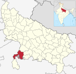
Location of Jhansi district in Uttar Pradesh
CountryFlag of India.svg  India
State Uttar Pradesh
Division Jhansi
Headquarters Jhansi
Tehsils 1. Jhansi, 2. Mauranipur, 3. Moth, 4.Tehroli, 5.Garautha
Government
   Lok Sabha constituencies Jhansi
Area
  Total5,024 km2 (1,940 sq mi)
Population
 (2011)
  Total1,998,603
  Density400/km2 (1,000/sq mi)
   Urban
833,484
Demographics
   Literacy 75.05%
  Sex ratio890
Time zone UTC+05:30 (IST)
Website jhansi.nic.in

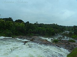
Jhansi district is one of the districts of Uttar Pradesh state in northern India. The city of Jhansi is the district headquarters. The district is bordered on the north by Jalaun District, to the east by Hamirpur and Mahoba districts, to the south by Tikamgarh District of Madhya Pradesh state, to the southwest by Lalitpur District, which is joined to Jhansi District by a narrow corridor, and on the east by the Datia and Bhind districts of Madhya Pradesh. Population 19,98,603 (2011 census). Lalitpur District, which extends into the hill country to the south, was added to Jhansi District in 1891, and made a separate district again in 1974.

Contents

History

Jhansi Junction railway station Jhansi Junction.jpg
Jhansi Junction railway station

In 1861 the city of Jhansi and a dependent territory was ceded to Gwalior State and the capital of the district was moved to Jhansi-Nawabad (Jhansi Re-founded), a village without "cantonment" (military camp). Jhansi (the old city) became the capital of a "subah" (provínce) within the state of Gwalior, but in 1886 was returned to British rule as a district of the United Provinces of Agra and Oudh in exchange for the Gwalior Fort and the cantonment of Morar nearby. [1] (It had been given to the Maharaja of Gwalior, but came under British rule in 1886 as the result of a territorial swap.) The population of Jhansi in 1901 was about 55,000 while Jhansi district's population had been about 407,000 in 1891. [1]

Under the Mughal Empire at the time of Akbar, the area of today's Jhansi district was part of the sarkar of Erachh in Agra Subah. [2] The area was part of the mahals of Erachh, Bhander, Bijpur, Jhansi, "Pandor" (i.e. Pandwaha), and Jhatra. [2] Jhatra consisted of 4 mahals grouped together. [2]

Geography

Several railway lines serve the district. South of Jhansi District lies the hill country of Bundelkhand, which slopes down from the Vindhya Range. The district consists of the level plain of Bundelkhand, distinguished for its deep black soil, known as mar, and admirably adapted for the cultivation of cotton. The district is intersected or bounded by three principal rivers, the Pahuj, Betwa and Dhasan.

The main city in Jhansi district is Jhansi. Other towns are Mauranipur, Garautha, Moth, Babina, Chirgaon, Samthar Gursarai Erich, etc.

Demographics

Historical population
YearPop.±% p.a.
1901426,875    
1911468,327+0.93%
1921421,828−1.04%
1931477,544+1.25%
1941535,878+1.16%
1951565,933+0.55%
1961714,484+2.36%
1971870,138+1.99%
19811,137,031+2.71%
19911,429,698+2.32%
20011,744,931+2.01%
20111,998,603+1.37%
source: [3]
Religions in Jhansi district (2011) [4]
ReligionPercent
Hinduism
91.26%
Islam
7.40%
Other or not stated
1.34%
Distribution of religions

According to the 2011 census Jhansi district has a population of 1,998,603, [5] roughly equal to the nation of Slovenia [6] or the US state of New Mexico. [7] This gives it a ranking of 231st in India (out of a total of 640). [5] The district has a population density of 398 inhabitants per square kilometre (1,030/sq mi) . [5] Its population growth rate over the decade 2001-2011 was 14.54%. [5] Jhansi has a sex ratio of 890 females for every 1000 males, [5] and a literacy rate of 69.68%. 41.70% of the population lives in urban areas. Scheduled Castes and Scheduled Tribes make up 28.14% and 0.19% of the population respectively. [5]

Languages of Jhansi district (2011) [8]

   Hindi (95.35%)
   Bundeli (3.36%)
  Others (1.29%)

At the time of the 2011 Census of India, 95.35% of the population in the district spoke Hindi and 3.36% Bundeli as their first language. [8]

District at a Glance

Tehsil

There are 5 tehsil in district Jhansi: [9]

  1. Jhansi
  2. Mauranipur
  3. Garautha
  4. Tehroli
  5. Moth

Development Blocks

There are 8 Development Blocks: [9]

  1. Babina
  2. Badagaon
  3. Bamaur
  4. Bangra
  5. Chirgaon
  6. Gursarai
  7. Mauranipur
  8. Moth

Constituencies

There are 4 constituencies in Jhansi District: [9]

  1. 222 – Babina
  2. 223 – Jhansi Nagar
  3. 224 – Mauranipur
  4. 225 – Garautha

Villages

Related Research Articles

<span class="mw-page-title-main">Babina, Uttar Pradesh</span> City in Uttar Pradesh, India

Babina is a cantonment town in Jhansi district in the state of Uttar Pradesh, India. Shree Rajeev Singh Parichha is MLA of Babina constituency.

<span class="mw-page-title-main">United Provinces of Agra and Oudh</span> Province in British India

The United Provinces of Agra and Oudh was a province of India under the British Raj, which existed from 22 March 1902 to 1937; the official name was shortened by the Government of India Act 1935 to United Provinces (UP), by which the province had been commonly known, and by which name it was also a province of independent India until 1950.

<span class="mw-page-title-main">Lalitpur, India</span> City in Uttar Pradesh, India

Lalitpur is a city and a municipal board in Lalitpur District, India in the Indian state of Uttar Pradesh. It is also district headquarters of Lalitpur district. The city is part of Bundelkhand region.

<span class="mw-page-title-main">Jhansi</span> Metropolis in Uttar Pradesh, India

Jhansi is a historic city in the Indian state of Uttar Pradesh. Balwant Nagar was the old name of Jhansi. It lies in the region of Bundelkhand, on the banks of the Pahuj River, in the extreme south of Uttar Pradesh. Jhansi is the administrative headquarters of Jhansi district and Jhansi division. Also called the Gateway to Bundelkhand, Jhansi is situated near and around the rivers Pahuj and Betwa at an average elevation of 285 m (935 ft). It is about 420 kilometres (261 mi) from national capital New Delhi and 315 kilometres (196 mi) from state capital Lucknow.

<span class="mw-page-title-main">Datia</span> City in Madhya Pradesh, India


Datia is the district headquarter of the Datia District in north central Madhya Pradesh,a state of Central India. It is an ancient town, mentioned in the Mahabharata ruled by King Dantavakra. The city is 78 km from Gwalior, 325 km south of New Delhi and 344 km north of Bhopal. About 18 km from Datia is Sonagiri, a sacred Jain hill. Datia is also about 31 km from Jhansi and 52 km from Orchha. The nearest airport is at Gwalior. It was formerly the seat of the eponymous princely state in the British Raj. Datia is situated near Gwalior and on the border with Uttar Pradesh.

<span class="mw-page-title-main">Sultanpur district</span> District of Uttar Pradesh in India

Sultanpur district is a district in the Awadh region of the Indian state of Uttar Pradesh. This district is a part of Ayodhya division of the state. The administrative headquarters of the district is Sultanpur city. The total area of Sultanpur district is 2672.89 Sq. km.

<span class="mw-page-title-main">Tikamgarh</span> City in Madhya Pradesh, India

Tikamgarh is a town and a tehsil in Tikamgarh district in the Indian state of Madhya Pradesh. The city serves as a district headquarters. The earlier name of Tikamgarh was Tehri consisting of three hamlets, forming a rough triangle. In Tikamgarh town there is locality still known as 'Purani Tehri'. Until Indian independence in 1947, Tikamgarh, formerly called Tehri, was part of the kingdom of Orchha, which was founded in the 16th century by the Bundeli chief Rudra Pratap Singh, who became the first King of Orchha. In 1783 the capital of the state was moved to Tehri, about 40 miles (64 km) south of Orchha, which was home to the fort of Tikamgarh, and the town eventually took the name of the fort. The district is famous for the old fort of Kundar known as Garh Kundar, which was built by Khangars and remained the capital of Khangar rulers from 1180 to 1347.

<span class="mw-page-title-main">Agra district</span> District in Uttar Pradesh, India

Agra is one of the 75 districts in the northern Indian state of Uttar Pradesh. The district headquarters is the historical city of Agra. Agra district is a part of Agra division.

<span class="mw-page-title-main">Bijnor district</span> District of Uttar Pradesh in India

Bijnor district is one of the 75 districts in the state of Uttar Pradesh in India. Bijnor city is the district headquarters. The government of Uttar Pradesh seeks its inclusion in National Capital Region (NCR) due to its close proximity to NCT of Delhi.

<span class="mw-page-title-main">Jalaun district</span> District of Uttar Pradesh in India

Jalaun district is a district of Uttar Pradesh, India. The district is named after the town of Jalaun, which was the former headquarters of a Maratha governor, but the administrative headquarters of the district is at Orai.

<span class="mw-page-title-main">Datia district</span> District of Madhya Pradesh in India

Datia District is in Gwalior Division in the Indian state of Madhya Pradesh. The town of Datia is its district headquarters.

<span class="mw-page-title-main">Bhind district</span> District of Madhya Pradesh in India

Bhind district is a district in the Chambal division of the Indian state of Madhya Pradesh. The town of Bhind is the district headquarters.Bhind District is situated in Chambal region in the northwest of the state. It is surrounded by Agra, Etawah, Jalaun and Jhansi districts of Uttar Pradesh state to the north and the east, and the Madhya Pradesh districts of Datia to the south, Gwalior to the southwest, and Morena to the west. The geography of the district is characterised by uneven ravines, plain fertile fields and scanty forests. The total area of the district is 4,459 km2 (1,722 sq mi).

<span class="mw-page-title-main">Tikamgarh district</span> District of Madhya Pradesh in India

Tikamgarh district is one of the 52 districts of Madhya Pradesh state in central India. Tikamgarh town is the district headquarters. The district is part of Sagar Division.

<span class="mw-page-title-main">Lalitpur district, India</span> District in Uttar Pradesh, India

Lalitpur is one of the 75 districts in the northern Indian state of Uttar Pradesh. Lalitpur district is a part of Jhansi Division. Lalitpur is the main town and administrative headquarters. The district occupies an area of 5,039 km2.

Mauranipur is a town and a municipal board in Jhansi district state of Uttar Pradesh, India. It is located in the Jhansi District. It is the largest tehsils in India by land area. This town was known for textile production, known in ancient times as Madhupuri. Because of its high density of temples, it is known by some locals as Mini-Ayoddhya. Jalvihar Mela and Viman Yatra are the most famous events in Mauranipur. The Kedareshwar temple and the Saprar Dam are located near Mauranipur.

<span class="mw-page-title-main">Chanderi District</span>

Chanderi District was a former administrative district of British India. It covered most of present-day Lalitpur district of Uttar Pradesh state and the eastern portion of Ashoknagar District of Madhya Pradesh state.

Chirgaon is a town and a municipal board in Jhansi district in the Indian state of Uttar Pradesh, India.

Garautha is a Tehsil and a Nagar Panchayat city in district of Jhansi, Uttar Pradesh. The Garautha City is divided into 10 wards for which elections are held every 5 years. Garautha is 80 and 36 km away from Jhansi and Tahrauli. There is also tehseel headquarter. Garautha is a largest Tahseel of Jhansi District. There are some religious places near Garautha as Jharkhand dham,Hanuman mandir,lathator dham ashram.

Rajakhera is a city and a municipality situated near the banks of the Chambal River in Dholpur district in the Eastern part of the Indian state of Rajasthan. Its part of Braj region and the local language has Braj Bhasha dialect. The culture is fused with Rajasthan and its border states.

The Sahariya are a community found in the Bundelkhand region of North India, which is administered by the states of Madhya Pradesh and Uttar Pradesh. They are also known as Rawat, Banrawat, Banrakha and Soarain.

References

  1. 1 2 "Dschansi". Meyers Grosses Konversations-Lexikon. September 1905. Retrieved 18 November 2012.
  2. 1 2 3 Drake-Brockman, D.L. (1929). Jhansi: A Gazetteer, Being Volume XXIV Of The District Gazetteers Of The United Provinces Of Agra And Oudh. Allahabad: Government Press. pp. 191–2. Retrieved 3 May 2021.
  3. Decadal Variation In Population Since 1901
  4. "Table C-01 Population by Religion: Uttar Pradesh". censusindia.gov.in. Registrar General and Census Commissioner of India. 2011.
  5. 1 2 3 4 5 6 "District Census Handbook: Jhansi" (PDF). censusindia.gov.in. Registrar General and Census Commissioner of India. 2011.
  6. US Directorate of Intelligence. "Country Comparison:Population". Archived from the original on 13 June 2007. Retrieved 1 October 2011. Slovenia 2,000,092 July 2011 est.
  7. "2010 Resident Population Data". U. S. Census Bureau. Archived from the original on 19 October 2013. Retrieved 30 September 2011. New Mexico - 2,059,179
  8. 1 2 "Table C-16 Population by Mother Tongue: Uttar Pradesh". www.censusindia.gov.in. Registrar General and Census Commissioner of India.
  9. 1 2 3 Jhansi

25°30′N78°30′E / 25.500°N 78.500°E / 25.500; 78.500