Dabethuwa

Last updated

Dabethuwa
Village
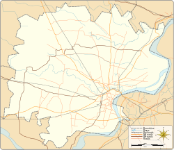
Varanasi district location map.svg
Red pog.svg
Dabethuwa
Village location on Varanasi district map
India Uttar Pradesh location map.svg
Red pog.svg
Dabethuwa
Dabethuwa (Uttar Pradesh)
India location map.svg
Red pog.svg
Dabethuwa
Dabethuwa (India)
Coordinates: 25°20′33″N82°41′39″E / 25.342560°N 82.694242°E / 25.342560; 82.694242 Coordinates: 25°20′33″N82°41′39″E / 25.342560°N 82.694242°E / 25.342560; 82.694242
CountryFlag of India.svg  India
State Uttar Pradesh
Elevation
85 m (279 ft)
Population
 (2011)
  Total757
Languages
  Official Hindi
Time zone UTC+5:30 (IST)
Postal code
221207
Telephone code +91-542
Vehicle registration UP65 XXXX
Village code209148
Website up.gov.in

Dabethuwa is a village in Varanasi tehsil of Varanasi district in the Indian state of Uttar Pradesh. It is about 294 kilometres from the state capital Lucknow and 776 kilometres from the national capital Delhi. [1] [2] [3] [4]
Contents

Demography

Dabethuwa has a total population of 757 people amongst 106 families. Sex ratio of Dabethuwa is 897 and child sex ratio is 1,034. Uttar Pradesh state average for both ratios is 912 and 902 respectively [note] . [2]

DetailsMaleFemaleTotalComments
Number of houses106(census 2011) [2]
Adult340297637
Children (0–6 years)5961120
Total population399358757
Literacy89.12%70.71%80.53%

Transportation

Dabethuwa can be accessed by road only as it does not have a railway station. Closest railway station to this village is Bhadohi (23 km). Nearest operational airports are Varanasi airport (38 kilometres) and Allahabad Airports (114 kilometres). [5]

See also

Notes

Related Research Articles

Aily is a village in Varanasi district in the Indian state of Uttar Pradesh. It is about 316 kilometres from the state capital Lucknow and 812 kilometres from the national capital Delhi.

Aitha is a village in Varanasi district in the Indian state of Uttar Pradesh. It is about 312 kilometers from the state capital Lucknow and 806 kilometers from the national capital Delhi.

Chadpur is a village in Varanasi tehsil, Varanasi district in the Indian state of Uttar Pradesh. It is about 324 kilometers from the state capital Lucknow and 812 kilometers from the national capital Delhi.

Eshipur is a village in Pindra Tehsil of Varanasi district in the Indian state of Uttar Pradesh. Eshipur has its own gram panchayat in the same name as the village. The village is about 27 kilometers North-West of Varanasi city, 284 kilometers South-East of state capital Lucknow and 802 kilometers South-East of the national capital Delhi.

Kathiraon is a village in Pindra Tehsil of Varanasi district in the Indian state of Uttar Pradesh. Kathiraon has its own gram panchayat in the same name as the village. The village is about 45 kilometres north-west of Varanasi city, 269 kilometres south-east of state capital Lucknow and 778 kilometres south-east of the national capital Delhi.

Adhkatiya Kala Khas is a village in Pindra Tehsil of Varanasi district in the Indian state of Uttar Pradesh. Adhkatiya Kala Khas falls under the Tilvar gram panchayat. The village is about 34 kilometers North-West of Varanasi city, 280 kilometers South-East of state capital Lucknow and 783 kilometers South-East of the national capital Delhi.

Ajaipur is a village in Pindra Tehsil of Varanasi district in the Indian state of Uttar Pradesh. Ajaipur has its own gram panchayat by the same name as the village. The village is about 31.0 kilometers North-West of Varanasi city, 263 kilometers South-East of state capital Lucknow and 800 kilometers South-East of the national capital Delhi.

Amaut is a village in Pindra Tehsil of Varanasi district in the Indian state of Uttar Pradesh. Amaut has its own gram panchayat by the same name as the village. The village is about 30 kilometres north-west of Varanasi city, 269 kilometres south-east of state capital Lucknow and 807 kilometres south-east of the national capital Delhi.

Araji Hasanpur is a village in Pindra Tehsil of Varanasi district in the Indian state of Uttar Pradesh. Araji Hasanpur falls under Madhomakhiya gram panchayat. The village is about 34.5 kilometers North-West of Varanasi city, 308 kilometers South-East of state capital Lucknow and 784 kilometers South-East of the national capital Delhi.

Murdi is a village in Pindra Tehsil of Varanasi district in the Indian state of Uttar Pradesh. Murdi has its own gram panchayat by the same name as the village. The village is about 23 kilometers north-west of Varanasi city, 314 kilometers south-east of state capital Lucknow and 809 kilometers south-east of the national capital Delhi.

Gaag Khurd is a village in Pindra Tehsil of Varanasi district in the Indian state of Uttar Pradesh. Only one shia Muslim Village between Varanasi and Jaunpur District. The village comes under Gangkala gram panchayat. The village is about 27 kilometers North-West of Varanasi city, 266 kilometers South-East of state capital Lucknow and 791 kilometers South-East of the national capital Delhi.

Ausanpur is a village in Pindra Tehsil of Varanasi district in the Indian state of Uttar Pradesh. The village has gram panchayat by the same name as the village. The village is about 16 kilometers North-West of Varanasi city, 320 kilometers South-East of state capital Lucknow and 796 kilometers South-East of the national capital Delhi. The village is situated on the banks of River Varuna. The famous Panchkoshi Road lies on the North side of the village.

Azoarepur is a village in Pindra Tehsil of Varanasi district in the Indian state of Uttar Pradesh. The village falls under the Sarvipur gram panchayat. The village is about 39 kilometres northwest of Varanasi city, 284 kilometres southeast of the state capital Lucknow, and 789 kilometres southeast of the national capital Delhi.

Babatpur is a village, near Varanasi city in Pindra Tehsil of Varanasi district in the Indian state of Uttar Pradesh. The village falls under gram panchayat by the same name as the village. The village also houses Lal Bahadur Shastri Airport which serves Varanasi district. The village is about 26 kilometers North-West of Varanasi city, 260 kilometers South-East of state capital Lucknow and 797 kilometers South-East of the national capital New Delhi.

Basni is a village in Pindra Tehsil of Varanasi district in the Indian state of Uttar Pradesh. The village falls under gram panchayat by the same name as the village. The village is about 26 kilometres North-West of Varanasi city, 262 kilometres South-East of state capital Lucknow and 794 kilometres South-East of the national capital Delhi.

Bachaura is a village in Pindra Tehsil of Varanasi district in the Indian state of Uttar Pradesh. The village falls under gram panchayat by the same name as the village. The village is about 34 kilometers North-West of Varanasi city, 273 kilometers South-East of state capital Lucknow and 794 kilometers South-East of the national capital Delhi.

Salarpur is a census town in Varanasi tehsil of Varanasi district in the Indian state of Uttar Pradesh. The census town & village falls under the Salarpur gram panchayat. Salarpur Census town & village is about 8 kilometres North-East of Varanasi railway station, 329 kilometres South-East of Lucknow and 4 kilometres South-East of Sarnath.

Birbhanpur is a census town in Varanasi tehsil of Varanasi district in the Indian state of Uttar Pradesh. The census town & village falls under the Virbhan Pur gram panchayat. Birbhanpur Census town & village is about 18 kilometres South-West of Varanasi railway station, 306 kilometres South-East of Lucknow and 21 kilometres North-West of Banaras Hindu University.

Umaraha is a census town in Varanasi tehsil of Varanasi district in the Indian state of Uttar Pradesh. The census town & village falls under the Umaraha gram panchayat. Umarha Census town & village is about 12 kilometers North-East of Varanasi railway station, 317 kilometers South-East of Lucknow and 17 kilometers North-East of Banaras Hindu University main gate.

Dindaspur is a census town in Varanasi tehsil of Varanasi district in the Indian state of Uttar Pradesh. The census town & village falls under the Dindaspur gram panchayat. Dindaspur Census town & village is about 18 kilometres west of Varanasi railway station, 310 kilometres south-east of Lucknow and 25 kilometres north-west of Banaras Hindu University main gate.

References

  1. "Village coordinates". latlong.net. Archived from the original on 7 August 2017. Retrieved 1 February 2015.
  2. 1 2 3 "Population & General info". 2011 census. Retrieved 1 February 2015.
  3. "Village code:2011". Village info. Retrieved 1 February 2015.
  4. "PIN Code". villagemap.in. Retrieved 1 February 2015.
  5. "Rail information". indiarailinfo.com. Retrieved 1 February 2015.