The district is named after its headquarters, Tikamgarh. The original name of the town was Tihri. In 1783, the ruler of Orchha Vikramajit (1776–1817) shifted his capital from Orchha to Tihri and renamed it Tikamgarh (Tikam is one of the names of Krishna).
History
The area covered by this district was part of the Princely State of Orchha till its merger with the Indian Union. The Orchha state was founded by Rudra Pratap Singh in 1501. After merger, it became one of the eight districts of Vindhya Pradesh state in 1948. Following the reorganization of states on 1 November 1956 it became a district of the newly carved Madhya Pradesh
Orchha was founded some times after 1501 AD,[1] by the Bundela chief, Rudra Pratap Singh, who became the first King of Orchha, (r. 1501–1531) and also built the Fort of Orchha.[2] He died in an attempt to save a cow from a lion. The Chaturbhuj Temple was built, during the time of Akbar, by the Queen of Orchha,[3] while Raj Mandir was built by 'Madhukar Shah' during his reign, 1554 to 1591.[4][5]
During the rule of Mughal Emperor, Jahangir, his ally, Vir Singh Deo (r. 1605–1627) reigned here, and it was during this period that Orchha reaches its height, and many extant palaces are a reminder of its architectural glory, including Jahangir Mahal (born c. 1605) and Sawan Bhadon Mahal.[6]
In the early 17th century, Raja Jhujhar Singh rebelled against the Mughal emperor Shah Jahan, whose armies devastated the state and occupied Orchha from 1635 to 1641. Orchha and Datia were the only Bundela states not subjugated by the Marathas in the 18th century. The town of Tehri, now Tikamgarh, about 52 miles (84km) south of Orchha, became the capital of Orchha state in 1783, and is now the district town; Tehri was the site of the fort of Tikamgarh, and the town eventually took the name of the fort.[7]
Hamir Singh, who ruled from 1848 to 1874, was elevated to the style of Maharaja in 1865. Maharaja Pratap Singh (born 1854, died 1930), who succeeded to the throne in 1874, devoted himself entirely to the development of his state, himself designing most of the engineering and irrigation works that were executed during his reign.
In 1901, the state had an area of 2,000sqmi (5,200km2), and population of 52,634. It was the oldest and highest in rank of all the Bundela states, with a 17-gun salute, and its Maharajas bore the hereditary title of First of the Prince of Bundelkhand. Vir Singh, Pratap Singh's successor, merged his state with the Union of India on January 1, 1950. The district became part of Vindhya Pradesh state, which was merged into Madhya Pradesh state in 1956. Today Orchha is almost a nondescript town with a small population, and its importance is maintained only due to its rich architectural heritage and tourism.
Books on the rich history of Orchha are available in local shops, mostly in the Hindi language. Only a thorough reading of some of this material will tell about the rich and varied history of this place.
Economy
In 2006 the Ministry of Panchayati Raj named Tikamgarh one of the country's 250 most backward districts (out of a total of 640).[8] It is one of the 24 districts in Madhya Pradesh receiving funds from the Backward Regions Grant Fund Programme (BRGF).[8] The economy of this area mainly based on agriculture and allied activities.
Tikamgarh is a major player in producing pyrophyllite. There are various pyrophyllite mining sites where high-quality pyrophyllite stone is getting mined. The pyrophyllite of Tikamgarh is getting exported to all over India.
Demographics
Tikamgarh district of Madhya Pradesh has a total population of 1,445,166 as per the Census 2011. Out of which 760,355 are males while 684,811 are females. In 2011 there were total of 296,116 families residing in Tikamgarh district. The Average Sex Ratio of Tikamgarh district is 901.
As per Census 2011 out of the total population, 17.3% of people live in Urban areas while 82.7% live in the rural areas. The average literacy rate in urban areas is 74.7% while that in the rural areas is 58.6%. Also, the Sex Ratio of Urban areas in Tikamgarh district is 909 while that of Rural areas is 899. The population of Children age 0–6 years in Tikamgarh district is 227564 which is 16% of the total population. There are 120303 male children and 107261 female children between the ages of 0–6 years. Thus as per the Census 2011, the Child Sex Ratio of Tikamgarh is 892 which is less than the Average Sex Ratio (901) of Tikamgarh district. The total literacy rate of Tikamgarh district is 61.43%. The male literacy rate is 60.41% and the female literacy rate is 42.14% in Tikamgarh district.
The bifurcated district had a population of 1,040,359, of which 170,655 (16.40%) lived in urban areas. Tikamgarh had a sex ratio of 901 females per 1000 males. Schedule Castes and Scheduled Tribes make up 262,163 (25.20%) and 49,613 (4.77%) of the population respectively.[9]
At the time of the 2011 census, 84.94% of the population spoke Bundeli and 14.61% Hindi as their first language.[11]
Festivals
Moniya Dance in Bundelkhand is performed every year during the festival of light Diwali/Deepawali at the end of October or the first week of November according to the lunar calendar. In this connection, the epic story goes that “in Gokul” when Lord Krishna raised Govardhan Mountain on his finger to save his associates (milkmen), they danced in joy. The main instruments used in this dance are ‘Dholak’ and ‘Nagaria’ (both being a form of drums). The male dancers with long sticks show the martial arts when the beats of drums inspire their energy and emotions. This dance is also performed as a ‘thanksgiving’ after harvesting. The dancers wear multi-colored apparel and the chief dancer holds the peacock feathers in his hands and the rest stick those feathers in their half pants.
Cuisines
Tikamgarh is famous for mawa filled ras bhariya gujiyas. You have drooled over the tempting gujiyas on every occasion, especially on Holi. With an extra dose of sweetness and flavors, this Chashni wali gujiya is pure bliss and a great hit amongst everyone.
Hospital facilities
Rajendra Prasad District Hospital
Govt. Ayurvedic Dispensary
Ayush Wing – District Hospital
Life line Nursing Home
Sudha Sevalaya Nursing Home
Education
Schools
Government Excellence Higher Secondary School, Tikamgarh
Government Excellence Higher Secondary School, Jatara
Government Excellence Higher Secondary School, Palera
Government Higher Secondary School, Tikamgarh, No-2
Jawahar Navodaya Vidhyalaya Tikamgarh
Kendriya Vidyalaya Tikamgarh
Model Higher Secondary School, Tikamgarh
Pushpa High School Tikamgarh
Saroj Convent Higher Secondary School Tikamgarh
Unique Educational Academy School Tikamgarh
Angels Abode Public School
HAROKRISHNAN CHEW SCHOOL
Colleges / universities
College of Agriculture, Tikamgarh
District Institute of Education and Training, Kundeshwar
Govt Law College Tikamgarh
Govt P G College Tikamgarh
Govt College, Lidhoura
Govt College, Mohangarh
Govt College, Lidhoura
Govt Virangana Avanti Bai Girls College, Tikamgarh
ITI-Tikamgarh, District – Tikamgarh
ITI-Baldeogarh, District – Tikamgarh
Polytechnic College, Tikamgarh
Polytechnic College, Jatara
Communication
Postage stamps of this feudatory state were prepared for use in 1897 but were never issued. First Orchha State stamps were issued in 1913. Separate stamps were discontinued on 30 April 1950 after the state was merged with the Union of India early that year.
Transportation
Tikamgarh has the biggest bus stand in Madhya Pradesh.
Welcome gate at Jhansi Road In TKG
Roads
There are daily services of buses for every part of the state. Highways Passing from Tikamgarh are NH-12A, SH-10.
Tikamgarh railway station is in the North Central Railway Zone. Its Railway code is TKMG. The construction of the railway line to Tikamgarh has been completed in 2012. On 26 April 2013 was connected with railway services. The rail services began from Lalitpur(Uttar Pradesh) to Tikamgarh and were started under the Lalitpur-Singrauli Rail Project. The first train to travel between the two stations was Tikamgarh-Jhansi(Uttar Pradesh) passenger train. The train was sanctioned between the two stations in the Rail Budget of 2012–13. The railway line between Tikamgarh and Lalitpur rail routes is 40 kilometers long. Union Minister Pradeep Jain flagged-off the train at Lalitpur station
Airways
Khajuraho is the nearest (114km) airport from where there is a daily flight for Delhi & Varanasi. which comes under Chhatarpur District.
Notable tourist spots
There are various places to visit in Tikamgarh. Some places are of historical importance.
Lakshmi Temple, Orchha.
Kundeshwar:- An important village situated 5km. south of Tikamgarh town on the bank of the Jamdar river. This place is famous for kundadev Mahadev temple. It is believed that Shiv Linga has emerged from Kunda. In the south of it, there is a beautiful picnic spot known as ‘Barighar’ and a beautiful waterfall known as ‘Usha Water Fall’.The village possesses Archaeological Museum and Vinobha Sansthan. Maharaja Birsingh deo established the Keshva Sahitya Sansthan which was patronized by Pandit Banarsidas Chaturvedi and Yaspal Jain during their stay at Kundeshwar. Three big fairs held at Kundeshwar annually. An important fair attended by 50,000 persons held in pouse/Magh (January) on the occasion of Sankranti. Second, held on the occasion of Basant Panchami and third held on the Kartik Ekadashi in the month of October/November.
Baldeogarh:- Baldeogarh is one of the tehsils of District Tikamgarh. It is situated on the Tikamgarh-Chhattarpur road at a distance of 26km from Tikamgarh. The massive rock fort standing above the beautiful tank Gwal-Sagar presents a very pleasing sight. The fort is a very fine specimen of its class and one of the most picturesque in the region. A big old Gun is still placed in this fort. The town is known for its betel-leaf cultivation. The importance of town also lies in its famous temple of ‘Vindhya Vasini Devi’. An annual seven days Vindhyavasani fair is held here in the month of Chaitra and attended by about 10,000 persons.
Paporaji:- It is an old village about 5km, south-east of Tikamgarh town. It is a famous Jain pilgrimage centre which attracts a large number of Jain devotees. The village contains about 80 old Jain temples. Few Jain temples are under construction. The famous Jain temples of twenty-four Tirthakars is the main attraction of devotees. An important Jain fair, attended by 10,000 persons, held in the month of Kartika sudi Purnima. It is managed by a trust.
Aharji:- A Village of Baldeogarh tehsil Ahar lies on the side of Tikamgarh-Chhattarpur road at a distance of 25km. from the district headquarters of the district. Regular buses are available to reach this place. It is evidently an old village said to have been populated by Jamalpur Ahars, which was once an important Jain Centre. Several ruins, Old images and temples are located here. The Village contain three old Jain temples one of these temples has an image of Shantinath, having height 20 feet. A tank of Chadella days with a fine dam stands here.
Madkhera:- A small village situated on the North-West of Tikamgarh town at a distance of about 20km. The importance of this place lies in its famous SUN Temple. Its entrance is from the east. SUN idol is placed here. The other main object of interest of the village is a temple of Vindhya Vasani Devi on the top of the hill.[12]
Badagaon:- famous Jain temple, Hanuman temple, Shiva temple and Dhasan river.
Umri:- This temple seems to belong to the Pratihara period in the 9th century A.D. It is an east facing temple consisting of Garbhgriha, Antral and Mukhmandapa. The elevation is in Pancharathi scheme and consist of Plinth, Jangha, Varandika and Shikhar. The pillers of Mukhmanapa are decorated. A sculpture of Lord Surya is installed on the flank wall.
Geography
Rivers and lakes
The Betwa River flows along the northwestern boundary of the district and Dhasan River on the bank of Badagaon, one of its tributaries flows along the eastern boundary of the district. Both of these rivers flow towards the northeast. The tributaries of the Betwa flowing through this district are Jamni, Bagri and Barua. A New District Named Niwari is Proposed to create consisting of 3 Tehsils Orchha, Prithvipur & Niwari Itself.
Divisions
Tikamgarh district is divided into three sub-divisions, which are further divided into seven tehsils. The district consists four development blocks, namely Tikamgarh, Baldeogarh, Jatara and Palera.
Lalitpur is a city and a municipal board in Lalitpur District, India in the Indian state of Uttar Pradesh. It is also district headquarters of Lalitpur district. The city is part of Bundelkhand region.
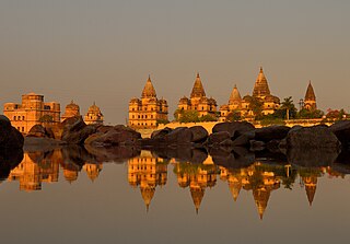
Orchha is a town, near the city of Niwari in the Niwari district of Madhya Pradesh state, India. The town was established by a Bundela rajput ruler Rudra Pratap Singh some time after 1501, as the seat of an eponymous former princely state of covering parts of central & north India, in the Bundelkhand region. Orchha lies on the Betwa River, 80 km from Tikamgarh & 15 km from Jhansi in Uttar Pradesh.
Chhatarpur is a city and a municipality in Chhatarpur district in the state of Madhya Pradesh, India. It is the administrative headquarters of Chhatarpur District.
Datia, also known as Daityavakra is the district headquarter of the Datia District in north central Madhya Pradesh, a state of Central India. It is an ancient town, mentioned in the Mahabharata ruled by King Dantavakra. The city is 78 km from Gwalior, 325 km south of New Delhi and 344 km north of Bhopal. About 18 km from Datia is Sonagiri, a sacred Jain hill. Datia is also about 28 km from Jhansi and 52 km from Orchha. The nearest airport is at Gwalior. It was formerly the seat of the eponymous princely state in the British Raj. Datia is situated near Gwalior and on the border with Uttar Pradesh.
Tikamgarh is a town and a tehsil in Tikamgarh district in the Indian state of Madhya Pradesh. The city serves as a district headquarters. The earlier name of Tikamgarh was Tehri consisting of three hamlets, forming a rough triangle. In Tikamgarh town there is locality still known as 'Purani Tehri'. Until Indian independence in 1947, Tikamgarh, formerly called Tehri, was part of the kingdom of Orchha, which was founded in the 16th century by the Bundeli chief Rudra Pratap Singh, who became the first King of Orchha. In 1783 the capital of the state was moved to Tehri, about 40 miles (64 km) south of Orchha, which was home to the fort of Tikamgarh, and the town eventually took the name of the fort. The district is famous for the old fort of Kundar known as Garh Kundar, which was built by Khangars and remained the capital of Khangar rulers from 1180 to 1347.
Datia District is one of important district in Gwalior Division in the Indian state of Madhya Pradesh. The town of Datia is its district headquarters.
Sagar Division is an administrative geographical unit of the Madhya Pradesh state of India. The city of Sagar is the division's administrative headquarters. As of 2023, the division consists of the districts of Sagar, Chhatarpur, Damoh, Panna, Tikamgarh, and Niwari.
Satna is a city in the Indian state of Madhya Pradesh. It serves as the headquarters of Satna district. It is 7th largest city and 8th most populous city of the state. The city is 500 km east of the state capital Bhopal. The city is distributed over a land area of 111.9 square kilometres.
Lalitpur is one of the 75 districts in the northern Indian state of Uttar Pradesh. Lalitpur district is a part of Jhansi Division. Lalitpur is the main town and administrative headquarters. The district occupies an area of 5,039 km2.
Bijawar is a city the state of Madhya Pradesh, India. It is the administrative headquarters of Bijawar Taluk, and was formerly the capital of a princely state of British India of the same name. The people of Bijawar are demanding the district status from their state government. It is the 53rd proposed district of Madhya Pradesh
Khargapur is a town and a nagar panchayat in Tikamgarh district in the Indian state of Madhya Pradesh. Khargapur is an assembly constituency.
Orchha State was a kingdom situated in the Bundelkhand region and later a princely state in British India. The state was ruled by Bundela clan of Rajputs. It was located within what is now the state of Madhya Pradesh.
Tikamgarh Assembly constituency is one of the 230 Vidhan Sabha constituencies of Madhya Pradesh state in central India. This constituency came into existence in 1951, as one of the 48 Vidhan Sabha constituencies of the erstwhile Vindhya Pradesh state.
Prithvipur Assembly constituency is one of the 230 Vidhan Sabha constituencies of Madhya Pradesh state in central India. Initially, it came into existence in 1951 as one of the 48 Vidhan Sabha constituencies of the erstwhile Vindhya Pradesh state, but it was abolished in 1956. This constituency again came into existence in 2008, following the delimitation of the legislative assembly constituencies. Prithvipur is small town of Bundelkhand. It's a city of politics.
Chhatarpur Assembly constituency is one of the 230 Vidhan Sabha constituencies of Madhya Pradesh state in central India. This constituency came into existence in 1951, as one of the 48 Vidhan Sabha constituencies of the erstwhile Vindhya Pradesh state.
Bijawar Assembly constituency is one of the 230 Vidhan Sabha constituencies of Madhya Pradesh state in central India. This constituency came into existence in 1951, as one of the 48 Vidhan Sabha constituencies of the erstwhile Vindhya Pradesh state.
Khaniadhana or Khaniyadhana was a princely state of British India ruled by the Judev dynasty of Bundela Rajputs. The capital of the State was Khaniadhana. It was part of the Bundelkhand Agency and later the Central India Agency.
Bijawar State was a princely state of colonial India, located in modern Chhatarpur district of Madhya Pradesh.
The Orchha Fort complex, which houses a large number of ancient monuments consisting of the fort, palaces, temple, and other edifices, is located in the Orchha town in the Indian state of Madhya Pradesh. The fort and other structures within it were built by the Bundela Rajputs starting from the early 16th century by King Rudra Pratap Singh of the Orchha State and others who followed him.
Niwari district is one of the 52 districts of the Madhya Pradesh state in India. Niwari is administrative headquarter of Niwari district.
This page is based on this Wikipedia article Text is available under the CC BY-SA 4.0 license; additional terms may apply. Images, videos and audio are available under their respective licenses.


