
Sagar is a city, municipal corporation and administrative headquarter in Sagar district of the state of Madhya Pradesh in central India. The city is situated on a spur of the Vindhya Range, 1,758 feet (536 m) above sea-level around 172 kilometres (107 mi) northeast of the state capital, Bhopal.
Bhind is a city in the Indian state of Madhya Pradesh. It is the headquarters of the Bhind district.
Bilaspur is a town and a municipal council in Bilaspur district in the Indian state of Himachal Pradesh.

Raisen District is a district of Madhya Pradesh state of India. The town of Raisen is the district headquarters. The district is part of Bhopal Division. Sanchi University of Buddhist-Indic Studies is the first international university located at Sanchi Town.

Chhatarpur District is a district of Madhya Pradesh state of central India. The town of Chhatarpur is the district headquarters.

Satna is a city in the Indian state of Madhya Pradesh. It serves as the headquarters of Satna district. It is 7th largest city and 8th most populous city of the state. The city is 500 km east of the state capital Bhopal. The city is distributed over a land area of 111.9 square kilometres.

Sagar district is a district of Madhya Pradesh state in central India. The town of Sagar serves as its administrative center.

Damoh District is a district of Madhya Pradesh state in central India. The town of Damoh is the district headquarters. The district is part of the Sagar Division.
Begumganj is a town and a municipality in Raisen district in the state of Madhya Pradesh, India. and is located on the Bhopal - Sagar National Highway 120 km away from Bhopal. It is one of the five divisions of the Raisen district.
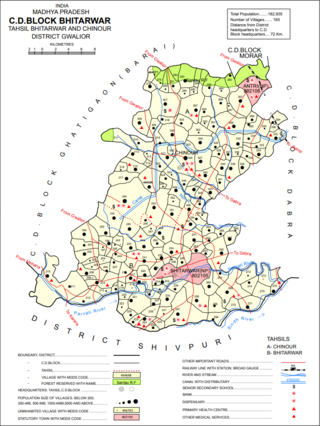
Bhitarwar is a city and a municipality in Gwalior district in the state of Madhya Pradesh, India. The town is surrounded by a river called Parbati.
Makronia is a municipality in Sagar district in the Indian state of Madhya Pradesh. Its part of Sagar Urban Agglomeration.
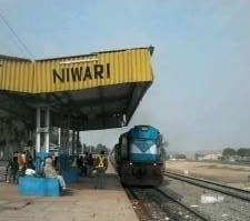
Niwari is a town and a nagar panchayat in Niwari district in the Indian state of Madhya Pradesh. It is the administrative headquarters of Niwari district.
Patharia is a town and a nagar panchayat in Damoh district in the Indian state of Madhya Pradesh. During World War II, the town served as the training camp for what would become Wingate's Chindits.
Hatta is the biggest Tehsil in Damoh district in the state of Madhya Pradesh, India. It is also headquarters of Hatta Tehsil.

Narsinghgarh is a town and a municipality, near Rajgarh city in Rajgarh district in the Indian state of Madhya Pradesh.

Deori, Sagar, is a historical city situated on the banks of the Sukhchain River, along the Narsinghpur-Sagar city road. Deori Kalan is a 150-year-old municipality in the Sagar district of Madhya Pradesh, India.

Rehli is one of the 230 Vidhan Sabha constituencies of Madhya Pradesh state in central India. This constituency came into existence in 1951, as one of the Vidhan Sabha constituencies of Madhya Pradesh state.

Banda(बंडा) is city and a Nagar panchayat in Sagar district of Madhya pradesh in India. Banda also a tehsil headquarter in Sagar.
Gaurjhamar is a town in Sagar district, Madhya Pradesh, India. It is located on NH 44. It is near the city of Deori.
Tada टड़ा is a village located in Sagar District of Madhya Pradesh. Sunar River originates from here. 470235 is pin Code of Tada Village. Some famous Jain temple is located there.


