History
Panna was a Bundela Rajput State. It was a Gond settlement until the 13th or 17th century (cite reference), when the Gondi were defeated by the Chandelas they migrated to other parts of Madhya Pradesh. Until that date, there were many rulers of the area. The famous mandir of Padmavatipuri Dham, adorned with divine lustre, is located in Panna town at the centre of Vindhyachal in Madhya Pradesh. The itinerant sage Mahamati Prannath and his disciples reached Panna with a divine message of awakening one's soul. Seeing a desert island, he decided to unfurl the flag of Jagani there. He helped the king Chhatrasal and adorned him with the title of Maharaja. He remained there for eleven years, and took samadhi inside the dome. The place, therefore, is known as the seat of salvation [Muktipitha] or Padmavatipuri Dham.
Panna was the capital of Chhatar Sal, the Bundela Rajput leader who led a revolt against the Mughal Empire. Upon his death in 1732, his kingdom was divided among his sons, with one-third of the kingdom going to his ally, the Maratha Peshwa Baji Rao I.
The Kingdom of Panna went to Harde Sah, the eldest son of Chhatar Sal Of Bundela Rajput Clan. In the early 19th century, Panna became a princely state of British India, and gained control states of the states of Nagod and Sohawal. Raja Nirpat Singh assisted the British in the Revolt of 1857, and the British rewarded him with the title maharaja. Maharaja Mahendra Yadvendra Singh acceded to the Government of India on 1 January 1950, and the kingdom became Panna District of the new Indian state of Vindhya Pradesh. Vindhya Pradesh was merged into Madhya Pradesh on 1 November 1956.
Tourism
Panna has a tiger reserve which is called Panna National Park. The sightings of tigers in Panna have fallen over recent years, and official tiger population figures were disputed by naturalists. There were plans to relocate two tigresses to Panna in 2009, [1] [2] which happened, but the last male tiger meanwhile disappeared. [3] A male tiger was relocated there. One of the relocated tigresses gave birth to three cubs in 2010. [4] The reserve is home to a wide variety of other animals, [5] many of which can be seen at closer quarters than in other reserves, because Panna has fewer visitors. There are jungle lodges and hotels near the reserve, it can also be reached from Khajuraho. Raneh fall, Pandav fall, brahspati kund and lakhanpur rain fall are also sites tourists visit during monsoon. Panna is also famous for its temples. Temples include Shree jugal Kishore ji, pran nath ji, Jagannath swami ji, ram Mandir and Govind dev ji temple.
Panoramic view of waterfall on Panna Bypass.
Diamond mining
A large group of diamond deposits extends North-East on a branch of the Vindhya Range for 240 kilometres (150 mi) or so, and is known as the Panna group. [6] They do not cover an area of more than 20 acres (81,000 m2). Great pits, 25 feet (7.6 m) in diameter and, perhaps, 30 feet (9.1 m) in depth, are dug for the sake of reaching the diamond conglomerate, which, in many cases, was only a very thin layer. [7] According to Valentine Ball, who edited the 1676 'Travels in India' of Jean-Baptiste Tavernier, Tieffenthaler was the first European to visit the mines in 1765 and claimed that the Panna diamonds could not compare in hardness and fire with other locations in India. No really large diamonds have come from this area. The most productive mines were in the 1860s and were found in Sakaria, around 32 kilometres (20 mi) from Panna. Four classifications were given to the Panna diamonds: first, Motichul, clear and brilliant; 2nd, Manik, with a faint orange tint; 3rd, Panna, verging in tint towards green; 4th, Bunsput, sepia coloured. [7] Mines is situated in the interior of Panna district. Diamond mines in Panna are managed under the Diamond Mining Project of National Mineral Development Corporation (NMDC Ltd), a Public Sector Undertaking (PSU) owned by the Government of India. In other mines the land is leased to prospective miners every year by the government agency. The diamonds unearthed are all collected by the district magistrate of Panna and are auctioned in the month of January. Auctions are open to the public and require a Rs. 5000 deposit. Upwards of 100 diamonds of different carat and shade are offered for auction.
Ajaigarh or Ajaygarh is a town and a nagar panchayat in the Panna District of Madhya Pradesh state in central India.

Bundelkhand is a geographical and cultural region and a proposed state and also a mountain range in central & North India. The hilly region is now divided between the states of Uttar Pradesh and Madhya Pradesh, with the larger portion lying in the latter state.

Chhatarpur is a city and a municipality in Chhatarpur district in the state of Madhya Pradesh, India. It is the administrative headquarters of Chhatarpur District.

Sagar is a city, municipal corporation and administrative headquarter in Sagar district of the state of Madhya Pradesh in central India. The city is situated on a spur of the Vindhya Range, 1,758 feet (536 m) above sea-level around 172 kilometres (107 mi) northeast of the state capital, Bhopal.

Datia, also known as Daityavakra is the district headquarter of the Datia District in north central Madhya Pradesh, a state of Central India. It is an ancient town, mentioned in the Mahabharata ruled by King Dantavakra. The city is 78 km from Gwalior, 325 km south of New Delhi and 344 km north of Bhopal. About 18 km from Datia is Sonagiri, a sacred Jain hill. Datia is also about 28 km from Jhansi and 52 km from Orchha. The nearest airport is at Gwalior. It was formerly the seat of the eponymous princely state in the British Raj. Datia is situated near Gwalior and on the border with Uttar Pradesh.

Tikamgarh is a town and a tehsil in Tikamgarh district in the Indian state of Madhya Pradesh. The city serves as a district headquarters. The earlier name of Tikamgarh was Tehri consisting of three hamlets, forming a rough triangle. In Tikamgarh town there is locality still known as 'Purani Tehri'. Until Indian independence in 1947, Tikamgarh, formerly called Tehri, was part of the kingdom of Orchha, which was founded in the 16th century by the Bundeli chief Rudra Pratap Singh, who became the first King of Orchha. In 1783 the capital of the state was moved to Tehri, about 40 miles (64 km) south of Orchha, which was home to the fort of Tikamgarh, and the town eventually took the name of the fort. The district is famous for the old fort of Kundar known as Garh Kundar, which was built by Khangars and remained the capital of Khangar rulers from 1180 to 1347.

Chhatarpur District is a district of Madhya Pradesh state of central India. The town of Chhatarpur is the district headquarters.

Satna is a city in the Indian state of Madhya Pradesh. It serves as the headquarters of Satna district. It is 7th largest city and 8th most populous city of the state. The city is 500 km east of the state capital Bhopal. The city is distributed over a land area of 111.9 square kilometres.
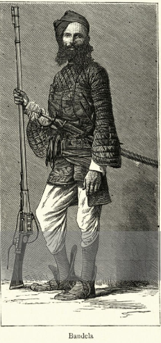
The Bundela is a Rajput clan. Over several generations, the cadet lineages of Bundela Rajputs founded several states in area what came to be known as Bundelkhand anciently known as Chedi Kingdom from the 16th century.
Bijawar is a city the state of Madhya Pradesh, India. It is the administrative headquarters of Bijawar Taluk, and was formerly the capital of a princely state of British India of the same name. The people of Bijawar are demanding the district status from their state government. It is the 53rd proposed district of Madhya Pradesh
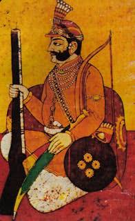
Chhatrasal Bundela was the Raja of Panna from 1675 to 1731. He is well known for his resistance against the Mughal Empire.

Chhatarpur Assembly constituency is one of the 230 Vidhan Sabha constituencies of Madhya Pradesh state in central India. This constituency came into existence in 1951, as one of the 48 Vidhan Sabha constituencies of the erstwhile Vindhya Pradesh state.

Bijawar Assembly constituency is one of the 230 Vidhan Sabha constituencies of Madhya Pradesh state in central India. This constituency came into existence in 1951, as one of the 48 Vidhan Sabha constituencies of the erstwhile Vindhya Pradesh state.

Chandla Assembly constituency is one of the 230 Vidhan Sabha constituencies of Madhya Pradesh state in central India. This constituency came into existence in 1951 as one of the 48 Vidhan Sabha constituencies of the erstwhile Vindhya Pradesh state, but it was abolished in 1956. It came into existence again in 1976. This constituency is reserved for the candidates belonging to the Scheduled castes since 2008, following delimitation of the legislative assembly constituencies.

Khaniadhana or Khaniyadhana was a princely state of British India ruled by the Judev dynasty of Bundela Rajputs. The capital of the State was Khaniadhana. It was part of the Bundelkhand Agency and later the Central India Agency.

Chhatarpur was one of the princely states of India during the period of the British Raj. The state was founded in 1785 and its capital was located in Chhatarpur, Madhya Pradesh.

Panna State was a kingdom and later princely state of colonial India, located in modern Panna district of Madhya Pradesh.

Jigni State was a princely state of the Bundelkhand Agency of the British Raj. It was a small Sanad state of about 82.87 km2 with a population of 4,297 inhabitants in 1901. The state was surrounded by the Hamirpur and Jhansi districts of the United Provinces.
Colonel HH Maharaja Sir Yadvendra Singh Judeo Bahadur, K.C.S.I., K.C.I.E. was Born in Bundela Rajput Family Of Panna. He was the 13th Maharaja of Panna State from years 1902 - 1947 and official Maharaja of Panna from 1947 till his death in 1963. He was awarded Kaiser-i-Hind Medal in 1916 and made Knight Commander of the Order of the Indian Empire (KCIE) in the 1922 New Year Honours.
Maheba, is a village and a tehsil in Chhatarpur district in the state of Madhya Pradesh, India. It is located 3.5km from National Highway 39.
This page is based on this
Wikipedia article Text is available under the
CC BY-SA 4.0 license; additional terms may apply.
Images, videos and audio are available under their respective licenses.


