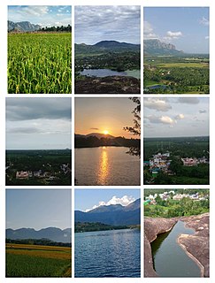
Puttur is a city in Dakshina Kannada district, in Karnataka state of India. It is the second largest and the fastest growing city in Dakshina Kannada district of Karnataka. The Puttur Shree Mahalingeshwara Temple is located here.
Kokrajhar is a city in the Bodoland Territorial Region, an autonomous territory in Assam, one of the North Eastern States of India.

Azhagiapandiapuram is a second grade town panchayat in Kanniyakumari district in the state of Tamil Nadu, India. It is located at the centre of Pazhayar valley. It is one of the four town panchayat's in Thovalai taluk.
Bissau is a town and a municipality in Jhunjhunu district in the state of Rajasthan, India.
Dhariawad is a census town in Pratapgarh district (Rajasthan) in the state of Rajasthan, India. It is the administrative headquarters for Dhariawad Tehsil.
Edaikazhinadu is a panchayat town in Chengalpattu district in the state of Tamil Nadu, India. Edaikazhinadu was situated near villages Vennangupattu, Kadappakkam. Alamparai fort, a 17th century historical fort, is located in this region.

FRI and College Area is a census town of Forest Research Institute, in Dehradun district of Uttarakhand, India.
Hesla is a village in Bagodar CD Block in Bagodar-Saria subdivision of Giridih district in the Indian state of Jharkhand.
Iriveri is a census town in Kannur district in the Indian state of Kerala.
Karunguzhi is a town in Chengalpattu district in the Indian state of Tamil Nadu
Kiriburu is a census town in Jharkhand. The town is mainly known for having big Iron-ore Mines KIOM & MIOM both governed by Steel Authority of India Limited (SAIL). The road connecting the township to the mines is divided by the border of Odisha and Jharkhand. It is also a famous hill station situated in the core of Saranda forest. Saranda forest is land of seven hundred hills. The name of the forest Saranda is due to the large number of elephants found in this forest. The forest has some good water falls and hill views.
Kudligi is a panchayat town in Vijayanagara district in the India state of Karnataka. Kudligi is famous for its climatic location and fruits & vegetables. Once upon a time Kudligi was called as "The Land of rich spices" for foreign tourists who came to Hampi. Now it is called as "The Tamarind Nadu". Here Kotthala Anjaneya festival is popular during Ugadhi Festival. Kudligi was ruled by few kings from Jarmali and Madakari kingdom. Gandhiji Chithabasma was carried by Bindu Madava and his friend Guddada Karnam Venkoba Rao.
Kumbhkot is a census town in Kota district in the Indian state of Rajasthan.
Maharajganj is a town and municipal board in Maharajganj district in the Indian state of Uttar Pradesh.
Meghahatuburu is a census town in West Singhbhum district of the Indian state of Jharkhand. The town was largely built by the Steel Authority of India Limited as it is the Raw Material Division of SAIL.

Narnaul is a city, a Municipal Council, and location of headquarters of the Mahendragarh district in the Indian state of Haryana. It is located in the National Capital Region of India.

Vikarabad is a town and mandal in Vikarabad district of the Indian state of Telangana. It is located in Vikarabad mandal of Vikarabad revenue division.

Dehradun Cantonment is a cantonment town in Dehradun district in the state of Uttarakhand, India. It was established in 1913.
Shikaripur or Shikaripura is a town in Shimoga district in the Indian state of Karnataka. It is the headquarters of Shikaripur taluk.

Redhakhol is a town and a notified area committee in Sambalpur district in the Indian state of Odisha.It has the following banks: Canara Bank, DCB Bank, State Bank of India, Union Bank, Utkal Gramin Bank, and Central Bank. Redhakhol town, which is the Sub-Divisional headquarter of Rairakhol Sub-division and surrounded by a green belt of reserve forest, is unique for its natural beauty, cleanness, and pollution-free zone. The town is 67 K.M. from Sambalpur and 260 K.M. from Bhubaneswar. Sambalpur-Cuttack the old National Highway 42 now renamed as National Highway 55 is passing through this town. After the opening of the Kiakata bridge on Rairakhol-Kiakata State Highway, this town has become a junction point, as it opens easy & straight communication to Phulbani & Berhampur. The historical Deogarh town is situated to its North & is connected by 88 K.M. length of Blacktopping road leading to Ranchi Vijayawada Highway.


