
Madhya Pradesh is a state in central India. Its capital is Bhopal, and the largest city is Indore, with Jabalpur, Ujjain, Gwalior, Satna being the other major cities. Madhya Pradesh is the second largest Indian state by area and the fifth largest state by population with over 72 million residents. It borders the states of Uttar Pradesh to the northeast, Chhattisgarh to the southeast, Maharashtra to the south, Gujarat to the west, and Rajasthan to the northwest.

The Satpura Range is a range of hills in central India. The range rises in eastern Gujarat running east through the border of Maharashtra and Madhya Pradesh and ends in Chhattisgarh. The range parallels the Vindhya Range to the north, and these two east-west ranges divide Indian Subcontinent into the Indo-Gangetic plain of northern India and the Deccan Plateau of the south. The Narmada River originates from north-eastern end of Satpura in Amarkantak, and runs in the depression between the Satpura and Vindhya ranges, draining the northern slope of the Satpura range, running west towards the Arabian Sea. The Tapti River originates in the eastern-central part of Satpura, crossing the range in the center and running west at the range's southern slopes before meeting the Arabian Sea at Surat, draining the central and southern slopes of the range. Multai, the place of Tapi river origin is located about 465 kilometer far, south-westerly to Amarkantak, separated across by the hill range. The Godavari River and its tributaries drain the Deccan plateau, which lies south of the range, and the Mahanadi River drains the easternmost portion of the range. The Godavari and Mahanadi rivers flow into the Bay of Bengal. At its eastern end, the Satpura range meets the hills of the Chotanagpur Plateau. The Satpura Range is a horst mountain and is flanked by Narmada Graben in the north and much smaller but parallel Tapi Graben in the south.

Chhatarpur is a city and a municipality in Chhatarpur district in the state of Madhya Pradesh, India. It is the administrative headquarters of Chhatarpur District.

Rio Tinto Group is an Anglo-Australian multinational and the world's second-largest metals and mining corporation, behind BHP, producing iron ore, copper, diamonds, gold and uranium. The company was founded in 1873, when a multinational consortium of investors purchased a mine complex on the Rio Tinto, in Huelva, Spain, from the Spanish government. Since then, the company has grown through a long series of mergers and acquisitions to place itself among the world leaders in the production of many commodities, including aluminium, iron ore, copper, uranium and diamonds. Although primarily focused on extraction of minerals, Rio Tinto also has significant operations in refining, particularly for refining bauxite and iron ore. Rio Tinto has joint head offices in London and Melbourne.

Kanha Tiger Reserve, also known as Kanha–Kisli National Park, is one of the tiger reserves of India and the largest national park of the state of Madhya Pradesh. The present-day Kanha area is divided into two protected areas, Hallon and Banjar, of 250 and 300 km2, respectively. Kanha National Park was created on 1 June 1955 and was designated a tiger reserve in 1973. Today, it encompasses an area of 940 km2 (360 sq mi) in the two districts Mandla and Balaghat.
The Indian government has established 18 biosphere reserves to protect larger areas of natural habitat than a typical national park or animal sanctuary, and that often include one or more national parks or reserves, along with buffer zones that are open to some economic uses. Protection is granted not only to the flora and fauna of the protected region, but also to the human communities who inhabit these regions, and their ways of life.

Rajgarh district is a district of Madhya Pradesh in central India. The city of Rajgarh is the administrative headquarters of the district. The old name of Rajgarh was Jhanjhanipur, and was ruled by the Bhils. Rajgarh in Madhya Pradesh is one of the aspirational districts selected by Government of India. The district has an area of 6,154 km² and the population is 1,545,814. The district lies on the northern edge of the Malwa plateau, and the Parbati River forms the eastern boundary of the district, while the Kali Sindh River forms the western boundary. The district has seven tehsils, Rajgarh, Khilchipur, Jirapur, Biaora, Narsinghgarh, Sarangpur and Pachore. The district is bounded by Rajasthan state to the north, and by the districts of Guna to the northeast, Bhopal to the east, Sehore to the southeast, and Shajapur to the south and west. It is part of Bhopal Division. There are 1728 villages in Rajgarh.

Coal India Limited (CIL) is an Indian government-owned coal mining and refining corporation. It is under the ownership of Ministry of Coal, Government of India headquartered in Kolkata, West Bengal, India. It is the largest coal-producing company in the world and a Maharatna public sector undertaking. It is also the fifth largest employer in India with nearly 272,000 employees.

The Narmada Valley dry deciduous forests are a tropical dry forest ecoregion of central India. The ecoregion lies mostly in Madhya Pradesh state, but extends into portions of Chhattisgarh, Maharashtra, Karnataka and Uttar Pradesh states.

Buxwaha is a Tehsil and a nagar panchayat in Chhatarpur district in the state of Madhya Pradesh, India.

Delhi Ridge, sometimes simply called The Ridge, is a ridge in the Northern Aravalli leopard wildlife corridor in the National Capital Territory of Delhi in India. It is a northern extension of the ancient Aravalli Range, some 1.5 billion years old. The ridge consists of quartzite rocks and extends from the southeast at Tughlaqabad, near the Bhatti mines, branching out in places and tapering off in the north near Wazirabad on the west bank of the river Yamuna, covering about 35 kilometres.

Resolution Copper (RCM) is a joint venture owned by Rio Tinto and BHP formed to develop and operate an underground copper mine near Superior, Arizona, U.S. The project targets a deep-seated porphyry copper deposit located under the now inactive Magma Mine. Rio Tinto has reported an inferred resource of 1.624 billion tonnes containing 1.47 percent copper and 0.037 percent molybdenum at depths exceeding 1,300 metres (0.81 mi). The proposed mine is one of the largest copper resources in North America. Following the passage of the 2015 National Defense Authorization Act, many Native American and conservation groups fear the copper mine will destroy the area around Oak Flat immediately above the deposit.

Singrauli district is one of the districts in the India state of Madhya Pradesh.
Resources are classified as either biotic or abiotic on the basis of their origin. The Indian landmass contains a multitude of both types of resources and its economy, especially in rural areas, is heavily dependent on their consumption or export. Due to overconsumption, they are rapidly being depleted.
This article is about the conservation in Bhopal, the capital of Madhya Pradesh state of India.

Conservation in India can be traced to the time of Ashoka, tracing to the Ashoka Pillar Edicts as one of the earliest conservation efforts in the world. Conservation generally refers to the act of carefully and efficiently using natural resources. Conservation efforts begun in India before 5 AD, as efforts are made to have a forest administration. The Ministry of Environment, Forest and Climate Change is the ministry responsible for implementation of environmental and forestry program in India, which include the management of national parks, conservation of flora and fauna of India, and pollution controls.
Mining scam in India refers to a series of alleged widespread scams in various ore-rich states of India, which has generated controversy. Such issues span encroachment of forest areas, underpayment of government royalties, conflict with tribals regarding land-rights. The spill-over of the effects of legal mining into issues such as Naxalism and the distortion of the Indian political system by mixed politics and mining interests, has gained international attention.
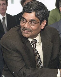
Subramaniam Vishwanathan Iyer,, is currently the Vice President and Chief Operating Officer of the Multilateral Investment Guarantee Agency, the former Managing Director of Rio Tinto India, and had previously served as Director of Energy and Sustainable Development at the World Bank Group.

Diamond mining in India extends back into antiquity. From ancient times, India was the source of nearly all the world's known diamonds, and until the discovery of diamonds in South Africa in 1896, India was the only place where diamonds were mined. India has not been a major diamond-producing country since the 1900s, but diamond mining continues. In 2013, India mined 37,515 carats of diamonds, from one industrial-scale mine and many artisanal mines; this was less than one-tenth of one percent of the world production of 132.9 million carats.

