Places of interest
Rani Durgawati sanctuary: is located near to Singrampur where you can find all wild animals.
Singorgarh fort : is near to Singrampur is another place of historical importance. It was built by Raja Vain Bason. Gond Rajas stayed in it for a long time. It was with Gond Raja Dalpat Shah and his Rani Durgawati at the end of the 15th century. There is also a lake here, which is full of lotus flowers. This is an ideal picnic spot.
Najaraa: 6 km from Singrampur towards Kalumar on W.B.M. road there is road leading to the spot called "Nazara". This place has been developed as a platform on the top of the mountain giving a breath taking overview of the Rani Durgawati Abhyaran. The sight of the thick forest can be enjoyed from here. The caves of the wild animals on the hills can also be seen. Wild animals are also spotted roaming around in the forest.
Giri Darshan: Situated on the High way from Damoh to Jabalpur 5 km from Jabera and 7 km from Sigrampur toward Damoh on a green hill in the jungle a beautiful double storeyed rest house cum watch tower was built by the Forest Dept. It is a notable piece of Architecture. From the main road a narrow path along of the bank of a tank reaches this rest house. The reservation to stay in the rest house can be made at DFO office at Damoh. The sight of the roads of the small hills and views of the sunrise and the sunset await the visitors. This view can be seen from the terrace of the rest house. The wild animals also can be seen at night.
Nidhan Kund: Almost 1/2 km from the Bhainsaghat Rest House towards the Bhainsa village (5 km from Singrampur), a road goes to this waterfall. One kilometer from the main road a stream between the high black rocks flows down from more than 100 ft (30 m) height. This is called Nidan Kund. During the months of July and August there is much water in the stream so the sight of this fall from the front is impressive. It becomes a picnic spot in September and October as water in the stream is reduced. There are step-like formations on the black rocks against the flow of the stream which create a spectacle when the water flow is high.
Sad-Bhawna Sikhar: It is the highest point of the Vindhya Range. On Bhainsa - Kalumar road there cuts a forest road which is almost 6 km long. A view of the area around it can be seen from here. This peak is 2467 ft (752 m) above sea level. The twinkling light of Jabalpur city can be seen from here at clear nights. It is not very easy to climb this peak so it is convenient to use a jeep or any other 4 wheeler. It is 10 km from Singrampur.

Jabalpur is a city situated on the banks of Narmada River in the state of Madhya Pradesh, India. According to the 2011 census, it is the third-largest urban agglomeration in Madhya Pradesh and the country's 38th-largest urban agglomeration. Jabalpur is an important administrative, industrial and business center of Madhya Pradesh. It is the judicial capital of Madhya Pradesh as The Madhya Pradesh High Court along with other important administrative headquarters of India and Madhya Pradesh are located in Jabalpur. It is generally accepted that the game of Snooker originated in Jabalpur. Jabalpur is the administrative headquarters of Jabalpur district and the Jabalpur division. It also is a major education centre in India. The city is known for the marble rocks on the river Narmada at Bhedaghat.

Pachmarhi is a hill station in the Narmadapuram district of Madhya Pradesh state of central India. It has been the location of a cantonment since British Raj.
The Satpura Range is a range of hills in central India. The range rises in eastern Gujarat running east through the border of Maharashtra and Madhya Pradesh and ends in Chhattisgarh. The range parallels the Vindhya Range to the north, and these two east-west ranges divide Indian Subcontinent into the Indo-Gangetic plain of northern India and the Deccan Plateau of the south. The Narmada River originates from north-eastern end of Satpura in Amarkantak, and runs in the depression between the Satpura and Vindhya ranges, draining the northern slope of the Satpura range, running west towards the Arabian Sea. The Tapti River originates in the eastern-central part of Satpura, crossing the range in the center and running west at the range's southern slopes before meeting the Arabian Sea at Surat, draining the central and southern slopes of the range. Multai, the place of Tapi river origin is located about 465 kilometer far, south-westerly to Amarkantak, separated across by the hill range. The Godavari River and its tributaries drain the Deccan plateau, which lies south of the range, and the Mahanadi River drains the easternmost portion of the range. The Godavari and Mahanadi rivers flow into the Bay of Bengal. At its eastern end, the Satpura range meets the hills of the Chotanagpur Plateau. The Satpura Range is a horst mountain and is flanked by Narmada Graben in the north and much smaller but parallel Tapi Graben in the south.
Narsinghpur is a city in Madhya Pradesh in central India. It is a district under Jabalpur division. Narsinghpur has a large temple dedicated to Lord Narasimha. As of 2001, Narsinghpur is the most literate district of the state.
Harda is a town and a municipality in Harda district in the Indian state of Madhya Pradesh. Harda is the administrative headquarters of Harda.
Chhindwara is a city in India and a Municipal Corporation in Chhindwara district in the Indian state of Madhya Pradesh. The city is the administrative headquarters of Chhindwara District. Chhindwara is reachable by rail or road from adjacent cities Betul, Jabalpur and Nagpur. The nearest airport is in Nagpur (130 km); however there is a small airport located in the city which is not serviceable for passenger planes.
Mandla is a city with municipality in Mandla district in the Indian state of Madhya Pradesh. It is the administrative headquarters of Mandla District. The city is situated in a loop of the Narmada River, which surrounds it on three sides, and for 15 miles between Mandla and Ramnagar, Madhya Pradesh the river flows in a deep bed unbroken by rocks. The Narmada is worshiped here, and many ghats have been constructed on the banks of the river. It was a capital of the Gondwana Kingdom who built a palace and a fort, which in the absence of proper care have gone to ruins.
Seoni District is a district of Madhya Pradesh state in central India. The town of Seoni is the district headquarters.
Seoni is a city and a municipality in Seoni district in the Indian state of Madhya Pradesh. This tribal household dominated district was formed in the year 1956. Rudyard Kipling used the forests in the vicinity of Seoni, or as was spelled during British colonial rule, Seeonee, as the setting for the Mowgli stories in The Jungle Book and The Second Jungle Book (1894–1895), although the area is not an actual rainforest. Seoni is a city where tributary of the river Godavari, the Wainganga, originates. Seoni is reachable by road, major adjacent cities are Nagpur and Jabalpur. The National Highway 44 north–south corridor crosses from Seoni. The nearest airport is Nagpur (130 km); a small airport (air-strip) is available at Seoni near Sukhtara village for landing charter airplanes/helicopters. The Wainganga is a river in India originating in the Mahadeo Hills in Mundara near the village Gopalganj in Seoni, Madhya Pradesh. It is a key tributary of the Godavari. The river flows south in a winding course through the states of Madhya Pradesh and Maharashtra, roughly 579 km (360 mi). After joining the Wardha River, the united stream, which is known as the Pranahita River, empties into the Godavari River at Kaleshwaram, Telangana.

Damoh District is a district of Madhya Pradesh state in central India. The town of Damoh is the district headquarters. The district is part of the Sagar Division.
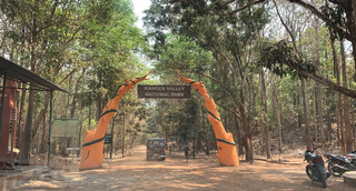
Kanger Ghati National Park was declared a national park in 1982 by the Government of India. Near Jagdalpur in the Bastar region of Chhattisgarh, it is one of India's densest national parks, and is known for its biodiversity, landscape, waterfalls, and subterranean geomorphologic limestone caves, and as the home of the Bastar hill myna, the state bird of Chhattisgarh.

Navegaon National Park is a National park located in the Arjuni Morgaon subdivision of Gondia district in state of Maharashtra, India. The Dr Salim Ali Bird Sanctuary, Navegaon is home to almost 60% of the bird species found in entire Maharashtra. Every winter, flocks of migratory birds visit the lake. The national park has diverse type of vegetation ranging from dry mixed forest to moist forest. The forest type is 5 A/C3. Southern tropical dry deciduous forest.
Kareli is a city and a Municipality in the Indian state of Madhya Pradesh. Kareli is financial capital of the district Narsinghpur. Kareli is considered as best production town for Jaggery in India. Jaggery produced in Kareli is a single kadhai Jaggery which is highly demanded in many parts of India. It is well connected by transportation. Near Kareli, an ancient fair called Barman Mela is organised every year in the month of January on the bank of the river Narmada. There are many historic and religious places in Kareli like Chougan Quila,Deepeshwar Temple Barman, Deepeshwar temple is dedicated to lord Shiva. It is also taposthali of lord Bramha. India's longest highway NH-44 passes through Kareli and also connected to almost every part of the country by rail network. Before the construction of the Bina-Katni branch of the Indian Midland Railway, the metaled road from Saugor crossing the Nerbudda at Barmhan brought the bulk of the produce of the Sagar District to Kareli station. A mail cart ran from Kareli to Sagar, a distance of 122 km (76 mi). The trade of Kareli has now considerably declined, but it is still the exporting station for the southern parts of the Rehli tahsil of Sagar and the north of Narsinghpur. A cotton-ginning factory, the property of Raja Gokul Das, was opened in 1904. This is the nearest rail station and market for towns of Sagar district. Kareli is also educational hub for nearby area Schools like Govt. C.M.Rise School, Carmel School, Mahatma Gandhi College and many coaching institutes are situated. Agriculture based business are still doing well in the area like Kareli Sugar Mills, Dal Mills, there are many Tuar dal Mills in the city like Chacha Dal Mill, Oil plants like Shubham industries, Flour Mills like Malviya Mills, Jaggery Factories.
Nainpur is a town and Municipal Council in the Mandla district, of the Indian state of Madhya Pradesh.
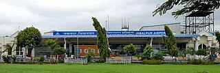
Jabalpur Airport, also known as Dumna Airport, is a domestic airport serving the city of Jabalpur, Madhya Pradesh, India. It is located at Dumna, 25 km (16 mi) east of the city. It is the third busiest airport in Madhya Pradesh after Devi Ahilya Bai Holkar International Airport in Indore and Raja Bhoj Airport in Bhopal in terms of both passenger and aircraft movements. The Airports Authority of India (AAI) is upgrading the airport to provide better services to the air travellers of the region. The upgrades are expected to be completed by the end of 2023, and the new terminal building is to be commissioned by March 2023.
Nauradehi Wildlife Sanctuary, covering about 1,197 km2 (462 sq mi), is the largest wildlife sanctuary of Madhya Pradesh state in India. This wildlife sanctuary is a part of 5500 km2 of forested landscape. It is located in the centre of the state covering parts of Sagar, Damoh, Narsinghpur, and Raisen Districts. It is about 90 km from Jabalpur and about 56 km from Sagar.
Singorgarh Fort, is a hill-fort located in Damoh district in the Madhya Pradesh state of Central India. It is about 45 km from Jabalpur city, on the way to Damoh town. It is presently under the Archeological Survey of India.
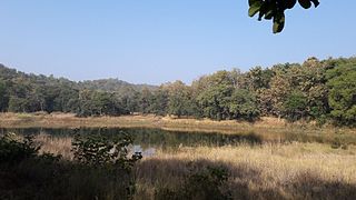
Veerangana Durgawati Wildlife Sanctuary is a wildlife sanctuary in Damoh district of Madhya Pradesh, India. Named after Rani Durgavati, a queen of the Gondi people, and covering an area of only 24 sq km, the sanctuary was notified by the Government of Madhya Pradesh in 1996.
The Garha Kingdom, also called Garha Mandla or Garha Katanga, was an early-modern-era kingdom in India. It was the first large kingdom to be founded by the Gond tribe and dominated much of Central India at its peak.
