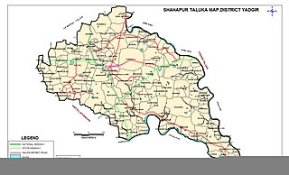
Shahapur is a city and taluka headquarter located in the Yadgir district of Indian state of Karnataka. Shahapur is 597 km north of Bangalore and well connected by road to Gulbarga (70 km), Hyderabad (240km), Bidar (160 km), Raichur (90 km) and Yadgir (32 km).
Charkhari is a city in Mahoba district in the state of Uttar Pradesh, India. This is the Kashmir of Bundelkhand. It was the capital of the Charkhari concession. There are lakes named Vijay Sagar, Malkhan Sagar, Vanshi Sagar, Jai Sagar, Ratan Sagar and Kothi Tal. There are 108 temples of Krishna giving the nature and beauty of Vraj to Charkhari city. In which Gopal Bihari temple of Sudamapuri, Guman Bihari of Ryanpur, temple of Mangalgarh, Bakht Bihari, temple of Banke Bihari and cave of Madavya Rishi are there. It is also the headquarters of Charkhari Tehsil and the name of Legislative Assembly seat is also Charkhari. Legislative Assembly constituency.

Kanakapura is a town in the Ramanagara district of Karnataka on the banks of the Arkavathi river and the administrative center of the taluk of the same name. Previously belonged to Bangalore Rural District. It was formerly the largest constituency in the country. The taluk is very widespread (1,553 km2 [600 sq mi]). It is located among the lush green forests of the state of Karnataka. The town is a tourism hotspot and an often visited tourist favorite in the entire state of Karnataka, as it has something for everyone ranging from avid trekkers to history buffs and wildlife enthusiasts.The forest area in this taluk is very wide and about half of the Bannerghatta National Park is located in our Kanakapura area.Kodihalli wildlife range and harohalli wildlife range its division.The Kaveri Wildlife Sanctuary consists of two main zones namely the Sangam Wildlife range, the Mugur Wildlife range
Bhimarayanagudi is a town administered by a notified area committee in Shahpur Taluk of Yadgir district, in the state of Karnataka, India. It is approximately 4 km by road north of Shahpur town. It is also referred to as B.Gudi and Bhimarayanagudi camp.
Jaisinagar is a town and a nagar panchayat in Sagar district in the Indian state of Madhya Pradesh.
Karrapur is a census town in Sagar district in the Indian state of Madhya Pradesh.
Katangi is a City and a Municipal Council in Balaghat District in the Indian state of Madhya Pradesh.
Panagar is a town with municipality in Jabalpur district in the Indian state of Madhya Pradesh.
Payal is a city in Ludhiana district in the Punjab, India.
Raikot is a city and municipal council in Ludhiana district in Indian state of Punjab. Raikot is one of the tehsils in Ludhiana district of Punjab. there are total 76 villages in this tehsil. A list of villages in Raikot tehsil is given on this page.
Rajakhedi is a census town in Sagar district in the Indian state of Madhya Pradesh.
Sagar Cantonment is a cantonment town in Sagar district in the Indian state of Madhya Pradesh.
Sahapur is a census town in Panchla CD Block of Howrah Sadar subdivision in Howrah district in the Indian state of West Bengal.
Shahgarh is a town and a tahsil in Sagar district in the Indian state of Madhya Pradesh. Its connected with National Highway No. 86 Route, National Highway 539 and MP SH 37.
Titilagarh is a town and Municipality in Balangir district in the Indian state of Odisha.
Vijayapuri (North) is a census town in Nalgonda district in the Indian state of Telangana. It Consists of two colonies, Hill Colony and Pylon Colony. These colonies are basically constructed to accommodate the workers of Nagarjuna Sagar Dam construction who later settled there with several government jobs. There are government and private educational institutes from KG to Degree. For professional degrees like engineering and medicine, students travel to nearby cities like Hyderabad (150 km) and Nalgonda (100 km).

Shahpur is a town and a notified area in Bhojpur district in the Indian state of Bihar.
Shahpur is a town and a nagar panchayat in Muzaffarnagar district in the Indian state of Uttar Pradesh. As of 2001, it had a population of 17,186.
Shahpur is a town and a nagar panchayat in Burhanpur district in the Indian state of Madhya Pradesh.
Shahpur is a census town in Betul district in the Indian state of Madhya Pradesh.
