
Lalitpur is a city and a municipal board in Lalitpur District, India in the Indian state of Uttar Pradesh. It is also district headquarters of Lalitpur district. The city is part of Bundelkhand region.

Orchha is a town, near the city of Niwari in the Niwari district of Madhya Pradesh state, India. The town was established by a Bundela rajput ruler Rudra Pratap Singh some time after 1501, as the seat of an eponymous former princely state of covering parts of central & north India, in the Bundelkhand region. Orchha lies on the Betwa River, 80 km from Tikamgarh and 15 km from Jhansi in Uttar Pradesh.

Datia, also known as Daityavakra is the district headquarter of the Datia District in north central Madhya Pradesh, a state of Central India. It is an ancient town, mentioned in the Mahabharata ruled by King Dantavakra. The city is 71 km from Gwalior, 325 km south of New Delhi and 344 km north of Bhopal. About 18 km from Datia is Sonagiri, a sacred Jaina hill. Datia is also about 52 km from Orchha. The nearest airport is at Gwalior. It was formerly the seat of the eponymous princely state in the British Raj. Datia is situated near Gwalior and on the border with Uttar Pradesh.

Tikamgarh is a town and a tehsil in Tikamgarh district in the Indian state of Madhya Pradesh. The city serves as a district headquarters. The earlier name of Tikamgarh was Tehri consisting of three hamlets, forming a rough triangle. In Tikamgarh town there is locality still known as 'Purani Tehri'. Until Indian independence in 1947, Tikamgarh, formerly called Tehri, was part of the kingdom of Orchha, which was founded in the 16th century by the Bundeli chief Rudra Pratap Singh, who became the first King of Orchha. In 1783 the capital of the state was moved to Tehri, about 40 miles (64 km) south of Orchha, which was home to the fort of Tikamgarh, and the town eventually took the name of the fort. The district is famous for the old fort of Kundar known as Garh Kundar, which was built by Khangars and remained the capital of Khangar rulers from 1180 to 1347.

Datia District is one of important district in Gwalior Division in the Indian state of Madhya Pradesh. The town of Datia is its district headquarters.

Bhind district is a district in the Chambal division of the Indian state of Madhya Pradesh.

Sagar Division is an administrative geographical unit of the Madhya Pradesh state of India. The city of Sagar is the division's administrative headquarters. As of 2023, the division consists of the districts of Sagar, Chhatarpur, Damoh, Panna, Tikamgarh, and Niwari.

Satna is a city in the Indian state of Madhya Pradesh. It serves as the headquarters of Satna district. It is 7th largest city and 8th most populous city of the state. The city is 500 km east of the state capital Bhopal. The city is distributed over a land area of 111.9 square kilometres.

Barwani district is one of the districts of Madhya Pradesh state of India. The administrative headquarters of the district is at Barwani.

Tikamgarh district is one of the 55 districts of Madhya Pradesh state in central India. Tikamgarh town is the district headquarters. The district is part of Sagar Division.

Ujjain district is a district of Madhya Pradesh state in central India. The historic city of Ujjain is the district headquarters. The district has an area of 6,091 km2, and a population of 19,86,864, a 16.12% increase from its 2001 population of 17,10,982.

Lalitpur is one of the 75 districts in the northern Indian state of Uttar Pradesh. Lalitpur district is a part of Jhansi Division. Lalitpur is the main town and administrative headquarters. The district occupies an area of 5,039 km2.
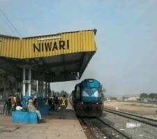
Niwari is a town and a nagar panchayat in Niwari district in the Indian state of Madhya Pradesh. It is the administrative headquarters of Niwari district.
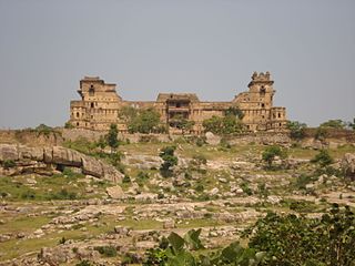
Garh Kundar is a small village in the city of Niwari district of Madhya Pradesh. It has been named so after the splendid fort, or "Garh", of Kundar located here. From 925 to 1507 AD, Garh Kundar fort witnessed many battles and bloodshed. Yashovarma Chandel built the fort after conquering south western Bundelkhand. In the battle between Prithviraj Chauhan and the Chandels in 1182 AD fort commander. Shayaji Parmar lost and the fort came under Prithviraj Chauhan. Then Rajput King Prithviraj Chauhan appointed Khub Singh khangar as the ruler of this fort who founded the Khangar Dynasty afterwards.

Orchha State was a kingdom situated in the Bundelkhand region and later a princely state in British India. The state was ruled by Bundela clan of Rajputs. It was located within what is now the state of Madhya Pradesh.

Prithvipur Assembly constituency is one of the 230 Vidhan Sabha constituencies of Madhya Pradesh state in central India. Initially, it came into existence in 1951 as one of the 48 Vidhan Sabha constituencies of the erstwhile Vindhya Pradesh state, but it was abolished in 1956. This constituency again came into existence in 2008, following the delimitation of the legislative assembly constituencies. Prithvipur is small town of Bundelkhand. It's a city of politics.

Niwari Assembly constituency is one of the 230 Vidhan Sabha constituencies of Madhya Pradesh state in central India. This constituency came into existence in 1951, as one of the 48 Vidhan Sabha constituencies of the erstwhile Vindhya Pradesh state.

Khargapur Assembly constituency is one of the 230 Vidhan Sabha constituencies of Madhya Pradesh state in central India. This constituency came into existence in 1967, following the delimitation of the Legislative Assembly constituencies and it was reserved for the candidates belonging to the scheduled castes from 1967 to 2008.
Bhamoura Khas is a village and a gram panchayat in Niwari Tehsil in the Tikamgarh district in the Indian state of Madhya Pradesh. Bhamoura Khas belongs to the Sagar Division. It is located 78 kilometers north from the district headquarters Tikamgarh and 317 kilometers from the state capital Bhopal. Bhamoura Khas is on the border of the Tikamgarh District and Jhansi District. Bhamoura Khas is surrounded by Prithvipur Tehsil on the South, Mauranipur Tehsil on the East, and Chirgaon Tehsil on the North.
Teharka is a village in Niwari Tehsil in the Tikamgarh district of the Indian state of Madhya Pradesh. Teharka belongs to the Sagar Division. Teharka is the only village with two gram panchayats in Niwari Tehsil. It is located 78 km north of the district headquarters, Tikamgarh, and 320 km from the state capital, Bhopal. Teharka has borders with Prithvipur Tehsil in the south, Mauranipur Tehsil in the east, and Chirgaon Tehsil in the north.


