
Madhya Pradesh is a state in central India. Its capital is Bhopal, and the largest city is Indore, with Jabalpur, Gwalior, Ujjain, Satna, Sagar, Rewa, Khandwa, being the other major cities. Madhya Pradesh is the second largest Indian state by area and the fifth largest state by population with over 75 million residents. It borders the states of Uttar Pradesh to the northeast, Chhattisgarh to the southeast, Maharashtra to the south, Gujarat to the west, and Rajasthan to the northwest.

Madhya Bharat, also known as Malwa Union, was an Indian state in west-central India, created on 28 May 1948 from twenty-five princely states which until 1947 had been part of the Central India Agency, with Jiwajirao Scindia as its Rajpramukh.

Vindhya Pradesh was a former state of India. It occupied an area of 23,603 sq. miles. It was created in 1948 as Union of Baghelkhand and Bundelkhand States, shortly after Indian independence, from the territories of the princely states in the eastern portion of the former Central India Agency. It was named as Vindhya Pradesh on 25 January 1950 after the Vindhya Range, which runs through the centre of the province. The capital of the state was Rewa. It lay between Uttar Pradesh to the north and Madhya Pradesh to the south, and the enclave of Datia, which lay a short distance to the west, was surrounded by the state of Madhya Bharat.

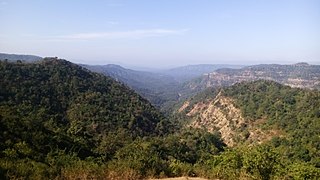
Hoshangabad, officially Narmadapuram, is a city and municipality in the Indian state of Madhya Pradesh. It is known as The Ageless City. It serves as the headquarters of both Hoshangabad district and Narmadapuram division. It is located in central India, on the south bank of the Narmada River. Hoshangabad is 76.7 km from the state capital Bhopal. Nearest airport Bhopal.

Harda is a town and a municipality in Harda district in the Indian state of Madhya Pradesh. Harda is the administrative headquarters of Harda District.

Itarsi is a city and municipality in Madhya Pradesh, India in Hoshangabad District. Itarsi is a key hub for agricultural goods and is the biggest railway junction in Madhya Pradesh. Rail services from all 4 major metropolitan cities of India namely Mumbai to Calcutta and Delhi to Chennai pass through Itarsi.Itarsi has large number of agro-based industries and warehouses. Itarsi got its name by "eeta(eent)", and "rassi",. Bricks and ropes had been made earlier in itarsi. It has Ordnance Factory. The Bori Wildlife Sanctuary and Tawa Dam are nearby. Nearest airport Bhopal.
Betul district is a district of Madhya Pradesh state in central India. The city of Betul serves as its administrative headquarters. The district is a part of Narmadapuram Division.

Harda District is a district of Madhya Pradesh state of central India. The town of Harda is the district headquarters. The district is part of Narmadapuram Division. Harda district was organized in 1998.Harda is also known as 'Hridaynagari'. This small district is known for peace and wellbeing.
Bhopal Division is an administrative geographical unit of Madhya Pradesh state of central India. Bhopal is the administrative headquarters of the division. The division consists of districts of Bhopal, Raisen, Rajgarh, Sehore, and Vidisha.
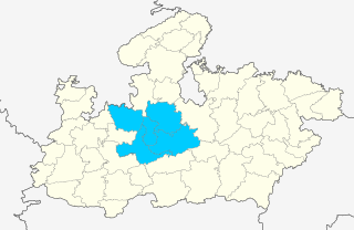
Guna district is one of the 52 districts of Madhya Pradesh in central India. Its administrative headquarters is Guna. The district has a population of 1,241,519. It has an area of 6390 km², and is bounded on the northeast by Shivpuri District, on the east by Ashoknagar District, on the southeast by Vidisha District, on the southwest by Rajgarh District, on the west and northwest by Jhalawar and Baran districts of Rajasthan state. The Sindh River flows northward along the eastern edge of the district, forming part of the boundary with Ashoknagar District, and the Parbati River flows northwestward through the southern portion of the district, forming part of the boundary with Baran District before flowing into Rajasthan.

Hoshangabad district, officially Narmadapuram district, is one of the districts of Madhya Pradesh state of India, and Hoshangabad town is the district headquarters.
The Indore District is a district of Madhya Pradesh state in central India. The name of the district comes from the city of Indore, which is its administrative capital. This district forms part of the Indore Division.

Vidisha District (विदिशा) is in Madhya Pradesh state, in central India. The city of Vidisha is the administrative headquarters of the district.

Shivpuri District is a district of Madhya Pradesh state of India. The town of Shivpuri is the district headquarters. National Highway 3 (NH-3) runs through the district.

Bhopal District is a district of Madhya Pradesh state in central India. The city of Bhopal serves as its administrative headquarters. The district is part of Bhopal Division.

Sehore District is a district of Madhya Pradesh state in central India. The town of Sehore is the district headquarters. The district is part of Bhopal Division.

Dholpur District is a district of Rajasthan state in Northern India. The town of Dholpur is the district headquarters. Dholpur District is a part of Bharatpur Divisional Commissionerate.

Tangutur is a town in Prakasam district of the Indian state of Andhra Pradesh. It is a mandal headquarters in Ongole revenue division. Nearby towns are Singarayakonda, Kandukur, Prakasam district, Kondapi and the nearest city will be Ongole.

Shahdol Division is an administrative division of the Indian state of Madhya Pradesh.
Madhya Pradesh Cricket Association Ground or Neemkheda Stadium is a multi-purpose stadium in Jabalpur, Madhya Pradesh, India. The ground is mainly used for organizing matches of football, cricket and other sports. The ground has floodlights so that the stadium can host day-night matches. It is made considering all norms of BCCI so that Ranji Trophy matches can be played. The stadium was established in 2012 when the stadium hosted a match of Dr Shafquat Mohammed Khan Under-18 Inter Divisional Tournament 2011/12 between Jabalpur Under-18s v Narmadapuram Under-18s.
