
Puthunagaram is a town and gram panchayat in the Palakkad district, state of Kerala, India. It is about 10 km south of Palakkad and 8 Km from Kollengode. Palakkad-Pollachi railway line passes through this town.
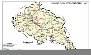
Shahapur is a city and taluka headquarter located in the Yadgir district of Indian state of Karnataka. Shahapur is 597 km north of Bangalore and well connected by road to Gulbarga (70 km), Hyderabad (240 km), Bidar (160 km), Raichur (90 km) and Yadgir (32 km).
Phillaur is a town and a municipal council as well as a tehsil in Jalandhar district in the Indian state of Punjab. The city is situated 20 km from Ludhiana, 45 km from Jalandhar and 140 km from Amritsar. It is situated on the border of the Doaba and Puadh regions. Thr city was Founded by a Hindu Jat, Chaudhary Phul Rai Sanghera, during the 12-13th century as Phulnagar, but later came to be known as Phillaur.
Bhimarayanagudi is a town administered by a notified area committee in Shahpur Taluk of Yadgir district, in the state of Karnataka, India. It is approximately 4 km by road north of Shahpur town. It is also referred to as B.Gudi and Bhimarayanagudi camp.

Birwadi is a census town in Raigad district in the state of Maharashtra, India.
Ezhudesam is a town panchayat in Kanniyakumari district in the state of Tamil Nadu, India.
Herohalli is a census town in Bangalore district in the Indian state of Karnataka.
Lingasugur is a municipal town in Raichur district in the Indian state of Karnataka. There are many Temples, hills and forts (Quila). The festivals of Muharram and Maha Shivaratri are important here. Mudgal in Lingasugur taluk has a very ancient fort. It has often been mentioned in the autobiography of Philip Meadows Taylor. Lingasugur, then known as Chavani was the site of a major British cantonment in the region.
Naravarikuppam is a town in Thiruvallur district in the Indian state of Tamil Nadu.
Raikot is a city and municipal council in Ludhiana district in Indian state of Punjab. Raikot is one of the tehsils in Ludhiana district of Punjab. there are total 76 villages in this tehsil. A list of villages in Raikot tehsil is given on this page.
Sahapur is a census town in Panchla CD Block of Howrah Sadar subdivision in Howrah district in the Indian state of West Bengal.
Thevaram is a town in Theni district in the Indian state of Tamil Nadu. Thevaram is located in Tamil Nadu near the border of Kerala at the Eastern side foot-hill of the Western Ghats. It is connected with State Highway SH100.
Vengathur is a census town in Thiruvallur district in the Indian state of Tamil Nadu.

Shahpur is a town and a notified area in Bhojpur district in the Indian state of Bihar.
Shahpur is a town and a nagar panchayat in Muzaffarnagar district in the Indian state of Uttar Pradesh. As of 2001, it had a population of 17,186.
Shahpur is a town and a Nagar panchayat in Burhanpur district in the Indian state of Madhya Pradesh.
Shahpur is a town and a nagar parishad in Sagar district in the Indian state of Madhya Pradesh.
Kerur is a town in Bagalkot district in Karnataka, which located on NH 218. It has an average elevation of 617 meters (2024 feet). It's the birthplace of Jagadish Shettar, a former Chief Minister of Karnataka. Kerur is a Town Panchayat city in the district of Bagalkot, Karnataka. The Kerur city is divided into 16 wards for which elections are held every five years. The Kerur Town Panchayat has a population of 19,731 of which 9,929 are males while 9,802 are females as per report released by Census India 2011.
Saliwada Camp a very small village in the Chopna region in the Indian state of Madhya Pradesh.

Shahpur is a village in Lalganj block of Rae Bareli district, Uttar Pradesh, India. It is located 8 km from Lalganj, the block and tehsil headquarters. As of 2011, it has a population of 689 people, in 126 households. It has 1 primary school and no healthcare facilities, and it hosts both a permanent market and a weekly haat. It belongs to the nyaya panchayat of Behta Kalan.

