
Madhya Pradesh is a state in central India. Its capital is Bhopal, and the largest city is Indore, with Gwalior, Jabalpur, Ujjain, Dewas, Sagar, and Rewa being the other major cities. Madhya Pradesh is the second largest Indian state by area and the fifth largest state by population with over 72 million residents. It borders the states of Uttar Pradesh to the northeast, Chhattisgarh to the east, Maharashtra to the south, Gujarat to the west, and Rajasthan to the northwest.

The West Central Railway, one of the 19 zones of the Indian Railways, came into existence on 1 April 2003. It is headquartered at Jabalpur. It was created by taking away two divisions namely Bhopal division and Jabalpur division from central railways and one division namely Kota division from western railway. The WCR zone provides rail route coverage to the west central region of India. Most of its route is in the states of Madhya Pradesh and Rajasthan with a very little portion in the state of Uttar Pradesh.

Pachmarhi is a hill station in the Hoshangabad district of Madhya Pradesh state of central India. It has been the location of a cantonment since the British Raj. The municipality is located in a valley of the Satpura Range and is widely known as Satpura ki Rani.

Hoshangabad, officially Narmadapuram, is a city in the Indian state of Madhya Pradesh. It serves as the headquarters of both Hoshangabad district and Narmadapuram division. It is located in central India, on the south bank of the Narmada River. Hoshangabad is 76.7 km (47.7 mi) from the capital of Madhya Pradesh and the nearest airport Bhopal.
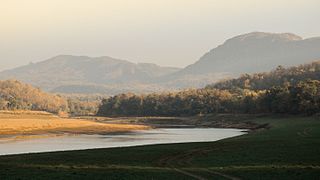
Satpura Tiger Reserve (STR) also known as Satpura National Park is located in the Narmadapuram district of Madhya Pradesh in India. Its name is derived from the Satpura range. It covers an area of 524 km2 (202 sq mi). Satpura National Park, along with the adjoining Bori and Pachmarhi wildlife sanctuaries, provides 2,200 km2 (850 sq mi) of unique central Indian highland ecosystem. It was set up in 1981.

Itarsi is a city and municipality in Narmadapuram in Madhya Pradesh, India. Itarsi is a key hub for agricultural goods and is the biggest railway junction in Madhya Pradesh. Rail services from all 4 major metropolitan cities of India namely Mumbai to Kolkata and Delhi to Chennai pass through Itarsi. Itarsi has large number of agro-based industries and warehouses. Itarsi got its name by "eeta(eent)", and "rassi",. Bricks and ropes had been made earlier in Itarsi. It has an Ordnance Factory. The Bori Wildlife Sanctuary and Tawa Dam are nearby.

Hoshangabad district, officially Narmadapuram district, is one of the districts of Madhya Pradesh state of India, and Hoshangabad city is the district headquarters.

Kareli is a city and a Municipality in the Indian state of Madhya Pradesh. Kareli is financial capital of the district Narsinghpur. Kareli is considered as best production town for Jaggery in India. Jaggery produced in Kareli is a single kadhai Jaggery which is highly demanded in many parts of India. It is well connected by transportation. Near Kareli, an ancient fair called Barman Mela is organised every year in the month of January on the bank of the river Narmada. There are many historic and religious places in Kareli like Chougan Quila,Deepeshwar Temple Barman, Deepeshwar temple is dedicated to lord Shiva. It is also taposthali of lord Bramha. India's longest highway NH-44 passes through Kareli and also connected to almost every part of the country by rail network. Before the construction of the Bina-Katni branch of the Indian Midland Railway, the metaled road from Saugor crossing the Nerbudda at Barmhan brought the bulk of the produce of the Sagar District to Kareli station. A mail cart ran from Kareli to Sagar, a distance of 122 km (76 mi). The trade of Kareli has now considerably declined, but it is still the exporting station for the southern parts of the Rehli tahsil of Sagar and the north of Narsinghpur. A cotton-ginning factory, the property of Raja Gokul Das, was opened in 1904. This is the nearest rail station and market for towns of Sagar district. Kareli is also educational hub for nearby area Schools like Govt. C.M.Rise School, Carmel School, Mahatma Gandhi College and many coaching institutes are situated. Agriculture based business are still doing well in the area like Kareli Sugar Mills, Dal Mills, there are many Tuar dal Mills in the city like Chacha Dal Mill, Oil plants like Shubham industries, Flour Mills like Malviya Mills, Jaggery Factories.
Sohagpur is a town and a nagar panchayat in Narmadapuram district in the Indian state of Madhya Pradesh. It is one of the subdivisions and development blocks in Narmadapuram district. Sohagpur is also one of the legislative constituencies of Madhya Pradesh. Sohagpur is famour for its Betel culture, and an enormous quantity of betel is exported from here.
Banapura is a small town in the Hoshangabad District of Madhya Pradesh, India. Banapura is a twin city of Seoni Malwa.

Saugor is a railway station in Sagar city in Madhya Pradesh. It is operated by the West Central Railway, with its headquarters at Jabalpur. Saugor is a 'A' Category railway station of West Central Railway zone of Indian Railways. Saugor is a major railway station of Bina–Katni line. The station consists of two platforms. Passenger, Express and Superfast trains halt here.

The 12853 / 12854 Amarkantak Express is a daily Superfast Express train which runs between the Bhopal Junction railway station in Bhopal, the capital city of Madhya Pradesh and Durg, a city in Chhattisgarh state in central India. This train replaced the 8225/8226 Bhopal–Bilaspur Mahanadi Express along with the 8291/8292 Bhopal–Raipur Express and the 1235/1236 Bhopal–Jabalpur Express.

The 12061 / 12062 Rani Kamalapati–Jabalpur Jan Shatabdi Express is a type of Jan Shatabdi Express train service offered by West Central Railway.
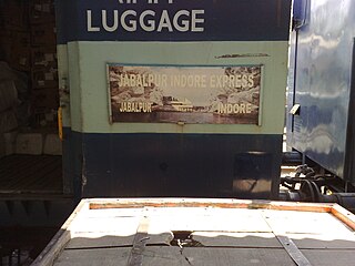
The 22191 / 22192 Jabalpur–Indore Overnight Express is a daily Superfast train of the Indian Railways, which runs between Jabalpur Junction railway station of Jabalpur, an important city & military cantonment hub of India, and Indore Junction, the main railway station in Indore, the commercial hub and largest city of the Central India in the state of Madhya Pradesh.

Chhindwara Junction railway station serves Chhindwara in Chhindwara district in the Indian state of Madhya Pradesh.
Seth Ruda Ladha Chawra, Rai Saheb (1884–1948) was a noted railway contractor and Kutchi industrialist, who established himself at Bagra, India.
Pipariya railway station is a railway station serving Pipariya town, in Narmadapuram district of Madhya Pradesh State of India. Pipariya is A category station of West Central Railway Zone of Indian Railways. It is under Jabalpur railway division of West Central Railway Zone of Indian Railways. It is located on Itarsi - Jabalpur main line of the Indian Railways.
Tawa Nagar is a town in Madhya Pradesh state of India. It is located in near Itarsi Junction in Narmadapuram district. Itarsi is a key hub for agricultural goods and is the biggest, oldest & the busiest railway junctions in Madhya Pradesh. Rail services from all 4 major metropolitan cities of India namely Mumbai to Calcutta and Delhi to Chennai pass through Itarsi. It has Ordnance Factory Itarsi of the Ordnance Factories Board which manufactures products for the Indian Armed Forces. The Bori Wildlife Sanctuary and Tawa Dam are nearby.

Lodhikheda railway station is a railway station in Lodhikheda, in the Indian state of Madhya Pradesh.It situated at the junction of Nagpur–Jabalpur and Nagpur–Chhindwara main lines.
Bankhedi is a town and a Nagar Parishad in Narmadapuram District of Madhya Pradesh. It is also a tehsil headquarter.


