Pachmarhi is a hill station in the Hoshangabad district of Madhya Pradesh state of central India. It has been the location of a cantonment since the British Raj. The municipality is located in a valley of the Satpura Range and is widely known as Satpura ki Rani.

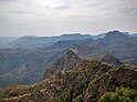
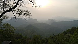
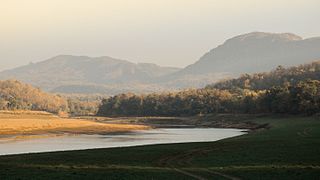
The Satpura Range is a range of hills in central India. The range rises in eastern Gujarat running east through the border of Maharashtra and Madhya Pradesh and ends in Chhattisgarh. The range parallels the Vindhya Range to the north, and these two east–west ranges divide Indian Subcontinent into the Indo-Gangetic plain of northern India and the Deccan Plateau of the south. The Narmada River originates from north-eastern end of Satpura in Amarkantak, and runs in the depression between the Satpura and Vindhya ranges, draining the northern slope of the Satpura range, running west towards the Arabian Sea. The Tapti River originates in the eastern-central part of Satpura, crossing the range in the center and running west at the range's southern slopes before meeting the Arabian Sea at Surat, draining the central and southern slopes of the range. Multai, the place of Tapi river origin is located about 465 kilometer far, south-westerly to Amarkantak, separated across by the hill range. The Godavari River and its tributaries drain the Deccan plateau, which lies south of the range, and the Mahanadi River drains the easternmost portion of the range. The Godavari and Mahanadi rivers flow into the Bay of Bengal. At its eastern end, the Satpura range meets the hills of the Chotanagpur Plateau. The Satpura Range is a horst mountain and is flanked by Narmada Graben in the north and much smaller but parallel Tapi Graben in the south.

Hoshangabad, officially Narmadapuram, is a city in the Indian state of Madhya Pradesh. It serves as the headquarters of both Hoshangabad district and Narmadapuram division. It is located in central India, on the south bank of the Narmada River. Hoshangabad is 76.7 km (47.7 mi) from the capital of Madhya Pradesh and the nearest airport Bhopal.

The Tawa River is a tributary of the Narmada River of Central India.
Harda is a city and a municipality in Harda district in the Indian state of Madhya Pradesh. Harda is the administrative headquarters of Harda.
Satpura Tiger Reserve (STR) also known as Satpura National Park is located in the Narmadapuram district of Madhya Pradesh in India. Its name is derived from the Satpura range. It covers an area of 524 km2 (202 sq mi). Satpura National Park, along with the adjoining Bori and Pachmarhi wildlife sanctuaries, provides 2,200 km2 (850 sq mi) of unique central Indian highland ecosystem. It was set up in 1981.

Betul district is a district of Madhya Pradesh state in central India. The city of Betul serves as its administrative headquarters. The district is a part of Narmadapuram Division.

Harda District is a district of Madhya Pradesh state of central India. The town of Harda is the district headquarters. The district is part of Narmadapuram Division. Harda district was organized in 1998. Harda is also known as 'Hridaynagari'.

Chhindwara district is one of the major districts of Madhya Pradesh state of India, and Chhindwara town is the district headquarters. Chhindwara was the largest district in Madhya Pradesh with an area of 10,293 square km before the bifurcation of Pandhurna district. The district is part of Jabalpur division.

Khandwa district, formerly known as the East Nimar district, is a district of the Madhya Pradesh state in central India. The city of Khandwa is the administrative headquarters of the district. Other notable towns in the district include Mundi, Harsud, Pandhana and Omkareshwar.

Sehore District is a district of Madhya Pradesh state in central India. The town of Sehore is the district headquarters. The district is part of Bhopal Division.

The Central Provinces was a province of British India. It comprised British conquests from the Mughals and Marathas in central India, and covered parts of present-day Madhya Pradesh, Chhattisgarh and Maharashtra states. Nagpur was the primary winter capital while Pachmarhi served as the regular summer retreat. It became the Central Provinces and Berar in 1903.
Pipariya or Pipariya Hathwas is a town and a municipality in Hoshangabad district Indian State of Madhya Pradesh. It is also a tehsil headquarters and a Assembly Constituency.

Ghoradhongri is a town and a Nagar Parishad in Betul District of Madhya Pradesh. Its also a Tehsil Headquarter and Assembly constituency.
Banapura is a small town in the Hoshangabad District of Madhya Pradesh, India. Banapura is a twin city of Seoni Malwa.

The Rajat Prapat is a waterfall in Narmadapuram district in the Indian state of Madhya Pradesh. It is the 30th highest waterfall in India.
Seth Ruda Ladha Chawra, Rai Saheb (1884–1948) was a noted railway contractor and Kutchi industrialist, who established himself at Bagra, India.
The Nerbudda Division, named after the Narmada River (Nerbudda), was a former administrative division of the Central Provinces of British India. It encompassed a good part of the Narmada River basin in the eastern part of present-day Madhya Pradesh state of India. The Nerbudda Division had an area of 47,609.2 km2 with a population of 1,785,008 in 1901.
Pipariya railway station is a railway station serving Pipariya town, in Narmadapuram district of Madhya Pradesh State of India. Pipariya is A category station of West Central Railway Zone of Indian Railways. It is under Jabalpur railway division of West Central Railway Zone of Indian Railways. It is located on Itarsi - Jabalpur main line of the Indian Railways.
Bankhedi is a town and a Nagar Parishad in Narmadapuram District of Madhya Pradesh. It is also a tehsil headquarter.