Orsang

Last updated
Orsang river.jpg

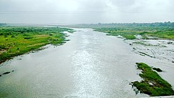
The Orsang River flows through the Chhota Udaipur district and Vadodara district in Gujarat, India. It joins with the Narmada River at the village of Chandod. [1] It is originates from the forest of Bhavra in Madhya Pradesh and enters in Gujarat near Chhota Udepur town.

The river is the primary provider of sand within Gujarat, which encourages a variety of sand mining activities, especially within the region between Bodeli and Chhota Udepur. [2]

Related Research Articles

<span class="mw-page-title-main">Narmada River</span> River of central India in a rift valley

The Narmada River, also called the Reva and previously also known as Narbada or anglicised as Nerbudda, is the 5th longest river and overall longest west-flowing river in India. It is also the largest flowing river in the state of Madhya Pradesh. This river flows through the states of Madhya Pradesh and Gujarat in India. It is also known as the "Life Line of Madhya Pradesh and Gujarat" due to its huge contribution to the two states in many ways. The Narmada River rises from the Amarkantak Plateau in Anuppur district Madhya Pradesh. It forms the traditional boundary between North India and South India and flows westwards over a length of 1,312 km (815.2 mi) before draining through the Gulf of Khambhat into the Arabian Sea, 30 km (18.6 mi) west of Bharuch city of Gujarat.

<span class="mw-page-title-main">Sardar Sarovar Dam</span> Dam in Gujarat, India

The Sardar Sarovar Dam is a concrete gravity dam built on the Narmada River in Navagam near the town of Kevadiya, Narmada District, in the state of Gujarat, India. The dam was constructed to provide water and electricity to four Indian states: Gujarat, Madhya Pradesh, Maharashtra, and Rajasthan.

<span class="mw-page-title-main">Narmada district</span> District of Gujarat in India

Narmada district is an administrative district in the state of Gujarat in India. The district headquarters are located at Rajpipla. The district is bounded by Vadodara and Chhota Udaipur districts in the north, by Nandurbar district of Maharashtra state in the east, by Surat and Tapi districts in the south and by Bharuch district in the west. The district occupies an area of 2,755 km² and has a population of 590,297. It was 10.44% urban as of 2011. As of 2011, it is the third least populous district of Gujarat, after Dang and Porbandar.

<span class="mw-page-title-main">Mahi River</span> River in India

The Mahi is a river in western India. It rises in Madhya Pradesh and, after flowing through the Vagad region of Rajasthan, enters Gujarat and flows into the Arabian Sea. It is one of the relatively few west-flowing rivers in India, alongside the endorheic Luni River, the Sabarmati River, the Tapi River and the Narmada River. Most peninsular rivers in India flow eastward into the Bay of Bengal or northward into the Ganges River.

<span class="mw-page-title-main">Rewa Kantha Agency</span>

Rewa Kantha was a political agency of British India, managing the relations of the British government's Bombay Presidency with a collection of princely states. It stretched for about 150 miles between the plain of Gujarat and the hills of Malwa, from the Tapti River to the Mahi River crossing the Rewa River, from which it takes its name.

<span class="mw-page-title-main">Bodeli</span> Town in Gujarat, India

Bodeli is a town and taluka in Chhota Udaipur district in the eastern part of the state of Gujarat, India.

Nandurbarpronunciation  is a city and a municipal council in Nandurbar district in the Indian state of Maharashtra. Nandurbar municipal corporation is the first municipal corporation. The District Nandurbar was formed from the district Dhule on July 1, 1998. Nandurbar is an administrative district in the northwest corner of of Maharashtra. On 1 July 1998 Dhule was bifurcated as two separate districts now known as Dhule and Nandurbar. The district headquarters is located at Nandurbar city. The district occupies an area of 5034 km2 and has a population of 1,311,709 of which 15.45% is urban. Nandurbar district is bounded to the south and south-east by Dhule district, to the west and north is the state of Gujarat, to the north and north-east is the state of Madhya Pradesh. The northern boundary of the district is defined by the great Narmada river. It came into limelight during February 2006 bird flu crisis which struck many of its poultry farms. Thousand of chickens from the farms had to be killed and buried in nearby grounds to stop the virus spreading.

<span class="mw-page-title-main">Kalpasar Project</span> Dam

The Kalpasar Project or the Gulf of Khambhat Development Project envisages building a 30 km dam across the Gulf of Khambat in India for establishing a huge fresh water coastal reservoir for irrigation, drinking and industrial purposes. The project with 30 km sea dam will have the capacity to store 10,000 million cubic meters fresh water, equating to 25% of Gujarat’s average annual rainwater flow, from the rivers like Narmada, Mahi, Dhadhar, Sabarmati, Limbdi-Bhagovo, and two other minor rivers. A 10 lane road link will also be set up over the dam, greatly reducing the distance between Saurashtra and South Gujarat. The project, which will create world's largest freshwater lake in marine environment, will cost INR90,000 crore or US$12.75 billion excluding the cost of tidal power plant. Project entails construction of the main "Kalpasar dam" across Gulf of Khambat and another Bhadbhut barrage on Narmada river, as well as a canal connecting the two.

The Ghanchi (Ghaanchi) are a Muslim community found in the states of Gujarat, Maharashtra and Rajasthan in India. A small number of Ghanchi are also found in the city of Karachi in Pakistan.

<span class="mw-page-title-main">Narmada Canal</span> River in Rajasthan, India

The Narmada Canal is a contour canal in Western India that brings water from the Sardar Sarovar Dam to the state of Gujarat and then into Rajasthan state. The main canal has a length of 532 kilometres (331 mi). It is the second longest canal in India and the largest canal by water carrying capacity. The main canal is connected with 42 branch canals providing irrigation to 2,129,000 hectares farmland. The canal is designed to transfer 9.5 million acre-feet water annually from the Narmada Basin to areas under other river basins in Gujarat and Rajasthan..

Shetrunji River is an eastward-flowing river in Bhavnagar, Gujarat, in western India.

<span class="mw-page-title-main">Chhota Udaipur district</span> District of Gujarat in India

Chhota Udaipur district is a district in the state of Gujarat in India. It was carved out of the Vadodara district on 26 January 2013 with its headquarters at Chhota Udaipur town and is the 28th district of Gujarat.

<span class="mw-page-title-main">Chhota Udaipur State</span> Princely state of India

The Chhota Udaipur State or 'Princely State of Chhota Udaipur', was a princely state with its capital in Chhota Udaipur during the era of British India. The last ruler of Chhota Udaipur State signed the accession to join the Indian Union in 1948. Chhota Udaipur shares a history with Devgadh Baria and Rajpipla as one of the three princely states of eastern Gujarat.

Chhota Udaipur is one of the 182 Legislative Assembly constituencies of Gujarat state in India. It is part of Chhota Udaipur district and is reserved for candidates belonging to the Scheduled Tribes.

Sankheda is one of the 182 Legislative Assembly constituencies of Gujarat state in India. It is part of Chhota Udaipur district and is reserved for candidates belonging to the Scheduled Tribes.

Nandod is one of the 182 Legislative Assembly constituencies of Gujarat state in India. It is part of Narmada district and is reserved for candidates belonging to the Scheduled Tribes. The seat came into existence due to the delimitation exercise in 2008 and it is a part of the Chhota Udaipur Lok Sabha constituency.

Sukhi Dam is an embankment dam on the Sukhi River near the village of Dungarvat in Chhota Udepur district of Gujarat, India. The primary purpose of the dam is the irrigation of a 31,532 ha area with nearly 350 km (220 mi) of canals. It was built between 1978 and 1987. The dam is an earth-fill type with a masonry spillway section.

Chhota Udaipur railway station is a small railway station in Chhota Udaipur district, Gujarat. Its code is CTD and it serves Chhota Udaipur town. The station lacks running water and sanitation and its two platforms are not well sheltered.

Chhota Molla Khali is a village and a gram panchayat within the jurisdiction of the Gosaba police station in the Gosaba CD block in the Canning subdivision of the South 24 Parganas district in the Indian state of West Bengal.

References

  1. "Orsang River - River Data - Data Bank - Narmada (Gujarat State)". Guj-nwrws.gujarat.gov.in. Retrieved 5 February 2019.
  2. "Sand mining leases around Orsang River suspended". The Times of India . Retrieved 5 February 2019.

Coordinates: 22°25′N74°11′E / 22.417°N 74.183°E / 22.417; 74.183