Jhabua district

Last updated

Jhabua district
Ploughing a field.jpg
Farmer in Jhabua district
MP Jhabua district map.svg
Location of Jhabua district in Madhya Pradesh
CountryFlag of India.svg  India
State Madhya Pradesh
Division Indore
Headquarters Jhabua
Government
   District collector Rajani Singh (IAS)
   Lok Sabha constituencies Ratlam
   Vidhan Sabha constituencies Jhabua (193)
Area
  Total3,782 km2 (1,460 sq mi)
Population
 (2011)
  Total1,025,048
  Density270/km2 (700/sq mi)
Demographics
   Literacy 44.45 per cent
  Sex ratio989
Time zone UTC+05:30 (IST)
Average annual precipitation800 mm
Website jhabua.nic.in

Jhabua is a district of Madhya Pradesh state in central India. The town of Jhabua is the administrative headquarters of the district.

Contents

Geography

Jhabua district lies in the western part of Madhya Pradesh. It is surrounded by Dahod and Chhota Udaipur districts of Gujarat, Banswara district of Rajasthan, and Alirajpur, Dhar and Ratlam districts of Madhya Pradesh. [1]

It has an area of 3,782 km2. The terrain is hilly and undulating. Average rainfall in the district is about 800 mm. The district is divided into five tehsils and six community development blocks. [1]

Jhabua district was divided into two parts in May 2008, namely Alirajpur and Jhabua. Alirajpur, Jobat, Udaigarh, Bhabra, Sondawa and Kathiwada are the 6 blocks of new district, Alirajpur. Jhabua district now consists of Jhabua, Meghnagar, Ranapur, Rama, Thandla and Petlawad blocks.

Bhil tribe girls in Jhabua district Bhil tribe girls in Jhabua.jpg
Bhil tribe girls in Jhabua district

Economy

The district is highly drought-prone and degraded waste lands form the matrix of Jhabua. The women make lovely ethnic items including bamboo products, dolls, bead-jewellery and other items that have for long decorated the living rooms all over the country. The men have for ages adorned "Teer-Kamthi", the bow and arrow, which has been their symbol of chivalry and self-defence.

In 2006 the Ministry of Panchayati Raj named Jhabua one of the country's 250 most backward districts (out of a total of 640). [2] It is one of the 24 districts in Madhya Pradesh currently receiving funds from the Backward Regions Grant Fund Programme (BRGF). [2]

Demographics

Historical population
YearPop.±% p.a.
190183,750    
1911116,878+3.39%
1921135,558+1.49%
1931158,464+1.57%
1941186,035+1.62%
1951207,418+1.09%
1961285,619+3.25%
1971374,686+2.75%
1981447,438+1.79%
1991646,924+3.76%
2001784,286+1.94%
20111,025,048+2.71%
source: [3]
Religions in Jhabua district (2011) [4]
ReligionPercent
Hinduism
93.74%
Christianity
3.75%
Islam
1.53%
Jainism
0.87%
Other or not stated
0.11%

According to the 2011 census Jhabua District has a population of 1,025,048, [5] roughly equal to the nation of Cyprus [6] or the US state of Montana. [7] This gives it a ranking of 440th in India (out of a total of 640). [5] The district has a population density of 285 inhabitants per square kilometre (740/sq mi). [5] Its population growth rate over the decade 2001–2011 was 30.58%. [5] Jhabua has a sex ratio of 989 females for every 1000 males, [5] and a literacy rate of 44.45%. 8.97% of the population lives in urban areas. Scheduled Castes and Tribes made up 1.70% and 87.00% of the population respectively. [5]

As per the 2001 census Jhabua district (considering the separation of Alirajpur) had a total population of 784,286, out of which 396,141 were males and 388,145 were females. 91 per cent of the population was rural. 85.60 per cent of the population was tribal and 3 per cent belonged to scheduled castes. [1] Before the separation of Alirajpur, Jhabua district had a sex ratio of 990 and density of population stood at 206 / km2. [8]

Jhabua is a predominantly Adivasi district, and suffers from high rates of illiteracy and poverty. Almost half of the population lives below the poverty line. The Bhil and Bhilala peoples inhabit the interior of the district. More than 85% of the population speak different Bhili dialects.

Languages

Languages of Jhabua district (2011) [9]

   Bhili (82.19%)
   Hindi (9.37%)
   Malvi (3.45%)
   Bhilali (2.40%)
  Others (2.59%)

At the time of the 2011 Census of India, 82.19% of the population in the district spoke Bhili, 9.37% Hindi, 3.45% Malvi and 2.40% Bhilali as their first language. [9]

Languages spoken include Rathwi Bareli, a Bhil language with approximately 64 000 speakers, written in the Devanagari script; [10] and Bhilali, with 1 150 000 speakers. [11]

Literacy

According to 2001 census, with a literacy rate 36.9 per cent Jhabua district had the lowest literacy rate amongst districts of Madhya Pradesh. [12] In 2011 this had increased only marginally to 43.3%.

Culture

A small village of 320 people in 1971, Deojhiri is 8 km north-east of Jhabua on the Ahmedabad-Indore State Highway No.22. It is at a distance of 1 km on the western side of the road, on the Sunar river. As the name of the village denotes there is an ancient temple and (Jhiri) or a perennial spring. The spring has been built up into a Kund. A festival is held on Baisakh Poornima, which falls mostly in the month of April according to the Gregorian calendar. Katthivada in Jhabua district is noted for its large mangoes.

Tourist Places

See also

Related Research Articles

<span class="mw-page-title-main">Nandurbar district</span> District in Maharashtra, India

Nandurbar district is an administrative district in the northwest corner of Maharashtra state in India. On 1 July 1998 Dhule was bifurcated as two separate districts now known as Dhule and Nandurbar. Nandurbar is a tribal-dominated district, The district headquarters are located at Nandurbar city. The district occupies an area of 5955 km2 and has a population of 1,648,295 of which 16.71% were urban.

<span class="mw-page-title-main">Bhil languages</span> Indo-Aryan language group of India

The Bhil languages are a group of Indo-Aryan languages spoken by around 10.4 million Bhils in western and central India as of 2011. They constitute the primary languages of the southern Aravalli Range in Rajasthan and the western Satpura Range in Madhya Pradesh, northwestern Maharashtra, and southern Gujarat. According to the 52nd report of the commissioner for linguistic minorities in India, Ministry of Minority Affairs, Bhili is the most commonly spoken language of the district of Dadra and Nagar Haveli constituting 40.42% of its total population. Bhili speakers are also significant in the states of Gujarat (4.75%), Madhya Pradesh (4.93%) and Rajasthan (4.60%).

<span class="mw-page-title-main">Betul district</span> District of Madhya Pradesh in India

Betul district is a district of Madhya Pradesh state in central India. The city of Betul serves as its administrative headquarters. The district is a part of Narmadapuram Division.

<span class="mw-page-title-main">Jalaun district</span> District of Uttar Pradesh in India

Jalaun district is a district of Uttar Pradesh, India. The district is named after the town of Jalaun, which was the former headquarters of a Maratha governor, but the administrative headquarters of the district is at Orai.

<span class="mw-page-title-main">Hamirpur district, Uttar Pradesh</span> District of Uttar Pradesh in India

Hamirpur district is one of the 75 districts of Uttar Pradesh state of India and Hamirpur town is the district headquarters. Hamirpur district is a part of Chitrakoot Division. The district occupies an area of 4,121.9 km². The district has a population of 1,104,285. As of 2011 it is the third least populous district of Uttar Pradesh, after Mahoba and Chitrakoot. Two major rivers Yamuna and Betwa meet here. On the banks of river Betwa lies the "Coarse sand" which is exported to many parts in U.P.

<span class="mw-page-title-main">Sheopur district</span> District of Madhya Pradesh in India

Sheopur District is a district of Madhya Pradesh state in central India. The district is located in the north of the state and forms part of Chambal division. It is situated on the periphery of Rajasthan, which shows in the influence of Rajasthani culture in this district.

<span class="mw-page-title-main">Panna district</span> District of Madhya Pradesh in India

Panna district is a district of the Sagar Division, within the Madhya Pradesh state in central India. The town of Panna is the district headquarters.

<span class="mw-page-title-main">Dindori district</span> District of Madhya Pradesh in India

Dindori District, formerly known as Ramgarh District, is a district of Madhya Pradesh state of central India. The town of Dindori is the district headquarters. The district is part of Jabalpur Division. Total area of the district is 6,128 km2 (2,366 sq mi). It is located on the eastern part of Madhya Pradesh, bordering the state of Chhattisgarh. It is surrounded by Anuppur district to the northeast, Umaria district to the north, Jabalpur district to the west, Mandla district to the southwest and Mungeli and Kabirdham districts of Chhattisgarh to the south.

<span class="mw-page-title-main">Katni district</span> District of Madhya Pradesh in India

Katni District, also known as Murwara District, is one of the 55 districts of Madhya Pradesh state in central India. The town of Katni (Murwara) is the District headquarters. The District is part of Jabalpur Division. The District occupies an area of 4949.59 km².

<span class="mw-page-title-main">Mandla district</span> District of Madhya Pradesh in India

Mandla District is a district of Madhya Pradesh in central India. The town of Mandla is the administrative headquarters of the district. It is part of Jabalpur Division.

<span class="mw-page-title-main">Khargone district</span> District of Madhya Pradesh in India

Khargone district, formerly known as West Nimar district, is a district of Madhya Pradesh state in central India. The district lies in the Nimar region and is part of the Indore Division. The district headquarters is the city of Khargone, which lies south of the Indore metropolis, the headquarters of Indore district.

<span class="mw-page-title-main">Barwani district</span> District of Madhya Pradesh in India

Barwani district is one of the districts of Madhya Pradesh state of India. The administrative headquarters of the district is at Barwani. Barwani district has an area of 5,427 km² and a population 1,385,881. The district lies in the southwestern corner of Madhya Pradesh; the Narmada River forms its northern boundary. The Satpura Range lies to its south. The district is bordered by Maharashtra state to the south, Gujarat state to the west, Dhar District to the north and Khargone District to the east.

<span class="mw-page-title-main">Burhanpur district</span> District of Madhya Pradesh in India

Burhanpur District is a district of Madhya Pradesh state in central India. The city of Burhanpur is the district headquarters.

<span class="mw-page-title-main">Dhar district, India</span> District of Madhya Pradesh in India

Dhar district is a district of Madhya Pradesh state in central India. The historic town of Dhar is administrative headquarters of the district.

<span class="mw-page-title-main">Ratlam district</span> District of Madhya Pradesh in India

Ratlam District is a district of Madhya Pradesh state in central India. The town of Ratlam is administrative headquarters of the district.

<span class="mw-page-title-main">Damoh district</span> District of Madhya Pradesh in India

Damoh District is a district of Madhya Pradesh state in central India. The town of Damoh is the district headquarters. The district is part of the Sagar Division.

<span class="mw-page-title-main">Khandwa district</span> District of Madhya Pradesh in India

Khandwa district, formerly known as the East Nimar district, is a district of the Madhya Pradesh state in central India. The city of Khandwa is the administrative headquarters of the district. Other notable towns in the district include Mundi, Harsud, Pandhana and Omkareshwar.

<span class="mw-page-title-main">Banswara district</span> District of Rajasthan in India

Banswara District has an area of 5,037 km2 (1,945 sq mi), which is 1.47% of Rajasthan state, India. The city of Banswara is the district headquarters. It is bounded on the north by Udaipur District, on the northeast by Pratapgarh District, on the east and southeast by Madhya Pradesh state, on the southwest by Gujarat state, and on the west by Dungarpur District.

<span class="mw-page-title-main">Alirajpur district</span> District of Madhya Pradesh in India

Alirajpur is one of the 52 districts of Madhya Pradesh state in India. It was created from Alirajpur, Jobat and Bhabra tehsils of the former Jhabua district on 17 May 2008. It is the least literate district in India as per Census 2011. Alirajpur is the administrative headquarters of the district. The district occupies an area of 2,165.24 square kilometres (836.00 sq mi), and at the 2011 census had a population of 728,999. It includes the city of Alirajpur.
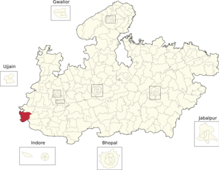
Pauri Bareli is a Bhil language of India. It is close to two other languages called Bareli, Rathwi and Palya, as well as to Kalto, but is not mutually intelligible with them.

References

  1. 1 2 3 "Jhabua". District administration. Retrieved 20 August 2010.
  2. 1 2 Ministry of Panchayati Raj (8 September 2009). "A Note on the Backward Regions Grant Fund Programme" (PDF). National Institute of Rural Development. Archived from the original (PDF) on 5 April 2012. Retrieved 27 September 2011.
  3. "Table A-02 Decadal Variation in Population Since 1901: Madhya Pradesh" (PDF). census.gov.in. Registrar General and Census Commissioner of India.
  4. "Table C-01 Population By Religion: Madhya Pradesh". census.gov.in. Registrar General and Census Commissioner of India.
  5. 1 2 3 4 5 6 "District Census Handbook: Jhabua" (PDF). Census of India . Registrar General and Census Commissioner of India. 2011.
  6. US Directorate of Intelligence. "Country Comparison:Population". Archived from the original on 13 June 2007. Retrieved 1 October 2011. Cyprus 1,120,489 July 2011 est.
  7. "2010 Resident Population Data". U. S. Census Bureau. Archived from the original on 19 October 2013. Retrieved 30 September 2011. Montana 989,415
  8. "Population, decadal growth rate, sex ratio and density – States/Union territories and Districts : 2001". Table 1. Education for all in India, Source:Registrar General of India, Government of India, New Delhi. Archived from the original on 17 September 2009. Retrieved 12 August 2010.
  9. 1 2 "Table C-16 Population by Mother Tongue: Madhya Pradesh". censusindia.gov.in. Registrar General and Census Commissioner of India.
  10. M. Paul Lewis, ed. (2009). "Bareli, Rathwi: A language of India". Ethnologue: Languages of the World (16th ed.). Dallas, Texas: SIL International. Retrieved 28 September 2011.
  11. M. Paul Lewis, ed. (2009). "Bhilali: A language of India". Ethnologue: Languages of the World (16th ed.). Dallas, Texas: SIL International. Retrieved 30 September 2011.
  12. "Seminar On Progress Of Literacy In India: What The Census 2001 Preveals Niepa, New Delhi, October 05, 2002". India’s Literacy Panorama. educationforallinindia.com. Retrieved 17 August 2010.

22°46′00″N74°36′00″E / 22.7667°N 74.6°E / 22.7667; 74.6