
The Central Provinces and Berar was a province of British India and later the Dominion of India which existed from 1903 to 1950. It was formed by the merger of the Central Provinces with the province of Berar, which was territory leased by the British from the Hyderabad State. Through an agreement signed on 5 November 1902, 6th Nizam Mahbub Ali Khan, Asaf Jah VI leased Berar permanently to the British for an annual payment of 25 lakhs Rupees. Lord Curzon decided to merge Berar with the Central Provinces, and this was proclaimed on 17 September 1903.

Mahakoshal is a region of central India. Mahakoshal lies in the upper or eastern reaches of the Narmada River valley in the Indian state of Madhya Pradesh. Jabalpur is the largest city in the region. Nimar region lies to the west, in the lower reaches of the Narmada valley.

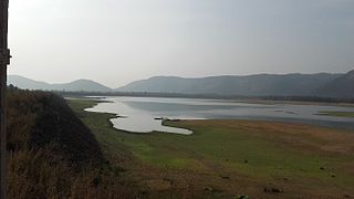
The Wainganga is a river in India originating in the Mahadeo Hills in Mundara near the village Gopalganj in Seoni, Madhya Pradesh. It is a key tributary of the Godavari. The river flows south in a winding course through the states of Madhya Pradesh and Maharashtra, roughly 579 km (360 mi). After joining the Wardha River, the united stream, which is known as the Pranahita River, empties into the Godavari River at Kaleshwaram, Telangana.

Mandla is a town with municipality in Mandla district in the Indian state of Madhya Pradesh. It is the administrative headquarters of Mandla District. The town is situated in a loop of the Narmada River, which surrounds it on three sides, and for 15 miles between Mandla and Ramnagar, Madhya Pradesh the river flows in a deep bed unbroken by rocks. The Narmada is worshiped here, and many ghats have been constructed on the banks of the river. It was a capital of the Gondwana Kingdom who built a palace and a fort, which in the absence of proper care have gone to ruins.
Balaghat district is a district of Madhya Pradesh state in Central India. The town of Balaghat serves as its administrative headquarters.

Narsinghpur district is a district of Madhya Pradesh state in central India. The city of Narsinghpur is administrative headquarters of the district. As of 2001 Narsinghpur is the most literate district of MP. Village Singhpur bada in Narsinghpur is also considered as bahubali's and goon's village
Seoni District is a district of Madhya Pradesh state in central India. The town of Seoni is the district headquarters.
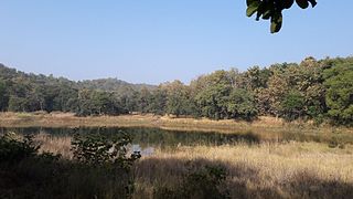
Seoni is a city and a municipality in Seoni district in the Indian state of Madhya Pradesh. This tribal household dominated district was formed in the year 1956. Rudyard Kipling used the forests in the vicinity of Seoni, or as was spelled during British colonial rule, Seeonee, as the setting for the Mowgli stories in The Jungle Book and The Second Jungle Book (1894–1895), although the area is not an actual rainforest. Seoni is city where tributary of the river Godavari, the Wainganga, originates. Seoni is reachable by road, major adjacent cities Nagpur and Jabalpur. The National Highway 44 north–south corridor crosses from Seoni. The nearest airport is in Nagpur (130 km); a small airport (air-strip) is available at Seoni near Sukhtara village for landing charter aeroplanes/helicopters.

Gondia is a city and municipal council in the Indian state of Maharashtra which serves the administrative headquarters of the eponymous administrative district. Gondia is also known as Rice City due to the abundance of rice mills in the area.
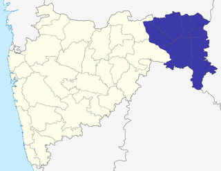
The Nagpur Division is one of six administrative divisions of the state of Maharashtra in India. Nagpur is the easternmost division in the state, with an administrative headquarters in the city of Nagpur. It covers 51,336 km² (19,821 mi²). The Amravati and Nagpur divisions make up the Vidarbha region.
Nagpur Province was a province of British India that covered parts of the present-day states of Madhya Pradesh, Maharashtra, and Chhattisgarh. The city of Nagpur was the capital of the province.
The Saugor and Nerbudda Territories, was a region of British India, located in the central part of present-day Madhya Pradesh state in central India. It included the present-day districts of Sagar (Saugor), Damoh, Jabalpur, and Narsinghpur.
The Central Provinces was a province of British India. It comprised British conquests from the Mughals and Marathas in central India, and covered parts of present-day Madhya Pradesh, Chhattisgarh and Maharashtra states. Its capital was Nagpur. It became the Central Provinces and Berar in 1903.
Ghansor is a small census town in Seoni district in the state of Madhya Pradesh,. It serves the headquarters for Janpad panchayat Ghansor. It hosts a Railway station which comes in South Eastern Central Railways zone connecting Jabalpur and Balaghat. It has a government Community Health centre and has robust government education centre with a network of schools and colleges both Private and Public .It is well connected with bus services from Lakhnadon Seoni Jabalpur Mandla. It's weather conditions are- The lowest temperature is -4°c at winter night at 3:00 am in the year 2018. The highest temperature is 52°c at 3.00 pm n 2016 in summer season
Nainpur is a town and Municipal Council in the Mandla district, of the Indian state of Madhya Pradesh.
Waraseoni is a tehsil and Nagar Palika Parishad (municipality) in Balaghat district in the Indian state of Madhya Pradesh. It is situated 16 km (10 mi) from the district headquarters. Waraseoni is second most populous town in Balaghat District after Balaghat.
Chhattisgarh Division was a former administrative division of the Central Provinces of British India. It was located in the east of the Central Provinces and encompassed the upper Mahanadi River basin, in the central part of present-day Chhattisgarh state of India.

Rani Durgavati Vishwavidyalaya, also known as University of Jabalpur, is a government university in Jabalpur, Madhya Pradesh, India. It was named after the queen Rani Durgavati. It is the main university of this D by the National Assessment and Accreditation Council (NAAC).
Keolari is a town and a tehsil in Seoni district in the state of Madhya Pradesh, India. The confluence of the Wainganga and Sagar rivers is located at Keolari. The town has a District Institute of Education Training. (D.I.E.T.).
The Jubbulpore Division, named after its capital Jabalpur (Jubbulpore), was one of the four former administrative divisions of the Central Provinces of British India. It was located in the Mahakoshal region of present-day Madhya Pradesh state of India. The Jubbulpore Division had an area of 48,401 km² with a population of 2,201,633 in 1881.
