
Harda is a town and a municipality in Harda district in the Indian state of Madhya Pradesh. Harda is the administrative headquarters of Harda. Betul city is 125 km far from main city.
Malvi, or Malwi, is an Indo-Aryan language spoken in the Malwa region of India. It is closely related to Nimadi, which is spoken in the Nimar region of Madhya Pradesh.
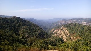
Betul is a district and municipality in southern Madhya Pradesh, India. It is the administrative center of its eponymous district and forms the southernmost part of the Bhopal Division in the Betul. Bhimpur village, located 45 km west of Betul, is the site of proposed 2800 MW Nuclear Power plant.

Bhusawal also spelled as Bhusaval is a city as well as a municipal council in the Jalgaon district in the Indian state of Maharashtra. Bhusawal is the largest Taluka in the Jalgaon district, the city is divided into 47 wards and area covered under the city is 13.38 sq. km.
Betul district is a district of Madhya Pradesh state in central India. The city of Betul serves as its administrative headquarters. The district is a part of Narmadapuram Division.

Harda District is a district of Madhya Pradesh state of central India. The town of Harda is the district headquarters. The district is part of Narmadapuram Division. Harda district was organized in 1998.Harda is also known as 'Hridaynagari'.

Chhindwara district is one of the major districts of Madhya Pradesh state of India, and Chhindwara town is the district headquarters. Chhindwara is the largest district in Madhya Pradesh with an area of 11,815 square km. The district is part of Jabalpur division.

Hoshangabad district, officially Narmadapuram district, is one of the districts of Madhya Pradesh state of India, and Hoshangabad town is the district headquarters.

Khandwa district, formerly known as the East Nimar district, is a district of the Madhya Pradesh state in central India. The city of Khandwa is the administrative headquarters of the district. Other notable towns in the district include Mundi, Harsud, Pandhana and Omkareshwar.
Betul-Bazar is a town and a nagar panchayat in Betul district in the state of Madhya Pradesh, India. During the rule of the Maratha Empire Betul-Bazar was the district headquarters of the current Betul district. In 1822 the district administration shifted to the current Betul town. Hence the Betul district and Betul-Bazar is rich in Marathi people and culture.
Chicholi is a census town and a municipal committee in Betul district in the state of Madhya Pradesh, India. Most of its people depend on farming and business. This city is surrounded by three lakes and two small rivers. Famous Hindu Temple Chandi Mata is situated in chicholi tehsil. Famous Bhoot Mela at malajpur village is just 7 km away from the chicholi. Wheat maze soyabean are the main crops of the town. Average rainfall of the chicholi is 1053mm per year. Highest Temperature is about to 45~47℃ and lowest is approx 4~5℃. Nearest Railway station is Betul Railway station.
Morshi is the second largest town in the Amravati district of Maharashtra. It is located 55 km north-east of Amravati, Situated very close to Madhya Pradesh Border, in the scenic southern foothills of Satpura ranges. Morshi and the surrounding region is also known for the cultivation of famous Nagpur oranges and famous Nal Damayanti Dam.
Multai is a town and a Nagar Palika in Betul district in the Indian state of Madhya Pradesh. Multai is one of the southern cities of Madhya Pradesh, occupying almost half of the Satpura plateau. Considering the small villages around, it occupies a large area in width of the Satpura range between the valley of the Narmada on the north and the barer plains on the south. Forests lie to the west of the city between the districts of East Nimar and Amaraoti. It lies on the Northern bank of the Tapti and the place is also known for tapti river origin place.
Amla is a municipality located in Betul district in the Indian state of Madhya Pradesh. It is the administrative center and only municipality of the Amla Subdivision.

There are 46 recognized Scheduled Tribes in Madhya Pradesh, India, three of which have been identified as 'Particularly Vulnerable Tribal Groups (PTGs)(formerly known as 'Special Primitive Tribal Groups'). The population of Scheduled Tribals (ST) is 21.1% of the state population, according to the 2011 census. Bounded by the Narmada River to the north and the Godavari River to the southeast, tribal peoples occupy the slopes of the region's mountains.

Betul railway station is a railway station serving Betul town and district of Madhya Pradesh State of India. It is under Nagpur CR railway division of Central Railway Zone of Indian Railways.

Ghoradongri Vidhan Sabha constituency is one of the 230 Vidhan Sabha constituencies of Madhya Pradesh state in central India. Ghoradingei comes under Betul. It is a reserved seat for the Scheduled tribes (ST).

Betul is one of the 230 Vidhan Sabha constituencies of Madhya Pradesh state in central India.

The Ambadevi rock shelters are part of an extensive cave site, where the oldest yet known traces of human life in the central province of the Indian subcontinent were discovered. The site is located in the Satpura Range of the Gawilgarh Hills in Betul District of the Indian state of Madhya Pradesh, north of Dharul village in Amravati district of Maharashtra. Studies of various rock paintings and petroglyphs present in the caves suggest, that the Ambadevi rock shelters were inhabited by prehistoric human settlers since around 25,000 years ago. First discoveries of clusters of numerous rock shelters and caves were made by Dr. Vijay Ingole and his team beginning on 27 January 2007. Named after the nearby ancient Ambadevi Cave Temple, the site has also been referred to as the Satpura-Tapti valley caves and the Gavilgarh-Betul rock shelters. The Ambadevi rock shelters rank among the most important archaeological discoveries of the early 21st Century in India, on par with the 20th Century discovery of the Bhimbetka rock shelters.
