
In geography, latitude is a geographic coordinate that specifies the north–south position of a point on the Earth's surface. Latitude is an angle which ranges from 0° at the Equator to 90° at the poles. Lines of constant latitude, or parallels, run east–west as circles parallel to the equator. Latitude is used together with longitude to specify the precise location of features on the surface of the Earth. On its own, the term latitude should be taken to be the geodetic latitude as defined below. Briefly, geodetic latitude at a point is the angle formed by the vector perpendicular to the ellipsoidal surface from that point, and the equatorial plane. Also defined are six auxiliary latitudes that are used in special applications.
Longitude, is a geographic coordinate that specifies the east–west position of a point on the Earth's surface, or the surface of a celestial body. It is an angular measurement, usually expressed in degrees and denoted by the Greek letter lambda (λ). Meridians connect points with the same longitude. The prime meridian, which passes near the Royal Observatory, Greenwich, England, is defined as 0° longitude by convention. Positive longitudes are east of the prime meridian, and negative ones are west.
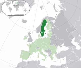
Sweden is a country in Northern Europe on the Scandinavian Peninsula. It borders Norway to the west; Finland to the northeast; and the Baltic Sea and Gulf of Bothnia to the south and east. At 450,295 km2 (173,860 sq mi), Sweden is the largest country in Northern Europe, the fifth largest in Europe, and the 55th largest country in the world.

A geographic coordinate system (GCS) is a coordinate system associated with positions on Earth. A GCS can give positions:
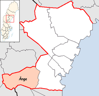
Ånge Municipality is a municipality in Västernorrland County, northern Sweden. Its seat is located in Ånge.

Medelpad is a historical province or landskap in the north of Sweden. It borders Hälsingland, Härjedalen, Jämtland, Ångermanland and the Gulf of Bothnia.

The extreme points of Norway include the coordinates that are farther north, south, east or west than any other location in Norway; and the highest and the lowest altitudes in the country. The northernmost point is Rossøya on Svalbard, the southernmost is Pysen in Mandal, the easternmost is Kræmerpynten on Svalbard, and the westernmost is Hoybergodden on Jan Mayen. The highest peak is Galdhøpiggen, standing at 2,469 m (8,100 ft) above mean sea level, while the lowest elevation is sea level at the coast.

The location of the geographical centre of Europe depends on the definition of the borders of Europe, mainly whether remote islands are included to define the extreme points of Europe, and on the method of calculating the final result. Thus, several places claim to host this hypothetical centre.

In demographics, the center of population of a region is a geographical point that describes a centerpoint of the region's population. There are several different ways of defining such a "center point", leading to different geographical locations; these are often confused.
The Universal Transverse Mercator (UTM) is a system for assigning coordinates to locations on the surface of the Earth. Like the traditional method of latitude and longitude, it is a horizontal position representation, which means it ignores altitude and treats the earth as a perfect ellipsoid. However, it differs from global latitude/longitude in that it divides earth into 60 zones and projects each to the plane as a basis for its coordinates. Specifying a location means specifying the zone and the x, y coordinate in that plane. The projection from spheroid to a UTM zone is some parameterization of the transverse Mercator projection. The parameters vary by nation or region or mapping system.
Veckans Affärer was a Swedish business magazine published on a weekly basis in Stockholm, dealing in all business-related matters both within and outside Sweden.

The Chamberlin trimetric projection is a map projection where three points are fixed on the globe and the points on the sphere are mapped onto a plane by triangulation. It was developed in 1946 by Wellman Chamberlin for the National Geographic Society. Chamberlin was chief cartographer for the Society from 1964 to 1971. The projection's principal feature is that it compromises between distortions of area, direction, and distance. A Chamberlin trimetric map therefore gives an excellent overall sense of the region being mapped. Many National Geographic Society maps of single continents use this projection.

Börringekloster Castle, formerly Börringe Priory is a castle built in 1763 on the ruins of a medieval Benedictine priory at Svedala in Scania, Sweden.
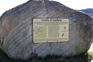
There is some debate as to the location of the geographical centre of Scotland. This is due to different methods of calculating the centre, and whether surrounding islands are included.
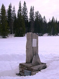
The geographical centre of Norway has been identified as a spot in the Ogndalsfjella in the southeastern part of the municipality of Steinkjer in Trøndelag county, located at 63°59′26″N12°18′28″E. A monument marking the significance of the spot was unveiled in a ceremony on 3 September 2006, with the hope that it would become a tourist attraction. The site lies just to the west of the large lake Skjækervatnet.
In geography, the centroid of the two-dimensional shape of a region of the Earth's surface is known as its geographic centre or geographical centre or gravitational centre. Informally, determining the centroid is often described as finding the point upon which the shape would balance. This method is also sometimes described as the "gravitational method".
Geographical distance is the distance measured along the surface of the earth. The formulae in this article calculate distances between points which are defined by geographical coordinates in terms of latitude and longitude. This distance is an element in solving the second (inverse) geodetic problem.

Centre points of Australia are those geographical locations that have been considered to be centre of Australia, as distinct from the extreme points of Australia.
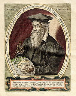
The Mercator world map of 1569 is titled Nova et Aucta Orbis Terrae Descriptio ad Usum Navigantium Emendate Accommodata. The title shows that Gerardus Mercator aimed to present contemporary knowledge of the geography of the world and at the same time 'correct' the chart to be more useful to sailors. This 'correction', whereby constant bearing sailing courses on the sphere are mapped to straight lines on the plane map, characterizes the Mercator projection. While the map's geography has been superseded by modern knowledge, its projection proved to be one of the most significant advances in the history of cartography, inspiring map historian Nordenskiöld to write "The master of Rupelmonde stands unsurpassed in the history of cartography since the time of Ptolemy." The projection heralded a new era in the evolution of navigation maps and charts and it is still their basis.
