Kurwai is a town and a Nagar Panchayat in Vidisha district in the Indian state of Madhya Pradesh. its also tehsil headquarter and assembly constituency.

Sidhi is a town and a municipality in Sidhi district in the Indian state of Madhya Pradesh. It is the headquarters of the Sidhi district.
Sardarpur is a town and a nagar panchayat in Dhar district in the Indian state of Madhya Pradesh. It is a town on Mahi river on the Malwa plateau. There is an ancient Shivalinga situated at the bank of Mahi river at a place called Shree Jhineshwar Dham; Shri Mohankheda Jain Thirth and Bhopawar Jain Tirth are located nearby.
Bhander is a town and a nagar panchayat in Datia district in the state of Madhya Pradesh.
Jeron Khalsa is a town and a gram panchayat in Niwari district in the Indian state of Madhya Pradesh.
Kasrawad is a tehsil and nagar panchayat in Khargone district in the Indian state of Madhya Pradesh. Kasrawad Assembly constituency is one of the 230 Vidhan Sabha constituencies of Madhya Pradesh state in central India.
Mahroni is a town and a nagar panchayat in Lalitpur district in the Indian state of Uttar Pradesh. It is one of the tehsils of Lalitpur District also a legislative assembly constituency Mehroni Assembly constituency and is situated 37 km away from Lalitpur. It is very close to Madhya Pradesh and Uttar Pradesh border. Twitter
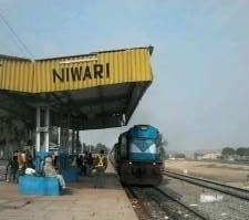
Niwari is a town and a nagar panchayat in Niwari district in the Indian state of Madhya Pradesh. It is the administrative headquarters of Niwari district.
Rajakhera is a city and a municipality situated near the banks of the Chambal River in Dholpur district in the Eastern part of the Indian state of Rajasthan. Its part of Braj region and the local language has Braj Bhasha dialect. The culture is fused with Rajasthan and its border states.
Sihora is a town and a municipality in Jabalpur district in the Indian state of Madhya Pradesh. Sihora is located at 23.48°N 80.12°E. The first cooperative society in Madhya Pradesh state was established in Sihora block of Jabalpur district in 1904.
Susner is a town and a Nagar panchayat and Sub division in Agar Malwa district in the Madhya pradesh state of India. Its also a tehsil and a assembly.
Pichhore is a town and a nagar panchayat in Shivpuri district in the Indian state of Madhya Pradesh.It is Also linked with Train route from Basai railway station situated 35 km from Pichhore.Also it is situated in Bundelkhand region of MP.

Tikamgarh Assembly constituency is one of the 230 Vidhan Sabha constituencies of Madhya Pradesh state in central India. This constituency came into existence in 1951, as one of the 48 Vidhan Sabha constituencies of the erstwhile Vindhya Pradesh state.

Jatara is one of the 230 Vidhan Sabha constituencies of Madhya Pradesh state in central India. This constituency is reserved for the candidates belonging to the Scheduled castes since 2008, following the delimitation of the legislative assembly constituencies. It came into existence in 1951, as one of the 48 Vidhan Sabha constituencies of the erstwhile Vindhya Pradesh state.

Prithvipur Assembly constituency is one of the 230 Vidhan Sabha constituencies of Madhya Pradesh state in central India. Initially, it came into existence in 1951 as one of the 48 Vidhan Sabha constituencies of the erstwhile Vindhya Pradesh state, but it was abolished in 1956. This constituency again came into existence in 2008, following the delimitation of the legislative assembly constituencies. Prithvipur is small town of Bundelkhand. It's a city of politics.

Niwari Assembly constituency is one of the 230 Vidhan Sabha constituencies of Madhya Pradesh state in central India. This constituency came into existence in 1951, as one of the 48 Vidhan Sabha constituencies of the erstwhile Vindhya Pradesh state.

Khargapur Assembly constituency is one of the 230 Vidhan Sabha constituencies of Madhya Pradesh state in central India. This constituency came into existence in 1967, following the delimitation of the Legislative Assembly constituencies and it was reserved for the candidates belonging to the scheduled castes from 1967 to 2008.
Bhamoura Khas is a village and a gram panchayat in Niwari Tehsil in the Tikamgarh district in the Indian state of Madhya Pradesh. Bhamoura Khas belongs to the Sagar Division. It is located 78 kilometers north from the district headquarters Tikamgarh and 317 kilometers from the state capital Bhopal. Bhamoura Khas is on the border of the Tikamgarh District and Jhansi District. Bhamoura Khas is surrounded by Prithvipur Tehsil on the South, Mauranipur Tehsil on the East, and Chirgaon Tehsil on the North.

Parasia is one of the 230 Legislative Assembly constituencies of Madhya Pradesh state in central India.
Niwari district is one of the 52 districts of the Madhya Pradesh state in India. Niwari is administrative headquarter of Niwari district.

