
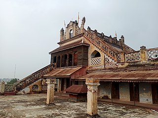
Bithoor or Bithur is a town in Kanpur district, 23.4 kilometres (14.5 mi) by road north of the centre of Kanpur city, in Uttar Pradesh, India. Bithoor is situated on the right bank of the River Ganges, and is a centre of Hindu pilgrimage. Bithoor is also the centre for War of Independence of 1857 as Nana Sahib, a popular freedom fighter who was based there. The city is enlisted as a municipality of Kanpur metropolitan area.
Murtijapur is a Municipal council and one of the taluka of district of Akola of the Amravati division of the Vidarbha region of Maharashtra.
Nabha is a town and municipal council in the Patiala district in the south-west of the Indian state of Punjab. It was the capital of the former Nabha State. Nabha is also a sub-division city which comes under Patiala district.
Baldeo is a town and a nagar panchayat in Mathura district in the state of Uttar Pradesh, India.
Budhgaon is a census town in Sangli district in the state of Maharashtra, India.
Doharighat is a town and a nagar panchayat in Mau district in the state of Uttar Pradesh, India.
Gagret is a nagar panchayat in Tehsil Ghanari of Una district in the state of Himachal Pradesh, India. It is situated in plains of Jaswan valley of Una.
Jaspur is a developing town and a municipal board in Udham Singh Nagar district in the Indian state of Uttarakhand.
Jintur city and a municipal council in Parbhani district in the Indian state of Maharashtra.
Kora Jahanabad is a town in Fatehpur district and in Indian state of Uttar Pradesh. It is located on Kora Road, about 6 km east of Jahanabad, about 43 km south of Kanpur, 78 km west by northwest of Fatehpur, and 480 km southeast of Delhi. Local people also call it "Jahanabad".
Lalsot is a city with municipality in Dausa district in the Indian state of Rajasthan. Lalsot is the biggest city in Dausa district.

Maniyar is a town and a Nagar Panchayat in Ballia district in the Indian state of Uttar Pradesh. It is also called Parshuram Nagari.
Obedullaganj is a town and a nagar panchayat in Raisen district in the Indian state of Madhya Pradesh. It is situated 70 km from its district headquarter Raisen and 36 km from its state capital city Bhopal.

Pandhurna is the administrative headquarter of the Pandhurna District in Madhya Pradesh, India. Pandhurna city is an important city from the business point of view. The famous Gotmar Fair is organized every year on the banks of Jam River. Pandhurna is also famous for its orange fields. Pandhurna also has a multinational company called drytech situated at Nagpur road.

Rehli is a city and a municipality in Sagar district in the Indian state of Madhya Pradesh. it's also a tehsil headquarter.
Reoti is a town and a nagar panchayat in Ballia district in the Indian state of Uttar Pradesh. Known for got freedom before 1947 As usual India had got freedom on 15 Aug 1947 but all across the India Reoti town got freedom in 1942.
Soyat Kalan or Soyat is a town and a Nagar Parishad in Agar Malwa district in the Indian state of Madhya Pradesh.
Weir is a town and a municipality in Bharatpur District in the Indian state of Rajasthan.
Faridpur is a town and a small Nagar Palika and tehsil in Bareilly district in the Indian state of Uttar Pradesh. Faridpur is known for zari work. It comes under 122 Legislative assembly. Current M.L.A. is Professor Shyam Bihari Lal and M.P. is Mr. Dharmendra Kashyap. Nagarpalika Chairman of Faridpur is Mr Sharaf Zari Wale
Nagar is a village in the Phillaur tehsil of Jalandhar District of the Indian state of Punjab. It is located on Phillaur-Nawanshahr Road, 6.7 kilometres (4.2 mi) from the head postal office in Phillaur, 7 kilometres (4.3 mi) from Apra, 50 kilometres (31 mi) from Jalandhar, and 117 kilometres (73 mi) from the state capital of Chandigarh. The village is administered by the Sarpanch, an elected representative.

