
Abu'l Hasan Yamīn ud-Dīn Khusrau, better known as Amīr Khusrau, was an Indo-Persian Sufi singer, musician, poet and scholar who lived during the period of the Delhi Sultanate.
Nakur is a town, tehsil and a municipal board in Saharanpur district in the Indian state of Uttar Pradesh.

Mandu or Mandavgad is an ancient city in the present-day Mandav area of the Dhar district. It is located in the Malwa and Nimar region of western Madhya Pradesh, India, at 35 km from Dhar city. In the 11th century, Mandu was the sub division of the Tarangagadh or Taranga kingdom. This fortress town on a rocky outcrop about 100 km (62 mi) from Indore is celebrated for its architecture.

Shams ud-Din Iltutmish was the third of the Mamluk kings who ruled the former Ghurid territories in northern India. He was the first Muslim sovereign to rule from Delhi, and is thus considered the effective founder of the Delhi Sultanate.
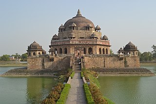
Sasaram, also spelled as Sahasram, is a historical city and a municipal corporation region in the Rohtas district of Bihar state in eastern India.

The Khalji or Khilji dynasty was the second dynasty which ruled the Delhi sultanate, covering large parts of the Indian subcontinent for nearly three decades between 1290 and 1320. It was founded by Jalal ud din Firuz Khalji.

Ghiyath al-Din Tughluq, or Ghazi Malik was the Sultan of Delhi from 1320 to 1325. He was the first sultan of the Tughluq dynasty of the Delhi Sultanate. During his reign, Ghiyath al-Din Tughluq founded the city of Tughluqabad. His reign ending upon his death in 1325 when a pavilion built in his honour collapsed. The 14th century historian Ibn Battuta claimed that the death of the sultan was the result of a conspiracy against him

Jalal-ud-Din Khalji, also known as Firuz al-Din Khalji or Jalaluddin Khilji was the founder and first Sultan of the Khalji dynasty that ruled the Delhi Sultanate from 1290 to 1320.
Budaun is a medieval city and headquarters of Budaun district, Uttar Pradesh, India. It is located about a mile east of the Sot river, and 27 km north of the river Ganges, in the Rohilkhand region of Uttar Pradesh. According to the 2011 census, it has a total population of 159,221, which is projected at 161,555 at present. Budaun rose to historical importance as the capital of the Delhi Sultanate for four years from 1210 CE to 1214 CE during the reign of Sultan Iltutmish. It was the most important post of Northern Frontier during Mughal reign. Budaun is a big market, historically famous and religiously important city. Budaun is 230 km south-east of New Delhi and 245 km north-west of Lucknow, both taking about 6 hours by road.

Badaun district is one of the districts of Uttar Pradesh state of India, with its headquarters in the town of Badaun. The district is part of the Bareilly division, and covers an area of 4,234 km2 (1,635 sq mi). According to legend, Budaun was named after the Ahir prince Budh.

Pilibhit district is one of the 75 districts in the state of Uttar Pradesh in India, and Pilibhit city is the district headquarters. Pilibhit district is a part of Bareilly Division. A Tiger Reserve Area was named Pilibhit Tiger Reserve in September 2008.

Shahjahanpur is a district of Uttar Pradesh India. It is a part of Bareilly division. It was established in 1813 by the British Government. Previously it was a part of district Bareilly. Geographically the main town is Shahjahanpur which is its headquarters. Its 4 Tehsils are: Powayan, Tilhar, Jalalabad and Sadar.
Gopamau is a town and nagar panchayat in Hardoi district, Uttar Pradesh, India. Located just west of the Gomti river, Gopamau is a historic town that once served as a pargana headquarters. Important industries include cap making, tobacco, and agricultural products. As of 2011, the population of Gopamau is 15,526, in 2,346 households. The town has several slum areas, which are home to 36.07% of town residents.
Jarwal is a town and a nagar panchayat in Bahraich district in the Indian state of Uttar Pradesh. It has an average elevation of 117 metres (383 feet). This place is 20 km away from historical Lodheshwar Mahadev Mandir located in Mahadeva Ram Nagar, that is well described in old mythological stories.
Patiyali is a town and a nagar panchayat in Kasganj District in the Indian state of Uttar Pradesh. It is located on the banks of River Ganga. It is the birthplace of Amir Khusrau. Patiyali is a constituency of District Kasganj. Member of Legislative Assembly from Patiyali is Nadira Sultan of Samajwadi Party. About hundred years ago the river Ganges flowed thorough Patiyali Quila.Patiyali Quila is a Quila of Raja Durpad from Mahabharat time. Nowadays it is 10 km away at Qadarganj. Dariyaganj lake of Patiyali covers an area of about 50 hectares. On the occasion of Kakode ka Mela thousands of people assemble at Kaderganj Ghat.

Ghoraghat is an upazila of Dinajpur District in the Division of Rangpur, Bangladesh.
Shahi is a town and a nagar panchayat in Bareilly district in the Indian state of Uttar Pradesh.Shahi is the one of most old British town areas First Chairman of Town Shahi is Haji Nadir Shah khan in 1868 after him his Son Khan bahadur Mohammed Raza Khan is Chairman and M.L.A of bareilly he is also Chairman of district Board Bareilly, after Mohammed Raza Khan death his son Hamid Raza Khan is also became Chairman and M.L.A of Bhojipura Constituency he is a Famous politician after his death in 1989 Son of Hamid Raza Khan, Shahid Raza khan Became Chairman of Town Area Shahi for Almost 50 years
Gujarat, a region in western India, fell under Delhi Sultanate following repeated expeditions under Alauddin Khalji around the end of the 13th century. He ended the rule of Vaghela dynasty under Karna II and established Muslim rule in Gujarat. Soon the Tughluq dynasty came to power in Delhi whose emperor carried out expeditions to quell rebellion in Gujarat and established their firm control over the region by the end of the century. Following Timur's invasion of Delhi, the Delhi Sultanate weakened considerably so that the last Tughluq governor Zafar Khan declared himself independent in 1407 and formally established the Gujarat Sultanate.
‘Ayn al-Mulk Mūltānī was a military commander and official who served the Khalji and Tughluq dynasties of the Delhi Sultanate in present-day India. He served as Alauddin Khalji's governor of Malwa and Devagiri, and after Alauddin's death, suppressed a revolt in Gujarat.

Hardoi is a village in Maharajganj block of Rae Bareli district, Uttar Pradesh, India. Located on the road from Maharajganj to Bachhrawan, Hardoi historically served as the seat of a pargana and has a now-ruined fort built in the early 1400s under the Jaunpur Sultanate. As of 2011, its population is 2,308, in 415 households.

