Almora district

Last updated

Almora district
Temple Cluster at Jageshwar.jpg
1 Almora Uttarakhand India.jpg
Surya Temple2.jpg
Kumoan village(binsar wild life sanctury).jpg
Nanda Devi Peak from Ranikhet.jpg
Clockwise from top-left: Jageshwar, Almora town, Binsar Wildlife Sanctuary, Nanda Devi from Ranikhet, Surya temple Katarmal
Almora in Uttarakhand (India).svg
Location in Uttarakhand
Almora district
Almora district
Coordinates: 29°35′50″N79°39′25″E / 29.59718°N 79.6570°E / 29.59718; 79.6570
CountryFlag of India.svg  India
State Uttarakhand
Division Kumaon
Headquarters Almora
Government
   District collector Vineet Tomar IAS [1]
Area
  Total3,082 km2 (1,190 sq mi)
Elevation
1,646 m (5,400 ft)
Population
 (2011)
  Total622,506
  Density200/km2 (500/sq mi)
Time zone UTC+5:30 (IST)
PIN
263601
Telephone code91-5962
Vehicle registration UK-01
Climate Alpine (BSh) and Humid subtropical(Bsh) (Köppen)
Annual temperature28 to -2 °C
Summer temperature28 - 12 °C
Winter temperature15 to -2 °C
Website almora.nic.in

Almora is a district in the Kumaon Division of Uttarakhand state, India. The headquarters is at Almora. It is 1,638 meters above sea level. The neighbouring regions are Pithoragarh district to the east, Chamoli district to the west, Bageshwar district to the north and Nainital district to the south.

Contents

History

Administrative History of Almora District Almora district history.png
Administrative History of Almora District

The ancient town of Almora was the capital of the Kumaon Kingdom, before its establishment, it was under the possession of Katyuri king Baichaldeo. Later on when the Chand dynasty was founded in Champawat, the town of Almora was founded at this centrally located place in 1568 [2] by Kalyan Chand. Later Chand kings shifted the capital of the Kumaon Kingdom from Champawat to Almora. [3]

Almora town was the administrative headquarters of the Kumaun district; which was formed in 1815 following the defeat of Gorkha army in the Anglo-Gorkha war and the 1816 Treaty of Sugauli. The Kumaun district then consisted of the complete Kumaon Division excluding the Terai district with its headquarters at Kashipur. [4] In 1837, Garhwal was made a separate district with its headquarters at Pauri. The Nainital district was carved out of the Kumaun District in 1891, and the Kumaon District was then renamed Almora District after its headquarter.

In the 1960s Bageshwar district, Pithoragarh district and Champawat district had not yet been formed and were part of Almora district. [5] Pithoragarh district was carved out of Almora on 24 February 1960 and Bageshwar district on 15 September 1997. In 2011, Ranikhet District was proposed to be carved out of the Almora District and has yet to come into existence.

Geography

Almora ridge, 1860s Almora, 1860s.jpg
Almora ridge, 1860s

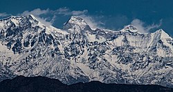
The town of Almora is situated over a horse saddle-shaped ridge of a mountain. The eastern portion of the ridge is known as Talifat and the western one is known as Selifat. The market is at the top of the ridge where these two, Talifat and Selifat jointly terminate.

The market is 1.25 miles (2.01 km) long and is covered with stone slabs. The place of the present cantonment was formerly known as Lalmandi. Presently where the collectorate exists, the 'Malla Mahal' (Upper Court) of Chanda kings was located. The site of present District Hospital used to be 'Talla Mahal' (Lower Court) of Chand rulers.[ citation needed ]

Simalkhet is a village situated on the border of Almora and Chamoli. People of this village can speak both Kumauni and Garhwali languages.[ citation needed ] On the top of a hill there is a temple called Bhairav Gadi.

There is also a village known as Shitlakhet that sits in the south quadrant. This village is a hill station. [6]

Gori River flows through Almora District.

Source: censusindia.gov.in Almora population.png
Source: censusindia.gov.in

Visitor attractions

Administrative subdivisions

District of Almora is divided into nine tehsils: Almora, Bhikiyasain, Bhanoli, Chaukhutiya, Dwarahat, Jainti, Ranikhet, Someshwar, Syalde and Sult.

Its Assembly constituencies are Dwarahat, Salt, Ranikhet, Someshwar (SC), Almora, and Jageshwar.

Culture and literature

Almora was also the site of the dance academy set up by dancer Udai Shankar in 1938 – several well-known Indian and French dancers[ who? ] trained there. The Almora dance academy was housed in Pine Lodge on the outskirts of the town (Ranidhara). The site has views of the Himalayas and the city.

"In these hills, Nature’s hospitality eclipses all that man can ever do. The enchanting beauty of the Himalayas, their bracing climate and the soothing green that envelops you, leave nothing more to be desired. I wonder whether the scenery of these hills and the climate are to be surpassed, if equalled, by any of the beauty spots of the world. After having been for nearly three weeks in the Almora hills, I am more than ever amazed why our people need to go to Europe in search of health." [7]

- Mahatma M.K. Gandhi

"These mountains are associated with the best memories of our race: Here, therefore, must be one of centers, not merely of activity, but more of calmness of meditation, and of peace and I hope some one to realize it."

- Swami Vivekananda (replying to the address given to him by the people of Almora)

Transport

The Nearest airports to Almora are Pantnagar Airport (127 km) in Nainital and Naini Saini Airport (125 km) in Pithoragarh.

The nearest railway station is at Kathgodam, 90 km, from where direct trains are available for Delhi, Lucknow and Agra. Some of the major trains from Kathgodam are:

Almora is well connected by road to important centres in the region. NH 87 passes through to almora is known as karnaprayag national highway. Some distances:

Demographics

Historical population
YearPop.±% p.a.
1901216,960    
1911251,423+1.49%
1921253,675+0.09%
1931279,009+0.96%
1941328,748+1.65%
1951369,697+1.18%
1961420,152+1.29%
1971483,876+1.42%
1981560,381+1.48%
1991610,453+0.86%
2001632,866+0.36%
2011622,506−0.16%
source: [8]

According to the 2011 census Almora district has a population of 622,506, [9] roughly equal to the nation of Montenegro [10] or the US state of Vermont. [11] This gives it a ranking of 517th in India (out of a total of 640). [9] The district has a population density of 198 inhabitants per square kilometre (510/sq mi). [9] Its population growth rate over the decade 2001-2011 was −1.73%. [9] Almora has a sex ratio of 1139 females for every 1000 males, [9] and a literacy rate of 81.06%. Scheduled Castes and Scheduled Tribes make up 22.68% and 0.21% of the population respectively. [9]

Religions in Almora district (2011) [12]
ReligionPercent
Hinduism
98.19%
Islam
1.25%
Other or not stated
0.56%
Distribution of religions

In 2001, Hindus were 621,203, Muslims 7,283 (1.15%), Christians 959. Most of the population lives near the main market of Almora that forms nearly 45% of the population. [13]

Languages of Almora district (2011) [14]

   Kumaoni (90.22%)
   Hindi (5.33%)
   Garhwali (2.88%)
  Others (1.57%)

The major first language of the district is Kumaoni, spoken by over 90% of the population. [14]

Almora district: mother-tongue of population, according to the 2011 Indian Census. [14]
Mother tongue codeMother tonguePeoplePercentage
002007 Bengali 5550.1%
004001 Dogri 7370.1%
006102 Bhojpuri 8850.1%
006195 Garhwali 17,9392.9%
006240 Hindi 33,1985.3%
006340 Kumauni 561,64290.2%
014011 Nepali 2,6040.4%
016038 Punjabi 5360.1%
022015 Urdu 1,4080.2%
Others 3,0020.5%
Total622,506100.0%

Notable people

Villages

Related Research Articles

<span class="mw-page-title-main">Kumaon division</span> Administrative division in India

Kumaon is a revenue and administrative division in the Indian State of Uttarakhand. It spans over the eastern half of the state and is bounded on the north by Tibet, on the east by Nepal, on the south by the state of Uttar Pradesh, and on the west by Garhwal. Kumaon comprises six districts of the state: Almora, Bageshwar, Champawat, Nainital, Pithoragarh and Udham Singh Nagar.

<span class="mw-page-title-main">Champawat</span> Town in Uttarakhand, India

Champawat is a town and a Nagar Palika Parishad in Champawat district in the state of Uttarakhand, India. It is the administrative headquarters of Champawat district. The town was the former capital of the Kumaon Kingdom.

<span class="mw-page-title-main">Haldwani</span> Metropolis in Uttarakhand, India

Haldwani is the largest city of Kumaon. It is also the third most populous city and largest commercial market in the Indian state of Uttarakhand. Haldwani is said to be the financial capital of Uttarakhand, having the most commercial, economic and industrial activities of the state. Haldwani is located in the Nainital District, and is one of its eight Subdivisions. The Haldwani Urban agglomeration has 232,060 people as of 2011, and is the third most populous UA in Uttarakhand, after Dehradun and Haridwar. Being situated in the immediate foothills of Kumaon Himalayas, the Kathgodam neighbourhood of Haldwani is known as the "Gateway to Kumaon".

<span class="mw-page-title-main">Kumaoni language</span> Indo-Aryan language

Kumaoni is an Indo-Aryan language spoken by over two million people of the Kumaon region of the state of Uttarakhand in northern India and parts of Doti region in Western Nepal. As per 1961 survey there were 1,030,254 Kumaoni speakers in India. The number of speakers increased to 2.2 million in 2011.

<span class="mw-page-title-main">Nanda Devi Raj Jat</span>

The three-week-long Nanda Devi Raj Jat is a pilgrimage and festival of Uttarakhand. India. The Raj-Jaat is celebrated in Chamoli Garhwal district, and traditionally only the deities of Garhwal Division took part in it. Sometimes, during the peaceful periods between the Kingdoms of Garhwal and Kumaun, the Goddess "Nanda of Almora" was invited and took part in the Raj-Jaat, while mostly there were separate Nanda-Sunanda fairs in Kumaun. Off late, after the formation of Uttarakhand, the state Government has been trying bring the people from Garhwal and Kumaun together for celebrations and fairs. Hence, in the Nanda Devi Raj Jaat held in the year 2000, the goddess "Almora ki Nanda" took part after 90 years and a number of other deities from Kumaun accompanied her. To facilitate this change, even the traditional route of the Yatra was tweaked and an additional stop with a detour was added, i.e. Nanadakesri. It is at this point, that the deities and devotees from Kumaon assimilate with the main Jaat. Now people from the entire Garhwal division-Kumaon division, as well as other parts of India and the world participate in Nanda Devi Raj Jat yatra

<span class="mw-page-title-main">Ranikhet</span> Town in Uttarakhand, India

Ranikhet is a hill station and cantonment town, near Almora Town in Almora district in the Indian state of Uttarakhand. It is the home of the Military Hospital, Kumaon Regiment (KRC) and Naga Regiment and is maintained by the Indian Army.

<span class="mw-page-title-main">Chand kings</span> Medieval Indian Chand dynasty of Kumaon

The Chand dynasty was a Hindu dynasty that ruled the Kumaon area in present-day Uttarakhand state of India, after the decline of the Katyuri rule. At times, their rule also extended to the western parts of present-day Nepal. Somchand, established the dynasty, establishing his capital at Rajbunga in present-day Champawat.

<span class="mw-page-title-main">Pithoragarh</span> Town in Kumaon division, Uttarakhand, India

Pithoragarh is a Himalayan town with a Municipal Board in Pithoragarh district in the Indian state of Uttarakhand. It is the largest hill town in Kumaon Division.

<span class="mw-page-title-main">Bageshwar district</span> District of Uttarakhand in India

Bageshwar is a district of Uttarakhand state in northern India. The town of Bageshwar is the district headquarters. Prior to its establishment as a district in 1997 it was part of Almora district.

<span class="mw-page-title-main">Bageshwar</span> Town in Uttarakhand, India

Bageshwar is a town and a municipal board in Bageshwar district in the state of Uttarakhand, India. It is located at a distance of 470 km from the National Capital New Delhi and 332 km from the State Capital Dehradun. Bageshwar is known for its scenic environment, glaciers, rivers and temples. It is also the administrative headquarters of Bageshwar district.

<span class="mw-page-title-main">Kathgodam</span> Town in Uttarakhand, India

Kathgodam is a suburb of Haldwani city in the Nainital district of Uttarakhand state of India. It used to be a part of the twin township of Haldwani-Kathgodam, and is immediately north of Haldwani. It is one of the important collection centres for forest products obtained from Kumaon Himalayas.

<span class="mw-page-title-main">Bhowali</span> Town in Uttarakhand, India

Bhowali is a town and a municipal board in Nainital District in the state of Uttarakhand, India. It is situated at a distance of 11 km (6.8 mi) from the city of Nainital, the district headquarters; at an average elevation of 1,654 m (5,427 ft) from sea level. It is the seat of Bhowali tehsil, one of the eight subdivisions of Nainital district.

<span class="mw-page-title-main">Almora</span> Town in Uttarakhand, India

Almora is a municipal board and a cantonment town in the state of Uttarakhand, India. It is the administrative headquarters of Almora district. Almora is located on a ridge at the southern edge of the Kumaon Hills of the Himalaya range. The Koshi (Kaushiki) and Suyal (Salmale) rivers flow along the city and snow-capped Himalayas can be seen in the background.

<span class="mw-page-title-main">Lohaghat</span> City in Uttarakhand, India

Lohaghat is a town and a nagar palika in Champawat district in the Indian state of Uttarakhand.

<span class="mw-page-title-main">Chaukori</span> Village in Uttarakhand, India

Chaukori is a hill station in the Pithoragarh district set among the lofty peaks of the western Himalayan Range in the Kumaon Division of Uttarakhand, India. To its north is Tibet and to its south is Terai. The Mahakali River, running along its eastern boundary, forms the Indo-Nepal international border. This place has become a prominent tourist place and from here a wide and picturesque view of Himalayan range can be viewed. The golden yellow colour of sun rays falling on the Himalayan range in the morning time is really worth seeing. There are cottages available here where one can stay and enjoy the serene surroundings. Tourists coming to this place generally also visit the nearby tourist places like Patal Bhuvaneshwar, Kausani, Bageshwar and Almora.

<span class="mw-page-title-main">Kausani</span> Hill Station in Uttarakhand, India

Kausani is a hill station and Village situated in Bageshwar district in the state of Uttarakhand, India. It is famous for its scenic splendour and its spectacular 300 km-wide panoramic view of Himalayan peaks like Trisul, Nanda Devi and Panchchuli. Mahatma Gandhi called this place the 'Switzerland of India', due to similarity in landscapes.

<span class="mw-page-title-main">Baijnath, Uttarakhand</span> Town in Uttarakhand, India

Baijnath is a small town on the banks of the Gomati river in the Bageshwar district in Kumaon division of Uttarakhand, India. The place is most noted for its ancient temples, which have been recognized as Monuments of National Importance by the Archaeological Survey of India in Uttarakhand. Baijnath has been selected as one of the four places to be connected by the 'Shiva Heritage Circuit' in Kumaon, under the Swadesh Darshan Scheme of the Government of India.

<span class="mw-page-title-main">Kathgodam railway station</span> Indian railway station

Kathgodam railway station is railway station located in Kathgodam town near Haldwani, just 35 km from Nainital Town in Nainital district of Uttarakhand State of India.

<span class="mw-page-title-main">Outline of Uttarakhand</span> Overview of and topical guide to Uttarakhand

The following outline is provided as an overview of and topical guide to Uttarakhand:

<span class="mw-page-title-main">Sarju</span> River in Uttarakhand, India

The Sarju, also known as Sarayu, is a major river draining Central Kumaon region in the Indian state of Uttarakhand. Originating from Sarmul, Sarju flows through the cities of Kapkot, Bageshwar and Seraghat before joining Mahakali at Pancheshwar. The Sarju is the largest tributary of the Sharda River. The river forms the South-eastern border between the districts of Pithoragarh and Almora. Temperate and sub-Tropical forests cover the entire Catchment area of the River.

References

  1. "DM Profile | District Almora, Government of Uttarakhand | India" . Retrieved 4 July 2023.
  2. "Almora history". Archived from the original on 14 October 2008. Retrieved 21 December 2007.
  3. Atkinson, Edwin Thomas (1981). The Himalayan gazetteer. Cosmo Publications. OCLC   833450501.
  4. Martin, Robert Montgomery. History of the Possessions of the Honourable East India Company, Volume 1. p. 107.
  5. Times World Atlas, 1967 Edition, Plate 30.
  6. Mazumdar, Ankita (29 December 2023). "Immerse In Kumaoni Culture At This Luxurious Stay In Uttarakhand's Shitlakhet With Lofty Peak Views". Curly Tales. Retrieved 16 January 2024.
  7. "The Collected Works of Mahatma Gandhi Vol. 46: 12 May 1929 – 31 August 1929" (PDF)., p. 254
  8. Decadal Variation In Population Since 1901
  9. 1 2 3 4 5 6 "District Census 2011". Census2011.co.in. 2011. Retrieved 30 September 2011.
  10. US Directorate of Intelligence. "Country Comparison:Population". Archived from the original on 13 June 2007. Retrieved 1 October 2011. Montenegro 661,807 July 2011 est.
  11. "2010 Resident Population Data". U. S. Census Bureau. Archived from the original on 19 October 2013. Retrieved 30 September 2011. Vermont 625,741
  12. "Table C-01 Population by Religion: Uttarakhand". censusindia.gov.in. Registrar General and Census Commissioner of India. 2011.
  13. "Uttarakhand - Districts of India: Know India". National Portal of India. Archived from the original on 19 February 2009. Retrieved 4 April 2009.
  14. 1 2 3 "Table C-16 Population by Mother Tongue: Uttarakhand". www.censusindia.gov.in. Registrar General and Census Commissioner of India.
  15. 1 2 WRITERS AND THEIR WORKS Foundation of SAARC Writers. Archived 2 April 2010 at the Wayback Machine
  16. "Daulaghat, Almora". RotarMaps.com. Retrieved 12 May 2023.