Related Research Articles

Uttarakhand, formerly known as Uttaranchal, is a state in the northern part of India. It is often referred to as the "Devbhumi" due to its religious significance and numerous Hindu temples and pilgrimage centres found throughout the state. Uttarakhand is known for the natural environment of the Himalayas, the Bhabar and the Terai regions. It borders the Tibet Autonomous Region of China to the north; the Sudurpashchim Province of Nepal to the east; the Indian states of Uttar Pradesh to the south and Himachal Pradesh to the west and north-west. The state is divided into two divisions, Garhwal and Kumaon with a total of 13 districts. The winter capital of Uttarakhand is Dehradun, the largest city of the state, which is a rail head. Bhararisen, a town in Chamoli district is the summer capital of Uttarakhand. The High Court of the state is located in Nainital.

Haldwani is the third most populous city, and largest commercial market in the Indian state of Uttarakhand. It is also the largest city of the Kumaon region. Haldwani is said to be the financial capital of Uttarakhand, having the most commercial, economic and industrial activities of the state. Haldwani is located in the Nainital District, and is one of its eight Subdivisions. The Haldwani Urban agglomeration has 232,060 people as of 2011, and is the fourth most populous UA in Uttarakhand, after Dehradun, Haridwar and Roorkee. Being situated in the immediate foothills of Kumaon Himalayas, the Kathgodam neighbourhood of Haldwani is known as the "Gateway to Kumaon".

Roorkee (Rūṛkī) is a city in North India and a municipal corporation in the Haridwar district of the state of Uttarakhand, India. It is spread over a flat terrain under Sivalik Hills of Himalayas. The city is developed on the banks of Ganges Canal, its dominant feature, which flows from north–south through middle of the city. Roorkee is home to Asia's first engineering college Indian Institute of Technology Roorkee, formerly known as Thomson College of Civil Engineering. Roorkee is also known for the Roorkee Cantonment, one of the country's oldest military establishments and the headquarters of Bengal Engineer Group since 1853. Roorkee has the distinction of being one of the endpoints of the first train journey in India on 22 December 1851.

Udham Singh Nagar District is a district of Uttarakhand state in northern India. Rudrapur is the district headquarters. This district consists of seven Tehsils named Bajpur, Gadarpur, Jaspur, Kashipur, Kichha, Khatima, Sitarganj. The district is located in the Terai region, and is part of Kumaon Division. It is bounded on the north by Nainital District, on the northeast by Champawat District, on the east by Nepal, and on the south and west by Bareilly, Rampur, Moradabad, Pilibhit and Bijnor District of Uttar Pradesh state. The district was created on 29 September 1995, by Mayawati government out of Nainital District. It is named for freedom fighter and Indian revolutionary Udham Singh.

Gairsain is a town in Chamoli district of the Indian state of Uttarakhand near state's summer capital Bhararisen. A town and Nagar Panchayat, Gairsain is situated at the eastern edge of the vast Dudhatoli mountain range, and is located in Chamoli district almost at the centre of the state, at a distance of approximately 250 kilometres from Dehradun. It is easily accessible from both the Garhwal and the Kumaon divisions, and in a way, acts as the bridge between the two regions. It is being considered as the future Permanent capital of Uttarakhand.
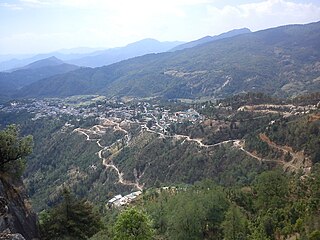
Didihat is a town and a Nagar Palika in Pithoragarh District in the state of Uttarakhand, India. It is one of the eleven administrative subdivisions of Pithoragarh district and also serves as its administrative headquarter. With a population of 6522, Didihat is located at a distance of 415 km (258 mi) from the state capital Dehradun.

Nainital district is a district in Kumaon division which is a part of Uttarakhand state, India. The headquarters is at Nainital.

Tehri Garhwal is a district in the hill state of Uttarakhand, India. Its administrative headquarters is at New Tehri. The district has a population of 618, 931, a 2.35% increase over the previous decade. It is surrounded by Rudraprayag District in the east, Dehradun District in the west, Uttarkashi District in the north, and Pauri Garhwal District in the south. Tehri Garhwal is a part of the Himalayas

Champawat district is a district of Uttarakhand state in northern India. The town of Champawat is the administrative headquarters. The district of Champawat constituted in the year 1997. The district is divided into five tehsils: Barakot, Lohaghat, Pati, Purnagiri.

Bageshwar is a district of Uttarakhand state in northern India. The town of Bageshwar is the district headquarters. Prior to its establishment as a district in 1997 it was part of Almora district.
Kashipur is a city of Udham Singh Nagar district in the Indian state of Uttarakhand, and one of its seven subdivisions. Located in the western part of Udham Singh Nagar district, it is Kumaun's third most populous city and the sixth most populous in Uttarakhand. According to the 2011 Census of India, the population is 121,623 for the city of Kashipur and 283,136 for Kashipur Tehsil. Kashipur also has IIM Kashipur, one of the thirteen Indian Institutes of Managements the government has set up during the Eleventh Five-year Plan.
The administrative divisions of India are subnational administrative units of India; they are composed of a nested hierarchy of country subdivisions.
Ramgarh may refer to:
Bhoksa, also known as Buksa/Bukhasiya, are indigenous peoples living mainly in the Indian states of Uttarakhand and Uttar Pradesh. They are mostly concentrated in Dehradun and Nainital districts in the foothills of the outer Himalayas. They are also found in the Bijnor district of Uttar Pradesh, where they are known as Khas. Both communities have been granted Scheduled Tribe status.
A tehsil is a local unit of administrative division in some countries of the Indian subcontinent that is usually translated to "township". It is a subdistrict of the area within a district including the designated city, town, hamlet, or other populated place that serves as its administrative centre, with possible additional towns, and usually a number of villages. The terms in India have replaced earlier geographical terms, such as pargana (pergunnah) and thana.
Ghansali is located in Ghansali Tehsil of Tehri Garhwal district in Uttarakhand, India. Ghansali town offers a splendid beauty of Bhilangana river on one side and dense forest at other. According to the 2011 census it has a population of 392 living in 82 households. Its main agriculture product is paddy growing.
The northern Indian state of Uttarakhand, comprises 2 administrative divisions. Within these 2 divisions, there are a total of 13 districts. The following table shows the name of each division, its administrative headquarters, its constituent districts, and a map of its location.
References
- "District/Tehsil/Block wise Census Details" (PDF). Retrieved 6 October 2019.
- "Districtwise Information of Blocks" (PDF). Retrieved 6 October 2019.
| Government | |||||||||||||||||
|---|---|---|---|---|---|---|---|---|---|---|---|---|---|---|---|---|---|
| History |
| ||||||||||||||||
| Geography and Ecology |
| ||||||||||||||||
| Demographics |
| ||||||||||||||||
| Administrative divisions |
| ||||||||||||||||
| Politics | |||||||||||||||||
| Tourism |
| ||||||||||||||||
| Sports | |||||||||||||||||
| Other topics | |||||||||||||||||
| Districts |
| ||||||||||||||||
| Major cities | |||||||||||||||||