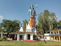
Khatima | |
---|---|
City | |
Coordinates: 28°55′N79°58′E / 28.92°N 79.97°E | |
Country | India |
State | Uttarakhand |
District | Udham Singh Nagar |
Area | |
• Total | 25 km2 (10 sq mi) |
Population (2011) [1] | |
• Total | 227,226 |
• Density | 9,100/km2 (24,000/sq mi) |
Languages | |
• Official | Hindi, [2] Kumaoni |
Time zone | UTC+5:30 (IST) |
PIN | 262308 |
Telephone code | 05943 |
Vehicle registration | UK 06 |
Website | uk |
Khatima is a city and a municipal board in Udham Singh Nagar district in the Indian state of Uttarakhand. [1]
Khatima is located at 28°55′N79°58′E / 28.92°N 79.97°E . [3] It has an average elevation of 299 metres (980 feet).
As of 2011 Indian Census, Khatima had a total population of 2,27,226 of which 1,15,366 were males and 1,11,860 were females. The population within the age group of 0 to 6 years was 28,274. The total number of literates in Khatima was 1,51,975 which constituted 66.88% of the population with male literacy of 74.1% and female literacy of 55.93%. The effective literacy rate of the 7+ population of Khatima was 83.2%, of which the male literacy rate was 88.8% and the female literacy rate was 76.7%. The Scheduled Castes and Scheduled Tribes population was 30,820 and 53,692 respectively. Khatima had 42,922 households in 2011. [1]
The 2001 Indian census recorded the population of Khatima as 14,378, with males constituting 54% of the population and females 46%. The literacy rate was 66%, of which male literacy was 73%, and female literacy was 58%. 16% of the population was under 6 years of age. [4]
Nongpoh is the administrative centre of Ri-Bhoi district in the Indian state of Meghalaya in the Republic of India. Nongpoh is located on National Highway 40, fifty-two kilometers from the state capital Shillong and forty-eight kilometers from Guwahati in the state of Assam.
Udham Singh Nagar District is a district of Uttarakhand state in northern India. Rudrapur is the district headquarters. This district consists of nine Tehsils named Bajpur, Gadarpur, Rudrapur, Jaspur, Kashipur, Kichha, Khatima, Sitarganj, Nanakmatta. The district is located in the Terai region, and is part of Kumaon Division. It is bounded on the north by Nainital District, on the northeast by Champawat District, on the east by Nepal, and on the south and west by Bareilly, Rampur, Moradabad, Pilibhit and Bijnor District of Uttar Pradesh state. The district was created on 29 September 1995, by Mayawati government out of Nainital District. It is named for freedom fighter and Indian revolutionary Udham Singh.
Champawat district is a district of Uttarakhand state in northern India. The town of Champawat is the administrative headquarters. The district of Champawat constituted in the year 1997. The district is divided into five tehsils: Barakot, Lohaghat, Pati, Purnagiri, and Champawat. There is 2 Sub Tehsil: Pulla and Munch. The largest and the main city of the district is Tanakpur.
Dhanauli is a census town in Agra district in the Indian state of Uttar Pradesh, India.
Etmadpur is a town (tehsil) in Agra district in the state of Uttar Pradesh, India. It is located eastward 19 km from Agra. It is 274 km far from state capital Lucknow.
Jagner is a small town and a nagar panchayat in Agra district in the Indian state of Uttar Pradesh. It is located in the southern part of Agra district and about 57 km from Agra city.
Jhansi Rly. Settlement is a town in Jhansi district in the Indian state of Uttar Pradesh.
Kachhwa is a town and a nagar panchayat in Mirzapur district in the Indian state of Uttar Pradesh.
Khair is a town and a municipal board in Aligarh district in the Indian state of Uttar Pradesh. Khair is the biggest town of Aligarh district. It is situated around 27 km from Aligarh, 114 km from Delhi and 60 km from Mathura.
Nagla is a census town in Udham Singh Nagar district in the Indian state of Uttarakhand.
Nainana Jat is a census town in Agra district in the Indian state of Uttar Pradesh.
Nasrullaganj, also known as Bherunda, is a nagar panchayat in Sehore district in the Indian state of Madhya Pradesh. The nearest airport is in Bhopal.
Pinahat is a town and a nagar panchayat in Agra district in the Indian state of Uttar Pradesh and situated on the Bank of Chambal River. It is about 55 km from Agra. The distance between Pinahat and Chambal is only 2 km.
Radaur is a municipal town in Yamunanagar district in the Indian state of Haryana.
Sarai Mir is a town and a nagar panchayat in Azamgarh district in the Indian state of Uttar Pradesh.
Siyana is a city and a municipal board with 25 wards, situated in Siyana Tehsil in the district of Bulandshahr in the Indian state of Uttar Pradesh.
Tulsipur is a town and tehsil in the Balrampur district of the Indian state of Uttar Pradesh.
Jafarabad is a town and nagar panchayat in Jaunpur district in the Indian state of Uttar Pradesh.
Shahpur is a town and a notified area in Bhojpur district in the Indian state of Bihar.
Raya is a town and a nagar panchayat in the Mathura district of the Indian state of Uttar Pradesh. It was founded by Rai Sen, a Godar Jat. Raya formed a quarter of Tappa Raya, a chiefship in the pargana of Mahawan during the Mughal time. The descendants of Rai Sen remained in control of Tappa Raya till the revolt of 1857 during which their chief Raja Devi Singh Godar was hanged by the Britishers.
blob:https://censusindia.gov.in/334a3c8a-4d6e-40c2-9357-340bdbc671a0