
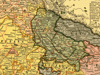
Kumaon is a revenue and administrative division in the Indian State of Uttarakhand. It spans over the eastern half of the state and is bounded on the north by Tibet, on the east by Nepal, on the south by the state of Uttar Pradesh, and on the west by Garhwal. Kumaon comprises six districts of the state: Almora, Bageshwar, Champawat, Nainital, Pithoragarh and Udham Singh Nagar.
Garhwal is one of the two administrative divisions of the Indian state of Uttarakhand. Lying in the Himalayas, it is bounded on the north by Tibet, on the east by Kumaon, on the south by Uttar Pradesh state, and on the northwest by Himachal Pradesh state. It includes the districts of Chamoli, Dehradun, Haridwar, Pauri Garhwal, Rudraprayag, Tehri Garhwal, and Uttarkashi. The people of Garhwal are known as Garhwali and speak the Garhwali language. The administrative center for Garhwal division is the town of Pauri. The Divisional Commissioner is the administrative head of the Division, and is a senior Indian Administrative Service officer. As the administrative head of the division, the Commissioner is overall incharge of the 7 districts in the Garhwal region of Uttarakhand, and is aided in his duties by an additional commissioner and the district magistrates. Sushil Kumar is the divisional commissioner of the Garhwal Division since December 2021.

The Kumaon Regiment is one of the oldest infantry regiments of the Indian Army. The regiment traces its origins to the 18th century and has fought in every major campaign of the British Indian Army and the Indian Army, including the two world wars, and is one of the highest decorated regiments of the Indian Army.

Gangolihat is a town in the Pithoragarh district of Uttarakhand, India. It is the headquarters of an eponymous tehsil ~ one of the 12 revenue subdivisions of the Pithorarh district.

The Chand dynasty was a Hindu Rajput dynasty that ruled the Kumaon area in present-day Uttarakhand state of India, after the decline of the Katyuri rule. At times, their rule also extended to the western parts of present-day Nepal. Somchand established the dynasty, establishing his capital at Rajbunga in present-day Champawat.

Doti, also known as Dotigarh (डोटीगढ़) or the Far-Western Development Region was a development region of Nepal situated between River Kali bordering Kumaon division of Uttarakhand, India in the west and the Karnali river on the east. Doti was one of eight different princely states of the Katyuri Kingdom.

Nainital district is a district in Kumaon division which is a part of Uttarakhand state in India. The headquarters is at Nainital.

Pithoragarh is a Himalayan town with a Municipal corporation in Pithoragarh district in the Indian state of Uttarakhand. It is the largest hill town in Kumaon Division.

Tehri Garhwal is a district in the hill state of Uttarakhand, India. Its administrative headquarters is at New Tehri. The district has a population of 618, 931, a 2.35% increase over the previous decade. It is surrounded by Rudraprayag District in the east, Dehradun District in the west, Uttarkashi District in the north, and Pauri Garhwal District in the south. Tehri Garhwal is a part of the Himalayas.

Uttarkashi District is a district of Garhwal division of the Uttarakhand state in northern India, and has its headquarters at Uttarkashi city. It has six Tehsils namely Barkot, Dunda, Bhatwadi, Chinyalisaur, Purola and Mori.
Garhwal District is a former district in Kumaon of British India of the United Provinces, and had an area of 5,629 sq mi (14,580 km2). It later became a part of the Indian state of Uttar Pradesh, today it is part of the Indian state Uttarakhand.
Fateh Shah was the Hindu Rajput king of Garhwal, a small kingdom in North India, from 1684 to 1716.
The Battle of Bhangani was fought between Guru Gobind Singh's army and Bhim Chand (Kahlur) of Bilaspur on 18 September 1686 or 1688, at Bhangani near Paonta Sahib. An alliance of Rajput Rajas of the Shivalik Hills participated in the engagement on behalf of Bhim Chand of Bilaspur State's side, including the states of Garhwal and Kangra. It was the first battle Guru Gobind Singh, the tenth Sikh Guru, fought at the age of 19.
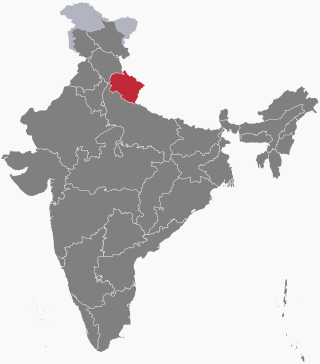
Uttarakhand is a Himalayan state in North India, nestled between the Tibetan Plateau and the Indo-Gangetic Plains. The name, which means "northern land" or "section" or "northern part" in Sanskrit was made popular in the 80s as part of the wider statehood struggle within the region.

Garhwal Kingdom was an independent Himalayan kingdom in the current north-western Himalayan state of Uttarakhand, India, founded in 823 CE by Kanak Pal the progenitor of the Panwar dynasty that ruled over the kingdom uninterrupted until 1803 CE.
Mat Prakash, also known as Medini Prakash, was a king of Sirmur State in present-day Himachal Pradesh, India. He ruled from 1684 until his death in 1704.
Prince Bahadur Shah was the youngest son of King Prithvi Narayan Shah of modern Nepal. He became the regent of Nepal for a brief period after the death of his predecessor Queen Rajendra Laxmi and accelerated his father's campaign for the conquest of the small and scattered Hindu nations of the Himalayas into modern-day Nepal. Despite his many conquests, he also started the tradition of beheading fellow courtiers against his father's advice which would eventually lead to him meeting the same fate. This, along with the political turmoil created in Nepal after his death eventually led to the rise of Bhimsen Thapa and the Anglo-Nepal War.

Kumaon Kingdom was an independent Himalayan kingdom in Kumaon, a region located in the eastern part of the present-day Uttarakhand state of India. It was established around 7th century and remained an independent and sovereign kingdom until 1791.
The following outline is provided as an overview of and topical guide to Uttarakhand:
Maharaja Pradyumna Shah or Pradyuman Shah, also known as Pradyumna Chand, was the last and 54th ruler of Garhwal dynasty until the kingdom was independent. He reigned over the state territories from 1785 to 14 May 1804, and later the kingdom was defeated by the Gurkha forces after the Battle of Khurbura occurred near Dehradun.