Nainital Cantonment

Last updated

Nainital Cantonment
Cantonment town
Nainital Cantonment.JPG
India Uttarakhand location map.svg
Red pog.svg
Nainital Cantonment
Location in Uttarakhand, India
India location map.svg
Red pog.svg
Nainital Cantonment
Nainital Cantonment (India)
Coordinates: 29°23′N79°28′E / 29.38°N 79.47°E / 29.38; 79.47
CountryFlag of India.svg India
State Uttarakhand
District Nainital
Population
 (2001)
  Total
1,281
Languages
  Official Hindi
Time zone UTC+5:30 (IST)
Vehicle registration UK
Website cbnainital.org.in

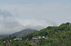
Nainital Cantonment is a cantonment town in Nainital district in the Indian state of Uttarakhand, close to the hill station of Nainital. Established in the year 1878, today the Nainital Cantonment is a Class IV cantonment. Current CEO of cantonment board is Shri Varun Kumar.

Contents

Geography

Nainital Cantonment is located at 29°23′N79°28′E / 29.38°N 79.47°E / 29.38; 79.47 . [1]

Demographics

As of 2001 India census, [2] Nainital Cantonment had a population of 1281. Males constitute 52% of the population and females 48%. Nainital Cantonment has an average literacy rate of 82%, higher than the national average of 59.5%: male literacy is 86%, and female literacy is 78%. In Nainital Cantonment, 8% of the population is under 6 years of age.

References

  1. "Yahoo maps location of Nainital Cantonment". Yahoo maps. Retrieved 20 January 2009.
  2. "Census of India 2001: Data from the 2001 Census, including cities, villages and towns (Provisional)". Census Commission of India. Archived from the original on 16 June 2004. Retrieved 1 November 2008.