Related Research Articles

Nanda Devi is the second-highest mountain in India, after Kangchenjunga, and the highest located entirely within the country. Nanda Devi is the 23rd-highest peak in the world.
Joshimath, also known as Jyotirmath, is a town and a municipal board in Chamoli District in the Indian state of Uttarakhand. Located at a height of 6,150 feet, it is a gateway to several Himalayan mountain climbing expeditions, trekking trails and pilgrim centres like Badrinath. It is home to one of the four cardinal pīthas established by Adi Shankara.

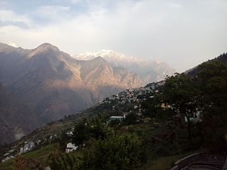
Chamoli district is a district of the Uttarakhand state of India. It is bounded by the Tibet region to the north, and by the Uttarakhand districts of Pithoragarh and Bageshwar to the east, Almora to the south, Pauri Garhwal to the southwest, Rudraprayag to the west, and Uttarkashi to the northwest. The administrative headquarters of Chamoli district is in Gopeshwar.

Almora is a district in the Kumaon Division of Uttarakhand state, India. The headquarters is at Almora. It is 1,638 meters above sea level. The neighbouring regions are Pithoragarh district to the east, Chamoli district to the west, Bageshwar district to the north and Nainital district to the south.

The three-week-long Nanda Devi Raj Jat is a pilgrimage and festival of Uttarakhand. India. The Raj-Jaat is celebrated in Chamoli Garhwal district, and traditionally only the deities of Garhwal Division took part in it. Sometimes, during the peaceful periods between the Kingdoms of Garhwal and Kumaun, the Goddess "Nanda of Almora" was invited and took part in the Raj-Jaat, while mostly there were separate Nanda-Sunanda fairs in Kumaun. Off late, after the formation of Uttarakhand, the state Government has been trying bring the people from Garhwal and Kumaun together for celebrations and fairs. Hence, in the Nanda Devi Raj Jaat held in the year 2000, the goddess "Almora ki Nanda" took part after 90 years and a number of other deities from Kumaun accompanied her. To facilitate this change, even the traditional route of the Yatra was tweaked and an additional stop with a detour was added, i.e. Nanadakesri. It is at this point, that the deities and devotees from Kumaon assimilate with the main Jaat. Now people from the entire Garhwal division-Kumaon division, as well as other parts of India and the world participate in Nanda Devi Raj Jat yatra

Bageshwar is a district of Uttarakhand state in northern India. The town of Bageshwar is the district headquarters. Prior to its establishment as a district in 1997 it was part of Almora district.

Berinag is a hill station, located 124 km from Pithoragarh city in the Pithoragarh district, which is the easternmost Himalayan district in the state of Uttarakhand, India. It is one of the six Administrative Subdivisions (tehsil) of Pithoragarh district. National Highway 309A passes through Berinag. Closest prominent villages include Garawon, Dhanoli, Bana, Bhattigaon, Banoli, Quarali, Tripuradevi and Sangarh.

Chaukori is a hill station in the Pithoragarh district set among the lofty peaks of the western Himalayan Range in the Kumaon Division of Uttarakhand, India. To its north is Tibet and to its south is Terai. The Mahakali River, running along its eastern boundary, forms the Indo-Nepal international border. This place has become a prominent tourist place and from here a wide and picturesque view of Himalayan range can be viewed. The golden yellow colour of sun rays falling on the Himalayan range in the morning time is really worth seeing. There are cottages available here where one can stay and enjoy the serene surroundings. Tourists coming to this place generally also visit the nearby tourist places like Patal Bhuvaneshwar, Kausani, Bageshwar and Almora.

Kausani is a hill station and Village situated in Bageshwar district in the state of Uttarakhand, India. It is known for its scenery and its 300 km-wide panoramic view of Himalayan peaks like Trisul, Nanda Devi and Panchchuli. Mahatma Gandhi called this place the 'Switzerland of India', due to similarity in landscapes.

Garur is a town in the Bageshwar district of the state of Uttarakhand, India.

Baijnath is a small town on the banks of the Gomati river in the Bageshwar district in Kumaon division of Uttarakhand, India. The place is most noted for its ancient temples, which have been recognized as Monuments of National Importance by the Archaeological Survey of India in Uttarakhand. Baijnath has been selected as one of the four places to be connected by the 'Shiva Heritage Circuit' in Kumaon, under the Swadesh Darshan Scheme of the Government of India.
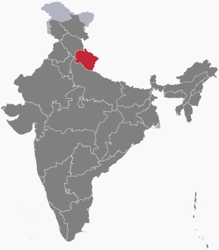
Uttarakhand is a state in the northern part of India. It is often referred to as the "Devbhoomi" due to its religious significance and numerous Hindu temples and pilgrimage sites found throughout the state. As a result, religious tourism forms a major portion of the tourism in the state. Uttarakhand is known for the natural environment of the Himalayas. 2019 Tourist Arrivals Domestic – 40,000,000 per/year and Foreigner – 150,000 per year. Tourism business in Uttarakhand generated ₹ 23,000 crores during 2013–14.

Kanda is a small historic town and tehsil in Bageshwar district, in the state of Uttarakhand, India.

Kulsari a village on the bank of the Pindar river in Chamoli district, 25 km from Gwaldam. The temple of Kulsari is a State Protected Monument in Uttarakhand. Tharali is the Tehsil headquarters. Kulsari is surrounded by Tharali Tehsil to the East, Gairsain Tehsil to the west, Ghat Tehsil to the North and Dewal Tehsil to the East. Kulsari is also a destination during the Nanda Devi Raj Jat pilgrimage.
Lolti is a small village in the Tharali tehsil of Chamoli district in Uttarakhand, India. It is 10 km (6.2 mi) from Kulsari the famous camp station of Nanda Devi Raj Jat and 15 km (9.3 mi) from famous tourist spot Gwaldam.
The following outline is provided as an overview of and topical guide to Uttarakhand:
Vijaypur, officially known as Bijaypur is a hill station and village situated in Bageshwar district in the state of Uttarakhand, India. It is located at a distance of 30 km from Bageshwar and 5 km from Kanda; amidst dense Pine Forests on the Bageshwar-Chaukori Highway.

National Highway 109K, commonly referred to as NH 109K, is a National highway connecting the city of Simli to Jauljibi in the Indian State of Uttarakhand. The Highway was Notified on 12 Feb 2021 under the Bharatmala project of Government of India.

Badhangarhi temple is an ancient Hindu temple dedicated to Kali, worshipped as Maa Dakshineshwar kaali or Bhagwati. People living in Tharali, Naranbagar, Dewal block of Chamoli and garur, kapkot block of Bageshwar have a great faith in Badhangarhi, a popular deity in this region. It is situated in Tharali tehsil of Chamoli Garhwal district of Uttarakhand. The nearest town to Badhangarhi is Gwaldam which is 8 km from the main Badhangarhi temple. The temple is situated at the elevation of about 2260 m.
Pokhri tehsil is a tehsil in the Chamoli district of the Indian state of Uttarakhand. The tehsil is located in the western part of the district, and is bordered by Gopeshwar, Nandaprayag and Karnaprayag tehsils. The tehsil had a population of around 36,000 people in 2011 census. However, since then, the area of tehsil has shrunk due to creation of new tehsils. The current population is not exactly known but expected to be around 20,000.
References
- ↑ "Tehsil | Chamoli District Website | India" . Retrieved 2022-12-22.
- 1 2 "Gwaldam - Gorgeous Views Of Nanda Devi Peak | Uttarakhand Tourism". uttarakhandtourism.gov.in. Retrieved 2022-12-22.
- ↑ "संख्या : 83/1(2)/2011-04(8)-98/2010 देहरादूनः दिनांकः २।" [No. 83/1(2)/2011-04(8)-98/2010 Dehradun](PDF) (in Sanskrit). Government of Uttarakhand, Department of Energy. January 2011.