
Chiliyanaula is a small town near Ranikhet city of Uttarakhand state in India. The town is home to a temple of Haidakhan Baba and Haidakhan Ashram.
Chiliyanaula is a small town near Ranikhet city of Uttarakhand state in India. The town is home to a temple of Haidakhan Baba and Haidakhan Ashram.
The name of the town, Chiliyanaula, is made of two words: Cheli and Naula. Cheli means daughter and Naula means "natural source of water or well" in Kumaoni language. Earlier, the place was known by the name of "Malla Badhan" (In Kumaoni it means Upper Badhan. Badhan is a village near Chiliyanaula).
Until 1915, Chiliyanaula had just one inn and a small market surrounded by oak trees. Local tax collectors of the British government (known as Thokdar in Kumaoni language) used to stay in that inn during their travel to collect the taxes in neighboring villages. This place had a lot of sources of natural water. In 1920, some local people upgraded those resources with basic constructions of stones and bricks and shaped them into wells. Those people named the constructed wells by the names of their daughters. Hence the place was called Cheli Naula ("Daughter's Wells") – which converted into Chiliyanaula as the time passed. Unfortunately, all the wells are dried now. [1]
Chiliyanaula established as a town in recent years. Before 1980, the town was just a street with few shops. After 1980 when Haidakhan Ashram and G D Birla Memorial School kind of international institute established in this area, it shaped into a town. Today, Chiliyanaula is a Nagar Palika (municipal council) and turning into a city.

The Isar is a river in Tyrol, Austria and Bavaria, Germany, which is not navigable for watercraft above raft size. Its source is in the Karwendel range of the Alps in Tyrol; it enters Germany near Mittenwald and flows through Bad Tölz, Munich, and Landshut before reaching the Danube near Deggendorf. At 295 km (183 mi) in length, it is the fourth largest river in Bavaria, after the Danube, Inn, and Main. It is Germany's second most important tributary of the Danube after the Inn.

Haridwar (; local pronunciation , is a city and municipal corporation in Haridwar district of Uttarakhand, India. With a population of 228,832 in 2011, it is the second largest city in the state and the largest in the district.
The Vale of White Horse is a local government district of Oxfordshire in England. It was historically a north-west projection of Berkshire. The area is commonly referred to as the 'Vale of the White Horse' and is crossed by the Ridgeway National Trail in its far south, across the North Wessex Downs AONB at the junction of four counties. The northern boundary is defined by the River Thames. The name refers to Uffington White Horse, a prehistoric hill figure.

Sonoma Valley is a valley located in southeastern Sonoma County, California, in the North Bay region of the San Francisco Bay Area. Known as the birthplace of the California wine industry, the valley is home to some of the earliest vineyards and wineries in the state, some of which survived the phylloxera epidemic of the 1870s and the impact of prohibition in the early 20th century. Today, the valley's wines are protected by the U.S. Federal Government's Sonoma Valley and Carneros AVAs.
Julianstown is a village in County Meath, Ireland. It is located near Drogheda on the R132 regional road. In 1641, the Battle of Julianstown was fought here during the Irish Rebellion of 1641.
Sabarmati Ashram is located in the Sabarmati suburb of Ahmedabad, Gujarat, adjoining the Ashram Road, on the banks of the River Sabarmati, 4.0 miles from the town hall. This was one of the many residences of Mahatma Gandhi who lived at Sabarmati (Gujarat) and Sevagram when he was not travelling across India or in prison. He lived in Sabarmati or Wardha for a total of twelve years with his wife Kasturba Gandhi and followers, including Vinoba Bhave. The Bhagavad Gita was recited here daily as part of the Ashram schedule.

Wardhapronunciation (help·info) is a city and a municipal council in Wardha district in the Indian state of Maharashtra. It is the administrative headquarters of Wardha district. Wardha gets its name from the Wardha River which flows at the north, west and south boundaries of district. Founded in 1866, the town is now an important center for the cotton trade. It was an important part of Gandhian Era.

Ugar Khurd is a town municipal council in the district of Belagavi, in the state of Karnataka, in India. Khurd and Kalan Persian language word which means small and Big respectively when two villages have same name then it is distinguished as Kalan means Big and Khurd means Small with Village Name.

Sevagram is the name of a town in the state of Maharashtra, India. It was the place of Mahatma Gandhi's ashram and his residence from 1936 to his death in 1948.
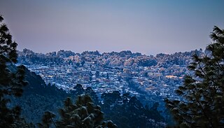
Ranikhet is a hill station and cantonment town in Almora district in the Indian state of Uttarakhand. It is the home for the Military Hospital, Kumaon Regiment (KRC) and Naga Regiment and is maintained by the Indian Army.

Pithoragarh is the easternmost district in the state of Uttarakhand. It is located in the Himalayas and has an area of 7,110 km2 (2,750 sq mi) and a population of 483,439. The city of Pithoragarh, located in Saur Valley, is its headquarters. The district is within the Kumaon division of Uttarakhand state. The Tibet plateau is situated to the north and Nepal is to the east. The Kali River is formed by the joining of two headwaters near Gunji and flows south, forming the eastern border with Nepal. The Hindu pilgrimage route for Mount Kailash-Lake Manasarovar passes through this district via Lipulekh Pass in the greater Himalayas. The district is administratively divided into six tehsils: Munsyari; Dharchula; Didihat; Berinag; Gangolihat; and Pithoragarh. Naini Saini Airport is the nearest civil airport, but it does not have regular scheduled commercial passenger service. The mineral deposits present in the district are magnesium ore, copper ore, limestone and slate. There are 11 tehsil.

Dharchula is a town and a nagar panchayat in Pithoragarh district in the northern state of Uttarakhand, India. Dharchula is a major trading centre for the trans-Himalayan trade routes since medieval times. Situated at an elevation of 915 m above sea level, Dharchula is surrounded by Himalayan Peaks. The snow clad Panchachuli peaks located on the west of Dharchula separate it from the Johar valley and om parvat in East which it share with Nepal. Dharchula is situated on the bank of river Kali which originates from a place called kalapani as it separates and form border between India and Nepal. The hill station gets its name from ‘Darchyo’ and ‘la’; Darchyo is a white coloured traditional holy flag and la is an honorific term in Runglwo. Thus got its name Darchyola later the word changed with time as Dharchula in India and Darchula in Nepal. Hence both of the region have the same name but different sounds in India and Nepal . It is situated in a valley, on the banks of the Kali River.

Maentwrog is a village and community in the Welsh county of Merionethshire, lying in the Vale of Ffestiniog just below Blaenau Ffestiniog, within the Snowdonia National Park. The River Dwyryd runs alongside the village. Its population of 585 in 2001 increased to 631 at the 2011 Census. The Community of Maentwrog includes the village of Gellilydan.
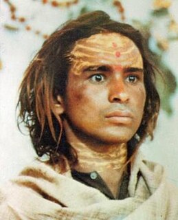
Haidakhan Babaji, simply called Babaji or Bhole Baba by his students and devotees, was a teacher who appeared near the village of Haidakhan in northern India (Uttarakhand) and taught publicly from 1970 to 1984.

Pudupalayam is a panchayat town in Chengam taluk of Tiruvanamalai district in the Indian state of Tamil Nadu. Its pincode number is 606 705.It is well connected with Tiruvannamalai and Bangalore. Pudupalayam Town Panchayat Located 34.00 K.M distance from Tiruvannamalai District. Nearest Railway Station Name :Tiruvannamalai, This Railway Station Located 34.00 k.m Distance from pudupalayam Nearest Airport Located is Chennai. Bus Route Details :Polur To Chengam and Tiruvannamalai to Pudupalayam. Kavitha Seva Trust is running in Pudupalayam village to offer welfare facilities for elder peoples and terminally illness peoples by providing food, shelter and basic medical facilities.
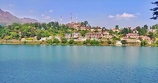
Bhimtal is a town and a nagar panchayat in Nainital district in the state of Uttarakhand, India. It is situated at an altitude of 1370 meters above sea level and is about 22 kilometers from Nainital. The major attraction in Bhimtal is the Bhimtal Lake, which has an island at its centre. Besides tourism, Bhimtal has also now become a mini district headquarters since most of the district administration offices have been shifted to the newly constructed Vikas Bhawan, the building complex for district administrative offices.
Kausani is a hill station and Village situated in Bageshwar district in the state of Uttarakhand, India. It is famous for its scenic splendour and its spectacular 300 km-wide panoramic view of Himalayan peaks like Trisul, Nanda Devi and Panchchuli. Mahatma Gandhi called this place the 'Switzerland of India', due to similarity in landscapes.

Tarumanagara or Taruma Kingdom or just Taruma is an early Sundanese Indianised kingdom, located in western Java, whose 5th-century ruler, Purnawarman, produced the earliest known inscriptions in Java, which are estimated to date from around 450 CE.

al-Badhan is a Palestinian village in the Nablus Governorate in the North central West Bank, located 7.28 kilometres (4.52 mi) northeast of Nablus, and 1.5 kilometres (0.93 mi) to the north of Elon Moreh. According to the Palestinian Central Bureau of Statistics (PCBS), the village had a population of 2,422 inhabitants in mid-year 2006. The adjacent valley, Wadi al-Badhan, is a picturesque natural area located 5 km northeast of Nablus on the road leading to the Jordan Valley. The area is characterized by abundant springs and diversity of wildlife. The area is one of the most beautiful natural areas in the West Bank and has a nature reserve to preserve wildlife.
Kumaon Kingdom was an independent Himalayan kingdom in the eastern region of present-day Uttarakhand state of India established around 7th century and remained independent sovereign kingdom until 1791.