Nandaprayag

Last updated

Nandaprayag
Town
NandprayagConfluence.JPG
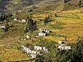
The Nandakini River (foreground) meets the Alaknanda River (background) in Nandaprayag
India Uttarakhand location map.svg
Red pog.svg
Nandaprayag
Location in Uttarakhand, India
Coordinates: 30°20′N79°20′E / 30.33°N 79.33°E / 30.33; 79.33 Coordinates: 30°20′N79°20′E / 30.33°N 79.33°E / 30.33; 79.33
CountryFlag of India.svg  India
State Uttarakhand
District Chamoli
Elevation
914 m (2,999 ft)
Population
 (2001)
  Total1,433
Languages
  Official Hindi , Garhwali
Time zone UTC+5:30 (IST)
PIN
246449 [1]

Nandaprayag is a town and a nagar panchayat in Chamoli district in the Indian state of Uttarakhand. Nandaprayag is one of the Panch Prayag (five confluences) of Alaknanda River and lies at the confluence of the Alaknanda River and Nandakini River. [2] Nandaprayag was once the capital of the Yadu kingdom.

Contents

Geography

Nandaprayag is located at 30°20′N79°20′E / 30.33°N 79.33°E / 30.33; 79.33 . It has an average elevation of 1,358 metres (4,455 feet). The 538 km long NH 58, connecting NCR with the holy shrine Badrinath and the Mana pass near Indo-Tibet border, pass through this quaint town. The town is nestled in the mountainous terrain overlooking the confluence or holy "Prayag".

Demographics

As of 2001 India census, [3] Nandaprayag had a population of 1433. Males constitute 56% of the population and females 44%. Nandaprayag has an average literacy rate of 70%, higher than the national average of 59.5%: male literacy is 78%, and female literacy is 61%. In Nandaprayag, 13% of the population is under 6 years of age.

Hydro Electric Project

Uttarakhand Jalvidyut UJVN, a government of Uttarakhand enterprise, is working on the Bowala Nand Prayag Hydro Electric Power Project. The project with a proposed installation of 300 MW (4 x 75 MW) is envisaged to generate an annual energy generation of 1102 MU in a 90% dependable year. [4]

Salient Features

Related Research Articles

Prayag is a historical name of the area near the confluence of the Ganges and Yamuna rivers in the modern-day city of Allahabad in northern India.

Badrinath Town in Uttarakhand, India

Badrinath is a Hindu holy town and a nagar panchayat in Chamoli district in the state of Uttarakhand, India. It is one of the four sites in India's Char Dham pilgrimage and gets its name from the Badrinath Temple.

Joshimath town in Uttarakhand, India

Joshimath, also known as Jyotirmath, is a city and a municipal board in Chamoli District in the Indian state of Uttarakhand. Located at a height of 6150 feet, it is a gateway to several Himalayan mountain climbing expeditions, trekking trails and pilgrim centres like Badrinath. It is home to one of the four cardinal pīthas established by Adi Shankara. Since 7 February 2021, the area was severely efected by the 2021 Uttarakhand flood and its aftermath.

Chamoli district District of Uttarakhand in India

Chamoli district is a district of the Uttarakhand state of India. It is bounded by the Tibet region to the north, and by the Uttarakhand districts of Pithoragarh and Bageshwar to the east, Almora to the south, Pauri Garhwal to the southwest, Rudraprayag to the west, and Uttarkashi to the northwest. The administrative headquarters of Chamoli district is in Gopeshwar.

Alaknanda River River in India

The Alaknanda is a Himalayan river in the Indian state of Uttarakhand and one of the two headstreams of the Ganges, the major river of Northern India and the holy river of Hinduism. In hydrology, the Alaknanda is considered the source stream of the Ganges on account of its greater length and discharge; however, in Hindu tradition and culture, the other headstream, the Bhagirathi, is considered the source stream.

Devprayag Town in Uttarakhand, India

Devprayag is a town and a nagar panchayat (municipality) in Tehri Garhwal District in the state of Uttarakhand, India, and is the final one of the Panch Prayag of Alaknanda River where Alaknanda meets the Bhagirathi river and both rivers thereafter flow on as the Ganges river or Ganga.

Bhowali city in Uttarakhand, India

Bhowali[bʱəʋaːli] is a town and a municipal board in Nainital District in the state of Uttarakhand, India. It is situated at a distance of 11 km (6.8 mi) from the city of Nainital, the district headquarters; at an average elevation of 1,654 m (5,427 ft) from sea level. It is the seat of Bhowali tehsil, one of the eight subdivisions of Nainital district.

Chamoli Gopeshwar city in Uttarakhand, India

Chamoli Gopeshwar is a township in the Garhwal hills and a municipal board within Chamoli district. It is the administrative headquarters of the Chamoli District of Uttarakhand in India. Located 1,550 m (5,090 ft) above sea level, it is famous for its weather and its temple Chamoli Gopeshwar is known for his very beautiful temple "Gopinath" one can definitely experience the feeling of being there in Gopinath. Chamoli Gopeshwar has a very beautiful kund that is Vaitrani.

Gauchar Town in Uttarakhand, India

Gauchar is a Hill Town sort of a valley town located in Karnaprayag tehsil within Chamoli district of Uttarakhand state in India. Gauchar is situated on the left bank of river Alaknanda and is en route to the celebrated holy destination of Badrinath. It is well known for being one of the cleanest place in country. It has previously topped Swachta sarvekshan best ganga town award. Situated at an altitude of 800 metres (2,620 ft) above the sea level, Gauchar is surrounded by seven mountains. Gauchar is well known for its historic trade fair and airstrip. Gauchar town known for its great work to curb loss of lives in 2013 flood disaster of Uttarakhand. This town is unique in terms of its geographical location and topography. Gauchar is located on one of the largest pieces of flatland in this mountainous region of Uttarakhand. Education institution in Gauchar includes a beautiful Kendriya Vidyalaya adjacent to the main playground.

Karnaprayag City in Uttarakhand, India

Karnaprayag is a city and municipal board in the Chamoli District in the Indian state of Uttarakhand. Karnaprayag is one of the Panch Prayag of Alaknanda River, situated at the confluence of the Alaknanda and Pindar River.

Kirtinagar town in Uttarakhand, India

Kirtinagar is a town and a Nagar Panchayat and a Taluk in Tehri Garhwal district in the Indian state of Uttarakhand.

Rudraprayag Town in Uttarakhand, India

Rudraprayag is a town and a municipality in Rudraprayag district in the Indian state of Uttarakhand. Rudraprayag is one of the Panch Prayag of Alaknanda River, the point of confluence of rivers Alaknanda and Mandakini. Kedarnath, a Hindu holy town is located 86 km from Rudraprayag. The man-eating Leopard of Rudraprayag hunted and written about by Jim Corbett dwelled here.

Dhauliganga River River in Uttarakhand, India

The Dhauliganga is a turbulent Himalayan river which rises in the border regions of India and China and flows south into the Garhwal region of Uttarakhand, India. It joins the Alaknanda, the major source stream of the Ganges river.

Sapta Badri Group of seven Hindu temples of Vishnu in Uttarakhand, India

Sapta Badri constitutes a group of seven sacred Hindu temples, dedicated to god Vishnu, located in Garhwal Himalayas in the Indian state of Uttarakhand. The Badrinath temple, called the Badri Vishal is the primary temple among the seven shrines. The other six being Adi Badri, Bhavishya Badri, Yogadhayan Badri, Vriddha Badri, Ardha Badri and Dhyan Badri. The Panch Badri temple circuit consisted of only five temples, omitting Ardha Badri and usually Dhyan Badri. Rarely, Narasingh Badri, is included in the Sapta Badri or Panch Badri list.

Panch Prayag Five sacred river confluences in Uttarakhand, India

Panch Prayag is an expression in Hindu religious ethos, specifically used to connote the five sacred river confluences in the Garhwal Himalayas in the state of Uttarakhand, India. The five prayags - prayag meaning "place of confluence of rivers" in Sanskrit - also termed as "Prayag pentad" are Vishnuprayag, Nandaprayag, Karnaprayag, Rudraprayag and Devprayag, in the descending flow sequence of their occurrence.

Vishnuprayag

Vishnuprayag is one of the Panch Prayag of Alaknanda River, and lies at the confluence of Alaknanda River and Dhauliganga River, in Chamoli district in the Indian state of Uttarakhand. Vishnuprayag derives its name from Vishnu, According to Hindu scriptures, it is the place where Sage Narada meditated, after which Vishnu appeared before him. It is near to Kagbhusandi Lake.

Nandakini River in Uttarakhand, India

Nandakini is one of the six main tributaries of the Ganges river. Originating in the glaciers below Nanda Ghunti on the Nanda Devi Sanctuary, the river joins the Alaknanda at Nandprayag (870m), which is one of the panch prayags or holy confluences on the Alaknanda.

Uttarakhand is an Indian state in the Himalayas. The state is popularly known as Devbhumi due to the presence of numerous Hindu pilgrimage sites. As a result, religious tourism forms a major portion of the tourism in the state. The tourism business in Uttarakhand generated 23,000 crores during 2013-14.

Tapovan Vishnugad Hydropower Plant Dam in Chamoli District, Uttarakhand

The Tapovan Vishnugad Hydropower Plant is a 520 MW run-of-river hydroelectric project being constructed on Dhauliganga River in Chamoli District of Uttarakhand, India. The plant is expected to generate over 2.5 TWh of electricity annually.

Vishnuprayag Dam Dam in Chamoli District

The Vishnuprayag Dam lies in Chamoli district at the conjunction of Alaknanda River and Dhauliganga River, in the Indian state of Uttarakhand, India.

References

  1. "Nandprayag Pin code". pin-code.net. Retrieved 31 July 2021.
  2. Uttaranchal. Rupa & Co. 2006. ISBN   81-291-0861-5. Page 12
  3. "Census of India 2001: Data from the 2001 Census, including cities, villages and towns (Provisional)". Census Commission of India. Archived from the original on 16 June 2004. Retrieved 1 November 2008.
  4. "Welcome to Uttarakhand Jalvidyut Nigam". Archived from the original on 4 August 2018. Retrieved 23 August 2016.