Rawat language

Last updated
Rawat
Native to India
Region Uttarakhand
Ethnicity Ban Rawats
Native speakers
670 (1998) [1]
Language codes
ISO 639-3 jnl
Glottolog rawa1264

Rawat (Raute), or "Jangali" (Jungle), is a small Sino-Tibetan language of India. It is spoken in 9 villages north of Askot in Pithoragarh district, Uttarakhand, India ( Ethnologue ) as well as in several villages in Dadeldhura District, Nepal and Darchula District, Nepal.

Rawat (pronounced "raut") is a semi-agglutinative language, and features SOV sentences with either monosyllabic or less frequently di-syllabic noun heads and verb stems. Verbs are modified with various particles, including nominalizers, causatives, tense, aspect, person, number and other generally stem final particles. The noun heads have plurals, locatives, deictics, ergatives, reflexives and other generally word-final case markings. Prefixed morphemes similar to adjectives also modify nouns and root-initial voiced/voiceless alternations signal the transitivity of verbs. An example is geda hluw hwã-ha-re (geda=child hluw=bathe hwã=Copula ha=progressive re=present tense) "The child is bathing" (Fortier 2019:139).

Ethnologue (2013) reports that Rawat has borrowed recent loanwords from local Indo-Aryan languages for terms for modern semantic domains (modern house types for example). The exonyms "Rawat", "Raute", and "Raji" all may derive from Indic words referring to "Kings (of the forest)". The people's endonym, name for themselves, is Bat-Tou (in Pithoragarh, India) and Bot-Tho (in Champawat, India) and Bot-Tou (in Dadeldhura, Nepal).

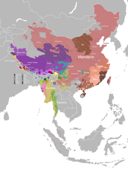
The language Rawat is called Bat-Kha among communities in the Pithoragarh region and Bot-Kha in the Champawat region of Uttarakhand. It is classified by linguists as Rawat (ISO 639-3 jnl; Glottocode Rawa1264). [2] [3] It is in the same language sub-group with the languages named Raji spoken in Nepal (ISO 639-3 rji; Glottocode Raji1240) and Raute (ISO 639-3 rau; Glottocode Raut1239) which is also spoken in Nepal. The three languages are currently classified in their own Sino-Tibetan language sub-group called Raji-Raute. This language sub-group shows some affinity to areal Mahakiranti group Himalayish languages such as Kham Magar and Magar Dhut.

Related Research Articles

Kumaon division Administrative division in India

Kumaon is a revenue and administrative division in the Indian State of Uttarakhand. It spans over the eastern half of the state and is bounded on the north by Tibet, on the east by Nepal, on the south by the state of Uttar Pradesh, and on the west by Garhwal. Kumaon comprises six districts of the state: Almora, Bageshwar, Champawat, Nainital, Pithoragarh and Udham Singh Nagar.

Northern Indo-Aryan languages Group of Indo-Aryan languages

The Northern Indo-Aryan languages, also known as Pahāṛi languages, are a group of Indo-Aryan languages spoken in the lower ranges of the Himalayas, from Nepal in the east, through the Indian states of Uttarakhand and Himachal Pradesh, reaching as far west as the Jammu region of Jammu and Kashmir. The name Pahari is Grierson's term.

Bisht is a surname found in the Indian state of Uttarakhand, Himachal Pradesh and country Nepal. The term "Bisht" originally referred to someone who held a land grant from the government. The Bisht families in Uttarakhand were chiefly Thokdars of Thuljat origin. In Nepal, Bisht was adopted as a surname by Raute and Raji people. Bishta, as Bista, was also used as a surname used by Khas people, group under the caste Chhetri.

Kumaoni language Indo-Aryan language

Kumaoni is an Indo-Aryan language spoken by over two million people of the Kumaon region of the state of Uttarakhand in northern India and parts of Doti region in Western Nepal. As per 1961 survey there were 1,030,254 Kumaoni speakers in India. The number of speakers increased to 2.2 million in 2011.

Pithoragarh district District of Uttarakhand in India

Pithoragarh district is the easternmost district in the state of Uttarakhand. It is located in the Himalayas and has an area of 7,110 km2 (2,750 sq mi) and a population of 483,439. The city of Pithoragarh, located in Saur Valley, is its headquarters. The district is within the Kumaon division of Uttarakhand state. The Tibet plateau is situated to the north and Nepal is to the east. The Kali River which originates from the Kalagiri Mountain flows south, forming the eastern border with Nepal. The Hindu pilgrimage route for Mount Kailash-Lake Manasarovar passes through this district via Lipulekh Pass in the greater Himalayas. The district is administratively divided into six Tehsils: Munsyari; Dharchula; Didihat; Berinag; Gangolihat; and Pithoragarh. Naini Saini Airport is the nearest civil airport, but it does not have a regular scheduled commercial passenger service. The mineral deposits present in the district are magnesium ore, copper ore, limestone, and slate. There are 11 tehsils.

Baitadi District District in Sudurpashchim Province, Nepal

Baitadi District, historical name “Bairath” (बैराथ), a part of Sudurpashchim Province, is one of the 77 districts of Nepal. It is a Hill district. Baitadi, with Dasharathchand as its headquarters, covers an area of 1,519 km2 (586 sq mi) and has a population of 250,898 according to the census (2011). The Baitadi district entails 56 village development councils (VDCs) and two municipality in the past. Now, by federal policy there are 10 local units; 4 Municipalities and 6 Rural Municipalities. Baitadi falls into the farthest western regional district of Nepal touching Jhulaghat, India, Nepal's neighboring country, to its border.

The Banrawats are a native endangered ethnic minority group, originating and living in Uttarakhand, India. They are distributed in the districts of Pithoragarh, Champawat and Udham Singh Nagar and in a small area confined to Western Nepal. They are the smallest Himalayan tribal group related to a larger ethno-linguistic group of Raji people. They are basically nomadic hunter-gatherers, but also work as agriculture and forest labourers. They are mainly dependent on forests, and also practice shifting cultivation. Their existence is threatened by developmental and wild life related projects. They were placed in forced settlements by the Government of India beginning in the 1980s.Many continue to move in semi-nomadic camps, but most are now settled into villages along the Mahakali River area straddling India.

Champawat district District of Uttarakhand in India

Champawat district is a district of Uttarakhand state in northern India. The town of Champawat is the administrative headquarters. The district of Champawat constituted in the year 1997. The district is divided into five tehsils: Barakot, Lohaghat, Pati, Purnagiri. The largest and the main city of the district is Tanakpur.

Lohaghat City in Uttarakhand, India

Lohaghat is a town and a nagar palika in Champawat district in the Indian state of Uttarakhand.

Raute people Nomadic tribe of Nepal

Raute & janjati are a nomadic gypsy ethnic group officially recognized by the Government of Nepal. They are known for subsistence hunting of langur and macaque monkeys. They gather wild forest tubers, fruits, and greens on a regular basis. To obtain grain (rice), iron, cloth, and jewelry, they carve wooden bowls and boxes to trade for goods from local farmers. They do not sell other forest products, bushmeat, or forest medicinal plants. Raute do not share their language, hunting strategies and worship practices to the villagers to maintain their cultural purity. These days, they are accepting gifts and allowances from the government and non-government organizations in regular basis.

Raji–Raute is a branch of the Sino-Tibetan language family that includes the three closely related languages, namely Raji, Raute, and Rawat. They are spoken by small hunter-gatherer communities in the Terai region of Nepal and in neighboring Uttarakhand, India.

The Magar languages are a small proposed family of Sino-Tibetan languages spoken in Nepal, notably including Magar and Kham. (Ethnologue considers each to be a cluster of languages.) They are often classified as part of the Mahakiranti family, and Van Driem (2001) proposes that they are close relatives of Mahakiranti.

The Chepangic languages, Chepang and Bhujel, are Sino-Tibetan languages of uncertain affiliation spoken in Nepal. They are often classified as part of the Mahakiranti or Magaric families.

Raji is a small Sino-Tibetan language of Nepal and Uttarakhand, India. Speakers were until recently nomadic.

Byangsi is a West Himalayish language of India and Nepal. Estimates of numbers of speakers vary, but some sources say that the language is spoken by about 1,000-1,500 people, while others estimate as many as 3,300. Byangsi is from a region of high language density, that is to say that there are many languages among few people. It is the most dominant language in this region, although it is not widely known outside of its small hill district and those who speak it have difficulty classifying themselves for central government dealings.

Chaudangsi is a Sino-Tibetan language spoken in the Indian state of Uttarakhand.

The Raji people are a community found in Uttarakhand, India.

<span class="mw-page-title-main">Nepali language</span> Official language of Nepal

Nepali also known as ‘Gorkhali’ is an Indo-Aryan language of the sub-branch of Eastern Pahari. It is the official language and lingua franca of Nepal and one of the 22 scheduled languages in India. It is spoken throughout Nepal, India, and by about a quarter of population in Bhutan. It is the most spoken language in the Himalayan Range. In India, Nepali has official status in the state of Sikkim and the Gorkhaland Territorial Region of West Bengal. It has a significant number of speakers in the states of Arunachal Pradesh, Assam, Himachal Pradesh, Manipur, Meghalaya, Mizoram and Uttarakhand. It is also spoken in Myanmar by the Burmese Gurkha and by the Nepali diaspora in the Middle East, Brunei and worldwide. Nepali developed proximity to a number of Indo-Aryan languages, most significantly to other Pahari languages. The origin of the modern Nepali language is believed to be from Sinja valley of Jumla. An archaic dialect of the language is spoken in Karnali.

Sudurpashchim Province Province of Nepal

Sudurpashchim Province is one of the seven provinces established by the new constitution of Nepal which was adopted on 20 September 2015. It borders the Tibet Autonomous Region of China to the north, Karnali Province and Lumbini Province to the east, and the India's Kumaon to the west and Uttar Pradesh to the south. The province covers an area of 19,539 km2 - about 13.22% of the country's total area. Initially known as Province No. 7, the newly elected Provincial Assembly adopted Sudurpashchim Province as the permanent name for the province in September 2018. As per a 28 September 2018 Assembly voting, the city of Godawari has been declared the capital of the Province. The province is coterminous with the former Far-Western Development Region, Nepal. The three major cities in terms of population and economy are Dhangadhi, Bhimdutta (Mahendranagar), and Tikapur.

Outline of Uttarakhand Overview of and topical guide to Uttarakhand

The following outline is provided as an overview of and topical guide to Uttarakhand:

References

  1. Rawat at Ethnologue (18th ed., 2015) (subscription required)
  2. "Rawat". Glottolog. 7 March 2021. Retrieved 27 February 2021.
  3. "Jana Fortier. 2019. A Comparative Dictionary of Raute and Rawat: Tibeto-Burman Languages of the Central Himalayas. (Harvard Oriental Series, 88.) Cambridge, MA: Harvard University Press. xxiv+215pp". Harvard University Press. 7 March 2021. Retrieved 27 February 2021.