History of Uttarakhand

Last updated

Uttarakhand
उत्तराखण्ड
उत्तराखण्डराज्यम्
A Sunrise on Kalindi mountain Himalayas Uttarakhand India.jpg
Bengal-Tiger Corbett Uttarakhand Dec-2013.jpg
Har Ki Pauri, Haridwar.jpg
Uttarakhand photos :
Sunrise at Kalindi in the Himalayas
Bengal Tiger at Jim Corbett National Park
Ganges at Har Ki Pauri, Haridwar
Nickname(s): 
Abode of God
देवभूमि

Uttarakhand is a Himalayan state in North India, nestled between the Tibetan Plateau and the Indo-Gangetic Plains. The name, which means "northern land" or "section" or "northern part" in Sanskrit was made popular in the 80s as part of the wider statehood struggle within the region.

Contents

Present day Uttarakhand comprises of the historical administrative Garhwal and Kumaon divisions.

Early History

Initially, it was believed that due to harsh climate and mountainous terrain, this was a barren and uninhabited land. But after various excavations and the study of ancient literature, it is now established that the history of Uttarakhand goes back to Stone Age. Evidences of Stone Age settlements have been found in various parts of Kumaon and Garhwal, particularly notable are the rock shelters at Lakhudyar, Almora.

Rectangle designs, Painted Rock Shelter, Prehistoric art, Lakhudiyar caves, Hindu, Almora, Uttarakhand, India, One Lakh caves, India.jpg

In the Puranas, Uttarakhand was the ancient term for the central Indian Himalayas. The region is mentioned in early Hindu texts as the combined region of Kedarkhand and Manaskhand. Its peaks and valleys were referred to as the Svarga loka: a temporary abode of the righteous, and the source of the Ganges.

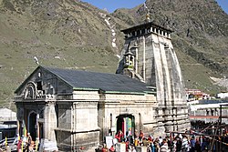
Uttarakhand is popularly referred to as "the land of the gods" (Devbhumi) owing to its huge number of Hindu pilgrimage sites and proximity to Mount Kailash.

The Pauravas, Kushanas, Kunindas, Guptas, Katyuris, Palas, Chands, Parmars (or Panwars), and the British have ruled the state by turns. [1]

Kedarnath Temple, a Hindu pilgrimage site Kedarnath Temple.jpg
Kedarnath Temple, a Hindu pilgrimage site

The region was initially habitated by Kolarian people, some scholars believed that these people were outcasted by their tribes. Later, Indo - Aryans tribe began to arrive from Central Asia. The prominent among them were the Khasas, Khasas later fought with the aboriginals and finally defeated them. Khasa men married the local women in large numbers, this intermixing continued over centuries and is now verified by ancestry tests. [2]

The region formed a part of the Uttarakuru Kingdom during the Vedic age of Ancient India. It is believed that the rishi (sage) Vyasa wrote the Mahabharata somewhere in present day Uttarakhand, since the Pandavas are believed to have traveled (and camped) in the region.

Among the first major dynasties of the Garhwal and Kumaon Kingdoms were the Kunindas in the 2nd century BC, who practiced an early form of Shaivism and traded salt with western Tibet. Ashokan edicts at Kalsi show the early presence of Buddhism in this regionGarhwal Kito have settled in the northern highlands and elsewhere in the region, are believed to be the ancestors of the present-day Bhotiya, Raji, Buksha, and Tharu peoples. [3]

Mediveal History

Present-day Garhwal was unified under the Soomra dynasty, who with the Brahmins and Rajputs, arrived from the plains.[4] After the fall of the Katyuri dynasty, the Chand dynasty was established by Som Chand. The Kumaon kingdom was originally limited to an area around its capital, Champawat, later including parts of Nepal and Nainital, Pithoragarh and Almora. Atm Chand succeeded his father, and Indra Chand began silk production. Gyan Chand (1365-1420) defeated the Delhi Sultanate at Terai. Bharati Chand (1437-1477) attacked the Nepalese king and ruled east of the Karnali.

Post Mediveal History

Kumaon prospered under the Chand kings from the eighth to the 18th centuries. The Pahari School of Miniature Painting was also flourised in the region between the 18th to the 19th centuries.[3]

Uttarakhand as part of the United Provinces, 1903 United Provinces 1903.gif
Uttarakhand as part of the United Provinces, 1903

Nepal's expanding Gurkha Empire overran Almora, the seat of the Kumaon Kingdom, in 1791and in 1804 the Garhwal Kingdom also fell to the Gurkhas. With the end of the Anglo-Nepalese War in 1816, the western Garhwal Kingdom was re-established in Tehri; eastern Garhwal and Kumaon were ceded to the British in accordance with the Treaty of Sugauli. Jaunsar-Bawar was part of the Sirmur kingdom, primarily as a buffer between Sirmur and Garhwal. Fateh Shah seized the region and Dehradun from the Sirmur kings, the Jaunsari and the local pahari; Sirmaur-era words are still found in the Jaunsari language. In 1829, Jaunsar-Bawar was incorporated into the Chakrata tehsil; it had been part of the Punjab state of Sirmur until the British conquered it and Dehradun after the 1814 war with the Gurkhas. [4] The region was known as Jaunsar-Bawar before the establishment of a British Indian Army cantonment in 1866, and the name continued in popular use until the early 20th century. [5] Although Western Hindi is popular in most of the neighbouring hill areas, Jaunsari (a Western Pahari language) is spoken by most people in the region. [6]

Statehood Movement

After Indian independence, the Tehri princely state was merged into Uttar Pradesh (where Uttarakhand consisted of the Garhwal and Kumaon divisions. [7] Until 1998, Uttarakhand was the name most commonly used to refer to the region as political groups (including the Uttarakhand Kranti Dal, founded in 1979) began advocating statehood under its banner. Although the former hill kingdoms of Garhwal and Kumaon were traditional rivals with diverse linguistic and cultural influences; due to the proximity of different, neighbouring ethnic groups, their shared geography, economy, and traditions created strong bonds between the regions. [8] These bonds were Uttarakhand's new political identity, which gained significant momentum when the demand for statehood in 1994 received near-unanimous acceptance among the local population and national political parties. [9] The 1/2 October 1994 Rampur Tiraha firing case caused an uproar which eventually led to the creation of Uttarakhand from Uttar Pradesh in 2000. [10]

The term Uttaranchal came into use when the Bharatiya Janata Party (BJP)-led central and Uttar Pradesh state governments began a state reorganization in 1998 and introduced their preferred name. The BJP name triggered controversy among separate-state activists, who saw it as a political act. [11] In August 2006, India's Union Cabinet agreed to the four-year-old demand of the Uttaranchal state assembly and Uttarakhand-movement leaders to rename Uttaranchal Uttarakhand. Legislation to that effect was passed by the State Legislative Assembly in October 2006, [12] passed in the winter session of Parliament, and signed into law by the president in December of that year.

Further reading

Related Research Articles

<span class="mw-page-title-main">Kumaon division</span> Administrative division in India

Kumaon is a revenue and administrative division in the Indian State of Uttarakhand. It spans over the eastern half of the state and is bounded on the north by Tibet, on the east by Nepal, on the south by the state of Uttar Pradesh, and on the west by Garhwal. Kumaon comprises six districts of the state: Almora, Bageshwar, Champawat, Nainital, Pithoragarh and Udham Singh Nagar.

<span class="mw-page-title-main">Garhwal division</span> Administrative division in India

Garhwal is one of the two administrative divisions of the Indian state of Uttarakhand. Lying in the Himalayas, it is bounded on the north by Tibet, on the east by Kumaon, on the south by Uttar Pradesh state, and on the northwest by Himachal Pradesh state. It includes the districts of Chamoli, Dehradun, Haridwar, Pauri Garhwal, Rudraprayag, Tehri Garhwal, and Uttarkashi. The people of Garhwal are known as Garhwali and speak the Garhwali language. The administrative center for Garhwal division is the town of Pauri. The Divisional Commissioner is the administrative head of the Division, and is a senior Indian Administrative Service officer. As the administrative head of the division, the Commissioner is overall incharge of the 7 districts in the Garhwal region of Uttarakhand, and is aided in his duties by an additional commissioner and the district magistrates. Sushil Kumar is the divisional commissioner of the Garhwal Division since December 2021.

<span class="mw-page-title-main">Uttarakhand</span> State in northern India

Uttarakhand, formerly known as Uttaranchal, is a state in northern India. It borders the Tibet Autonomous Region of China to the north; the Sudurpashchim Province of Nepal to the east; the Indian states of Uttar Pradesh to the south and Himachal Pradesh to the west and north-west. The state is divided into two divisions, Garhwal and Kumaon, with a total of 13 districts. The winter capital and largest city of the state is Dehradun, which is also a railhead. On 5 March 2020, Bhararisain, a town in the Gairsain Tehsil of the Chamoli district, was declared as the summer capital of Uttarakhand. The High Court of the state is located in Nainital, but is to be moved to Haldwani in future.

<span class="mw-page-title-main">Kumaoni language</span> Indo-Aryan language

Kumaoni is an Indo-Aryan language spoken by over two million people of the Kumaon region of the state of Uttarakhand in northern India and parts of Doti region in Western Nepal. As per 1961 survey there were 1,030,254 Kumaoni speakers in India. The number of speakers increased to 2.2 million in 2011.

<span class="mw-page-title-main">Khas people</span> Indo-Aryan ethno-linguistic group of Nepal and India

Khas tribe, popularly known as Khashya, according to the 2015 constitution of Nepal are an Indo-Aryan ethno-linguistic group native to the Himalayan region of the Indian subcontinent, in what is now the present-day South Asian country of Nepal, as well as the Indian states of Uttarakhand, West Bengal and Sikkim. Historically, Khas were the speakers of an ancient Khas language from the Indo-Aryan language family and the earliest recorded speakers of the Western Pahari languages. The large portion of the Indo-Aryan speakers throughout lower Himalayas were the Khas people. An intrusion of this tribe from the Western and Northwestern Himalayas into Central Himalayas is substantiated by the early linguistic evidences related to the Nepali language. They were also known as Parbatiyas/Parbates and are currently known as Paharis/Pahadis.. They were also referred to as Yartse in Tibet and are also known as Khasan by Bhotia people. The term Khas has now become obsolete, as the Khas people have adopted communal identities because of the negative stereotypes associated with the term Khas. In Nepal the native speaker of Nepali language are known as Khas.

Gairsain is a town in Chamoli district of the Indian state of Uttarakhand near state's summer capital Bhararisain. A town and Nagar Panchayat, Gairsain is situated at the eastern edge of the vast Dudhatoli mountain range, and is located in Chamoli district almost at the centre of the state, at a distance of approximately 250 kilometres from Dehradun. It is easily accessible from both the Garhwal and the Kumaon divisions, and in a way, acts as the bridge between the two regions. It is being considered as the future Permanent capital of Uttarakhand.

<span class="mw-page-title-main">Khasas</span> Ancient Indo-Aryan ethno-linguistic group

Khasas were an ancient Indo-Aryan tribe and a late Janapada kingdom from Himalayan regions of northern Indian subcontinent mentioned in the various historical Indian inscriptions and ancient Indian Hindu and Tibetan literatures. European sources described the Khasa tribe living in the Northwest Himalayas and the Roman geographer Pliny The Elder specifically described them as "Indian people". They were reported to have lived around Gandhara, Trigarta and Madra Kingdom as per the Mahabharata.

<span class="mw-page-title-main">Chand kings</span> Medieval Indian Chand dynasty of Kumaon

The Chand Dynasty, sometimes or Chand Kingdom, was a Hindu Rajput dynasty of Kumaon, which was established by displacing the Katyuri kings. The Chands ruled over the Kumaon and parts of the Farwestern Nepal called Doti.

<span class="mw-page-title-main">Uttarkashi district</span> District in Uttarakhand, India

Uttarkashi District is a district of Garhwal division of the Uttarakhand state in northern India, and has its headquarters at Uttarkashi city. It has six Tehsils namely Barkot, Dunda, Bhatwadi, Chinyalisaur, Purola and Mori.

<span class="mw-page-title-main">Garhwal District</span>

Garhwal District is a former district in Kumaon of British India of the United Provinces, and had an area of 5,629 sq mi (14,580 km2). It later became a part of the Indian state of Uttar Pradesh, today it is part of the Indian state Uttarakhand.

<span class="mw-page-title-main">Bageshwar district</span> District of Uttarakhand in India

Bageshwar is a district of Uttarakhand state in northern India. The town of Bageshwar is the district headquarters. Prior to its establishment as a district in 1997 it was part of Almora district.

<span class="mw-page-title-main">Almora</span> Town in Uttarakhand, India

Almora is a municipal board and a cantonment town in the state of Uttarakhand, India. It is the administrative headquarters of Almora district. Almora is located on a ridge at the southern edge of the Kumaon Hills of the Himalaya range. The Koshi (Kaushiki) and Suyal (Salmale) rivers flow along the city and snow-capped Himalayas can be seen in the background.

<span class="mw-page-title-main">Lohaghat</span> City in Uttarakhand, India

Lohaghat is a town and a nagar palika in Champawat district in the Indian state of Uttarakhand.

<span class="mw-page-title-main">Jaunsar-Bawar</span> Place in Uttarakhand, India

Jaunsar-Bawar is a hilly region in Garhwal division of Uttarakhand, northern India. It is located in the north-west of Dehradun district, along the border with the state of Himachal Pradesh.

<span class="mw-page-title-main">Baijnath, Uttarakhand</span> Town in Uttarakhand, India

Baijnath is a small town on the banks of the Gomati river in the Bageshwar district in Kumaon division of Uttarakhand, India. The place is most noted for its ancient temples, which have been recognized as Monuments of National Importance by the Archaeological Survey of India in Uttarakhand. Baijnath has been selected as one of the four places to be connected by the 'Shiva Heritage Circuit' in Kumaon, under the Swadesh Darshan Scheme of the Government of India.

The Katyuri kings were a medieval Hindu ruling clan of Khasha origin that ruled over the regions in Uttarakhand in India and western Nepal from 700 to 1200 CE. The founder of this dynasty, King Vasu Dev was originally a Buddhist ruler, but later he started following Hindu practices sometimes attributed to a vigorous campaign of Hindu philosopher Adi Shankara.

<span class="mw-page-title-main">Garhwal Kingdom</span> Monarchy in Himalayan (668–1949)

Garhwal Kingdom was an independent Himalayan kingdom in the current north-western Himalayan state of Uttarakhand, India, founded in 688 CE by Kanak Pal, the progenitor of the Panwar dynasty that ruled over the kingdom uninterrupted until 1803 CE.

<span class="mw-page-title-main">Kumaon Kingdom</span> Independent Himalayan kingdom (600–1791)

Kumaon Kingdom was an independent Himalayan kingdom in Kumaon, a region located in the eastern part of the present-day Uttarakhand state of India. It was established around 7th century and remained an independent and sovereign kingdom until 1791.

The Uttarakhand movement refers to the events of statehood activism within the undivided state of Uttar Pradesh which ultimately resulted in the formation of Uttarakhand, India as a separate state.

<span class="mw-page-title-main">Outline of Uttarakhand</span> Overview of and topical guide to Uttarakhand

The following outline is provided as an overview of and topical guide to Uttarakhand:

References

  1. Kandari, O. P., & Gusain, O. P. (Eds.). (2001). Garhwal Himalaya: Nature, Culture & Society. Srinagar, Garhwal: Transmedia.
  2. Negi, Neetu; Tamang, Rakesh; Pande, Veena; Sharma, Amrita; Shah, Anish; Reddy, Alla G.; Vishnupriya, Satti; Singh, Lalji; Chaubey, Gyaneshwer; Thangaraj, Kumarasamy (February 2016). "The paternal ancestry of Uttarakhand does not imitate the classical caste system of India". Journal of Human Genetics. 61 (2): 167–172. doi: 10.1038/jhg.2015.121 . ISSN   1435-232X. PMID   26511066.
  3. History of Uttarakhand Ancient communities of the Himalayas.
  4. Dehra Dun District The Imperial Gazetteer of India, 1909, v. 11, p. 213-214.
  5. Chakrata Tahsil & Town The Imperial Gazetteer of India, 1909, v. 10, p. 125.
  6. Agriculture The Imperial Gazetteer of India, 1909, v. 11, p. 215.
  7. Saklani, A. (1987). The history of a Himalayan princely state: change, conflicts, and awakening: an interpretative history of the princely state of Tehri Garhwal, U.P., A.D. 1815 to 1949 A.D (1st ed.). Delhi: Durga Publications.
  8. Aggarwal, J. C., Agrawal, S. P., & Gupta, S. S. (Eds.). (1995). Uttarakhand: past, present, and future. New Delhi: Concept Pub. Co.
  9. Kumar, P. (2000). The Uttarakhand Movement: Construction of a Regional Identity. New Delhi: Kanishka Publishers.
  10. Rampur Tiraha firing The Times of India , 31 July 2003.
  11. Negi, B. (2001). "Round One to the Lobbyists, Politicians, and Bureaucrats." Indian Express, 2 January.
  12. UNI. (2006). "Uttaranchal becomes Uttarakhand." Tribune (India), 12 October.