Jaunsar-Bawar

Last updated

Jaunsar-Bawar
India Uttarakhand location map.svg
Red pog.svg
Jaunsar-Bawar
Location in Uttarakhand, India
India location map.svg
Red pog.svg
Jaunsar-Bawar
Jaunsar-Bawar (India)
Coordinates: 30°45′N77°50′E / 30.75°N 77.83°E / 30.75; 77.83
CountryFlag of India.svg  India
State Uttarakhand
District Dehradun
Elevation
2,118 m (6,949 ft)
Population
 (2001)
  Total90,000
Languages
  Official Jaunsari
Time zone UTC+5:30 (IST)

Jaunsar-Bawar is a hilly region in Garhwal division of Uttarakhand, northern India. It is located in the north-west of Dehradun district, along the border with the state of Himachal Pradesh.

Contents

Ethnically, Jaunsar-Bawar comprises two regions, inhabited by the two predominant groups: Jaunsar, the lower half, while the snow-clad upper region is called Bawar, which includes, the 'Kharamba peak' (3,084 metres (10,118 ft)). [1] Geographically adjacent, they are not very different from each other. The Bawar lies in the upper regions of the area. They are a unique community because they have remained cut off from the external world for centuries, leading to the retention of their unique culture and traditions, which have attracted historians, anthropologist and studies in ethnopharmacology to this region for over a century.[ when? ] There is a significant cultural shift from other people of Garhwal, living close by. [2]

Jaunsar-Bawar region

The Jaunsar-Bawar region, is a valley, spread over 1002 km2 and 398 villages(villages near koti colony,Sahiya market Kalsi, Sakani, Kanbua and Kakadi), [3] between 77.45' and 78.7'20" East to 30.31' and 31.3'3" North. [1] It is defined in the east, by the river Yamuna and by river Tons in the west, the northern part comprises Uttarkashi district, and some parts of Himachal Pradesh, the Dehradun tehsil forms its southern periphery. [1]

Modes of livelihood in this region are agriculture and animal husbandry, which in the upper region is mostly for self-sustenance, as merely 10 percent of cultivated area is irrigated. Milk, wool and meat are an integral part of the local economy. [2]

History

Jaunsar-Bawar was a part of Sirmaur Kingdom at one point of time, which is now Sirmaur district in Himachal Pradesh. It is the border area of Garhwal region in Uttarakhand.

In 1829, Jaunsar-Bawar was incorporated in Chakrata tehsil, prior to which it had been a part of Punjab state of Sirmaur, until the British conquered it along with Dehradun after the 1814 war with the Gorkhas. [4]

Before the establishment of British Indian Army cantonment in 1866, the entire area was known as Jaunsar-Bawar, and the name continued to be in popular use for the region, until the early 20th century. [5] While Hindi is popular in most of the neighbouring hill areas, Jaunsari, a language of the Western Pahari group of Indo-Aryan languages, is spoken by most of the people of the region. [6]

Geography

Traditionally, Jaunsar-Bawar region is known for its rich reserves of forested areas, in the high hills region, with trees of Deodar, Pine, and spruce, made for it becoming an important destination for the timber even during the British period, when the logs were rolled down the slopes and floated on Yamuna river to Delhi. [7] Gate system, time table based traffic diversion on one way hilly roads, which was there since the time of British, is now removed.

Culture

There is a rigid caste system. The Upper caste, consisting of Brahmin, Rajput (who are referred to as Khosh in local language), both have small difference, they are the landowners. The Lower caste includes Badoi (Traditionally Architects/Builders), Lohar-Sunar, Dhaki, Dūm

The culture of the local Jaunsari people is distinct from neighboring Garhwal and Himachal Pradesh, though there are some similarities as well. [8] Its culture is a bit closer to Sirmaur and Shimla district of Himachal Pradesh, as Jaunsar-Bawar paragana has been part of sirmaur hill kingdom of Himachal Pradesh for a long time.

Jaunsari language shares its vocabulary with Garhwali language. However, its accent and grammar is some sort of similar to people of those of Shimla and Sirmaur region i.e. area lying in western side of Giri river, comprises Rajgarh, Paonta, Renuka, Nahan, pacchad and Shillai tehsils. These people are also known as Hatti, and has similar culture like Jaunsari people.[ citation needed ] People's Union for Civil Liberties, PUCL Bulletin, September 1982. Some, anthropology studies in the 1990s revealed that tribal marriage practises were fast phasing out, and is being replaced by monogamy and these practices do not exist now [9]

An important aspect of their culture are dances like the folk dance named Harul, Ghundiya Raso, Jhenta Raso, Jangbazi, Thoude, etc.

One unique custom which is followed here is the concept of bride price. The custom owes its origin to some strong logic. The parents spend a substantial amount on raising, educating and making the life of the girl as good as they can make it. In return the girl is an asset to the family as she cooks, cleans, and works on the farms. When a boy wants to marry the girl, he is taking away an asset of the family and must pay the fair price of the asset known as the bride price. But over the year this practice is followed by a few masses.[ citation needed ]

Divorce is not a taboo in this culture, and divorced women are not ostracised from society. However, if the woman comes back to the parents' home after a divorce, the family must pay back the bride price to the man's family. If the woman divorces her husband to marry another man, the second man must pay bride price to the first man's family.[ citation needed ]. But over the years this practice is followed by a few masses.

Architecture

Jaunsar Bawar follows the Koti-Banal style of architecture. Houses are usually built in stone and timber and roofed with slate tiles. It is usually a two or three storey structure with a linear arrangement of one to four rooms on each floor and is typically sited on a terraced piece of land along the contours of the hill. In many villages in Uttarakhand, due to low temperature range, the housing and other buildings of socio-cultural values are generally shaped like pagodas or have sloping roofs.

The common building material used under construction includes wood (generally deodar, due to its abundance and durability), plain stones and other locally available materials like mud and stone slates. One of the important aspects of architecture in the area is the wooden carvings and the slate laden gabled roofs.

Since the local deity is Lord Mahasu, most of the temples are dedicated to him. Famous temples include Mahasu Devta Temple at Hanol, Mahasu Temple at Bulhad(Bharam Khat) Temple at Thaina, Mahasu Temple at Lakhwar, Mahasu Temple at Lakhsiyar and newly constructed Mahasu Temples in Bisoi and Lohari

Medicine

The Jaunsari people of the region has been using over 100 plants for the treatment of various ailments, which have remained a subject for many Ethnobotanical and Ethnopharamcological studies. [10] [11]

In Media

Raaste Band Hain Sab, a film based on the work of Dr. Jayoti Gupta, Dept. of Sociology, Delhi University, on Jaunsar-Bawar, and made by Manjira Dutta, won the National Film Award for Best Anthropological/Ethnographic Film in 1988. [12]

"Dance With GODS", the First chapter of the documentary Jaunsar Bawar : An Alternate Life highlights the centuries-old deity rituals and sacred ceremonies. The latter part shows a tradition that is celebrated annually and has an interesting storyline of its existence. Bollywood playback singer Jubin Nautiyal hails from this region. [13]

Further reading

See also

Related Research Articles

<span class="mw-page-title-main">Garhwal division</span> Administrative division in India

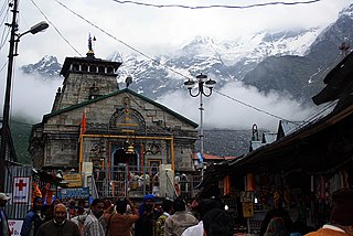
Garhwal is one of the two administrative divisions of the Indian state of Uttarakhand. Lying in the Himalayas, it is bounded on the north by Tibet, on the east by Kumaon, on the south by Uttar Pradesh state, and on the northwest by Himachal Pradesh state. It includes the districts of Chamoli, Dehradun, Haridwar, Pauri Garhwal, Rudraprayag, Tehri Garhwal, and Uttarkashi. The people of Garhwal are known as Garhwali and speak the Garhwali language. The administrative center for Garhwal division is the town of Pauri. The Divisional Commissioner is the administrative head of the Division, and is a senior Indian Administrative Service officer. As the administrative head of the division, the Commissioner is overall incharge of the 7 districts in the Garhwal region of Uttarakhand, and is aided in his duties by an additional commissioner and the district magistrates. Sushil Kumar is the divisional commissioner of the Garhwal Division since December 2021.

<span class="mw-page-title-main">Dehradun</span> Winter capital of Uttarakhand, India

Dehradun, also known as Dehra Doon, is the capital and the most populous city of the Indian state of Uttarakhand. It is the administrative headquarters of the eponymous district and is governed by the Dehradun Municipal Corporation, with the Uttarakhand Legislative Assembly holding its winter sessions in the city as its winter capital. Part of the Garhwal region, and housing the headquarters of its Divisional Commissioner, Dehradun is one of the "Counter Magnets" of the National Capital Region (NCR) being developed as an alternative center of growth to help ease the migration and population explosion in the Delhi metropolitan area and to establish a smart city in the Himalayas.

<span class="mw-page-title-main">Uttarakhand</span> State in northern India

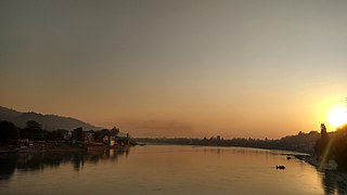
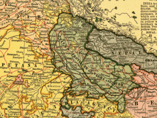
Uttarakhand, formerly known as Uttaranchal, is a state in northern India. The state is bordered by Himachal Pradesh to the northwest, Tibet to the north, Nepal to the east, Uttar Pradesh to the south and southeast, with a small part touching Haryana in the west. Uttarakhand has a total area of 53,566 km2 (20,682 sq mi), equal to 1.6 per cent of the total area of India. Dehradun serves as the state capital, with Nainital being the judicial capital. The state is divided into two divisions, Garhwal and Kumaon, with a total of 13 districts. The forest cover in the state is 45.4 per cent of the state's geographical area. The cultivable area is 16 per cent of the total geographical area. The two major rivers of the state, the Ganges and its tributary Yamuna, originate from the Gangotri and Yamunotri glaciers respectively.

<span class="mw-page-title-main">Khas people</span> Indo-Aryan ethno-linguistic group of Nepal and India

Khas tribe, popularly known as Khashya, according to the 2015 constitution of Nepal are an Indo-Aryan ethno-linguistic group native to the Himalayan region of the Indian subcontinent, in what is now the South Asian country of Nepal, as well as the Indian states of Uttarakhand, Himachal Pradesh,Jammu and Kashmir,West Bengal, Assam and Sikkim. Historically, Khas were the speakers of an ancient Khas language from the Indo-Aryan language family and the earliest recorded speakers of the Western Pahari languages. The large portion of the Indo-Aryan speakers throughout lower Himalayas were the Khas people. An intrusion of this tribe from the Western and Northwestern Himalayas into Central Himalayas is substantiated by the early linguistic evidences related to the Nepali language. They were also known as Parbatiyas/Parbates and are currently known as Paharis/Pahadis.. They were also referred to as Yartse in Tibet and are also known as Khasan by Bhotia people. The term Khas has now become obsolete, as the Khas people have adopted communal identities because of the negative stereotypes associated with the term Khas. In Nepal the native speaker of Nepali language are known as Khas people.

<span class="mw-page-title-main">Tons River</span> River in India

The Tons is the largest tributary of the Yamuna. It flows through Garhwal region in Uttarakhand, touching Himachal Pradesh. The Tons thrust is named after this river.

Chakrata is a cantonment town and also a sub district/tehsil, in Dehradun district in the state of Uttarakhand, India.

<span class="mw-page-title-main">Dehradun district</span> District in Uttarakhand, India

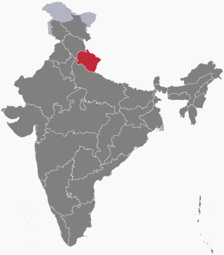
Dehradun district is a district in Garhwal which is a part of Uttarakhand state in northern India. The district headquarters is Dehradun, which has also served as the interim capital of Uttarakhand since its founding in 2000. The district has 6 tehsils, 6 community development blocks, 17 towns and 764 inhabited villages, and 18 unpopulated villages. As of 2011, it is the second most populous district of Uttarakhand, after Haridwar. Dehradun district also includes the prominent towns of Rishikesh, Mussoorie, Landour and Chakrata. The district stretches from the Ganges river in the east to the Yamuna river in the west, and from the Terai and Shivaliks in the south and southeast to the Great Himalaya in the northwest. During the days of British Raj, the official name of the district was Dehra Dun. In 1842, Dun was attached to Saharanpur district and placed under an officer subordinate to the Collector of the district but since 1871 it is being administered as separate district.

<span class="mw-page-title-main">Garhwal District</span>

Garhwal District is a former district in Kumaon of British India of the United Provinces, and had an area of 5,629 sq mi (14,580 km2). It later became a part of the Indian state of Uttar Pradesh, today it is part of the Indian state Uttarakhand.

Herbertpur is a town and a nagar panchayat in Dehradun district Pachhhwadoon in the Indian state of Uttarakhand.

Vikasnagar is a city and a municipality in Dehradun district in the Indian state of Uttarakhand. Vikas Nagar is also a tehsil in Dehradun district

Buraswa is a village which is located 30 km from Chakrata and comes under the Tehsil of Chakrata, Dehradun, Uttarakhand, India.

<span class="mw-page-title-main">History of Uttarakhand</span> State

Uttarakhand is a Himalayan state in North India, nestled between the Tibetan Plateau and the Indo-Gangetic Plains. The name, which means "northern land" or "section" or "northern part" in Sanskrit was made popular in the 80s as part of the wider statehood struggle within the region.

<span class="mw-page-title-main">Mahasu Devta Temple</span> Hindu Temple in Uttarakhand

Italic text'Bold text

<span class="mw-page-title-main">Nati (dance)</span>

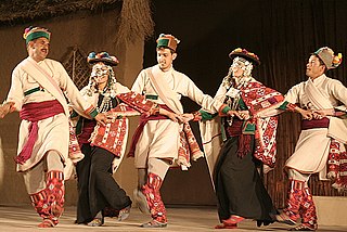
The word Nati is used for the traditional folk dance in the Western and Central Hills of the Indian subcontinent. It is primarily native to the states of Himachal Pradesh and Uttarakhand. Nati is traditionally performed in the Kullu, Mandi, Shimla, Sirmaur, Chamba, Kinnaur, Uttarkashi, Dehradun (Jaunsar-Bawar) and Tehri Garhwal districts. However, due to high immigration of ethnic paharis in the plains, this has been made popular in the plains too. Traditionally, locals dance to the beats of percussion instruments called Dhol-Damau. Pahari dance is listed in the Guinness Book of World Records as largest folk dance.

<span class="mw-page-title-main">Lakhamandal</span> Ancient temple in Uttarakhand, India

Lakhamandal is an ancient Hindu temple complex, situated in the Jaunsar-Bawar region of Dehradun district in the state of Uttarakhand. The temple is dedicated to lord Shiva. This temple is popular among the Shaivites, who believe that a visit to this temple shrine will end their misfortunes.

<span class="mw-page-title-main">Jaunsari people</span> Ethnolinguistic group in Uttarakhand, India

The Jaunsari are a small community found in Uttarakhand, northern India, more specifically in the Jaunsar-Bawar region of the western portion of the state in Garhwal Division. They speak the Jaunsari language which is an Indo-Aryan language.

<span class="mw-page-title-main">Outline of Uttarakhand</span> Overview of and topical guide to Uttarakhand

The following outline is provided as an overview of and topical guide to Uttarakhand:

Kumari Shyama Sharma was an Indian politician and revolutionary. She served as Minister of Law, Panchayati Raj, Food and Civil Supplies (1977–79), Chairperson of Public Accounts Committee (1982-84), Chairperson of Himachal Pradesh Finance Commission (1999), Vice Chairperson of Himachal Planning Board (2000-2003)

<span class="mw-page-title-main">Moila Danda</span> Alpine pasture land in Uttarakhand, India

Moila Danda also known as Moila Top, 'Danda' translates to pasturous fields on higher peaks of the mountains, it's also known as a bugyal. It is situated in the Jaunsar-Bawar region of the Dehradun district of Uttarakhand. Moila Danda is a hiking and camping Destination. The Bugyal has the highest elevation of 2759m and is around 40km from Chakrata. Moila Danda is situated between thousands of Deodar trees. The trek to the Bugyal is of 3km and starts from Budher Forest Rest House, which is around 30km from Chakrata.

Tehsil Tyuni is a tehsil, or administrative division, in the Dehradun district of the Indian state of Uttarakhand. It is located in the northern part of the district and shares its borders with the tehsil Chakrata to south, district Uttarkashi to north and Shimla district of Himachal Pradesh to the west. The tehsil headquarters is located in the town of Tyuni, which is also the largest town in the tehsil. The town is also the largest one in the tribal belt of Jaunsar Bawar.

References

  1. 1 2 3 "The Region". Archived from the original on 2 November 2004. Retrieved 20 May 2008.
  2. 1 2 Jaunsaris
  3. Maroj The Tribune, 15 January 2005.
  4. Dehra Dun District The Imperial Gazetteer of India, 1909, v. 11, p. 213-214.
  5. Chakrata Tahsil & Town The Imperial Gazetteer of India, 1909, v. 10, p. 125.
  6. Agriculture The Imperial Gazetteer of India, 1909, v. 11, p. 215.
  7. Forests The Imperial Gazetteer of India, 1909, v. 24, p. 196.
  8. Jaunsaries www.garhwalhimalayas.com.
  9. Role of Culture in... [ permanent dead link ] ENVIS Bulletin vol 7 no. 1., G.B. Pant Institute of Himalayan Environment and Development, Almora.
  10. Jain, SP; Puri, HS (1984). "Ethnomedicinal plants of Jaunsar-Bawar hills, Uttar Pradesh, India". J Ethnopharmacol. 12 (2): 213–22. doi:10.1016/0378-8741(84)90049-7. PMID   6521494.
  11. Rana, TS; Datt, B. (1997). "Ethnobotanical observation among Jaunsaris of Jaunsar-Bawar, Dehra Dun". International Journal of Pharmacology. 35: 371–374. doi: 10.1080/09251619708951285 .
  12. Department of Sociology, DElhi School of Economics Archived 21 July 2011 at the Wayback Machine Delhi University.
  13. "Jaunsar Bawar #01 | Dance with GODS | Documentary |". YouTube .
  14. Berreman, Gerald D. (1963). "Review: Himalayan Polyandry: Structure, Functioning and Culture Change. A Field-Study of Jaunsar-Bawar". American Anthropologist . 65 (5). Wiley. doi:10.1525/aa.1963.65.5.02a00320. ISSN   1548-1433. JSTOR   668610. From 1932 to 1960, Professor D. N. Majumdar, of Lucknow University worked extensively in this region, along with his student, studying the local tribes.
  15. Cults and Symbology in Jaunsar-Bawar in the Mid Himalayas