
Kumaon is a revenue and administrative division in the Indian State of Uttarakhand. It spans over the eastern half of the state and is bounded on the north by Tibet, on the east by Nepal, on the south by the state of Uttar Pradesh, and on the west by Garhwal. Kumaon comprises six districts of the state: Almora, Bageshwar, Champawat, Nainital, Pithoragarh and Udham Singh Nagar.

Pithoragarh district is the easternmost district in the state of Uttarakhand. It is located in the Himalayas and has an area of 7,110 km2 (2,750 sq mi) and a population of 483,439. The city of Pithoragarh, located in Saur Valley, is its headquarters. The district is within the Kumaon division of Uttarakhand state. The Tibet plateau is situated to the north and Nepal is to the east. The Kali River which originates from the Kalagiri Mountain flows south, forming the eastern border with Nepal. The Hindu pilgrimage route for Mount Kailash-Lake Manasarovar passes through this district via Lipulekh Pass in the greater Himalayas. The district is administratively divided into six Tehsils: Munsyari; Dharchula; Didihat; Berinag; Gangolihat; and Pithoragarh. Naini Saini Airport is the nearest civil airport, but it does not have a regular scheduled commercial passenger service. The mineral deposits present in the district are magnesium ore, copper ore, limestone, and slate. There are 11 tehsils.

Doti District, part of Sudurpashchim Province, is one of the 77 districts of Nepal. This district, with Silgadhi as its headquarters, covers an area of 2,025 square kilometres (782 sq mi) with a population of 207,066 in 2001 and increasing marginally to 211,746 in 2011.

Didihat is a town and a Nagar Palika in Pithoragarh District in the state of Uttarakhand, India. It is one of the eleven administrative subdivisions of Pithoragarh district and also serves as its administrative headquarter. With a population of 6522, Didihat is located at a distance of 415 km (258 mi) from the state capital Dehradun.

The Chand dynasty was a Hindu dynasty that ruled the Kumaon area in present-day Uttarakhand state of India, after the decline of the Katyuri rule. At times, their rule also extended to the western parts of present-day Nepal. Somchand, who claimed Chandravanshi Rajput ancestry, established the dynasty, establishing his capital at Rajbunga in present-day Champawat.

Doti, also known as Dotigarh (डोटीगढ़) or the Far-Western Development Region was a development region of Nepal situated between River Kali bordering Kumaon division of Uttarakhand, India in the west and the Karnali river on the east. Doti was one of eight different princely states of the Katyuri Kingdom.

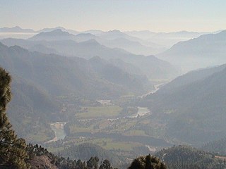
Pithoragarh is a Himalayan town with a Municipal Board in Pithoragarh district in the Indian state of Uttarakhand. It is the largest hill town in Kumaon Division.

Lohaghat is a town and a nagar palika in Champawat district in the Indian state of Uttarakhand. Lohaghat is also famous for its various cultural events like Holi Rang Mahotsav, Devidhar Mela ,etc. Most special thing regarding Lohaghat is the Ramleela of Lohaghat which is one of the oldest Ramleela of Kumaoun Division.
Garkha is the Himalayan fertile and lush green mountain country in front of Askot region of Uttarakhand state of India in the Pithoragarh district. This region tilted from South West to North East. Literally in Kumauni it means the herds of cows. Well linked with roads with Ogla at its entry point. This place lies in the Kanalichhina development block of Didihat tehsil and sub division. This area is lies on the mountain on the northern slopes of western Himalayas. This place is full of Rhododendron, Quercus, Myrica and Pinus forests. In this place many villages lies between Dhanlek peak and Bagarihat and the plains of Titari on the left bank of river Kali on one at lower side. Once ruled by Rajbar of Askot and this place was long under the Gorkha Kings of Nepal. This area was the main area of commerce with river trade point at once flourshing trade city of Bagdihat, on the banks of river Kali.

Baijnath is a small town on the banks of the Gomati river in the Bageshwar district in Kumaon division of Uttarakhand, India. The place is most noted for its ancient temples, which have been recognized as Monuments of National Importance by the Archaeological Survey of India in Uttarakhand. Baijnath has been selected as one of the four places to be connected by the 'Shiva Heritage Circuit' in Kumaon, under the Swadesh Darshan Scheme of the Government of India.
Karki (Devanagari:कार्की) is a Nepali/Kumaoni surname found among the Chhetri community of Nepal and the Kumaoni Rajput community of Uttarakhand.

Gori Ganga is a river in the Munsiari tehsil of the Pithoragarh District, part of the state of Uttarakhand in northern India. Its principal source is the Milam Glacier, just northeast of Nanda Devi along with the Glaciers of the Ralam River, and the Pyunshani and Uttari & Dakshini Balati Glaciers that lie on the western face of the Panchachuli Peaks.
The Katyuri kings were a medieval Hindu ruling clan of Khasha origin that ruled over the regions in Uttarakhand in India and western Nepal from 700 to 1200 CE. The founder of this dynasty, King Vasu Dev was originally a Buddhist ruler, but later he started following Hindu practices sometimes attributed to a vigorous campaign of Hindu philosopher Adi Shankara.

Johar Valley is a valley located in Pithoragarh district of Uttarakhand, India, along the Gori Ganga river. The valley used to be a major trade route with Tibet. The best known villages in the valley are Martoli and Milam.

The Far-Western Development Region was one of Nepal's five development regions. It was located at the western end of the country and had its headquarters in Dipayal.
Dethala is a village development committee in Darchula District in the Mahakali Zone of western Nepal. At the time of the 1991 Nepal census it had a population of 3155 people living in 507 individual households.

Kumaon Kingdom was an independent Himalayan kingdom in Kumaon, a region located in the eastern part of the present-day Uttarakhand state of India. It was established around 7th century and remained an independent and sovereign kingdom until 1791.
Historically, the "Thakuri" is one of influential tribe in Nepal that held significant history in Nepal, forming the core of the country's ruling class.
Kumaoni Rajput, also referred to as Thakur, Rajput or Kshetri is a small community of Rajputs who wielded considerable power in the Kumaon region, from around the 4th century till the conquest of Kumaon by the Gorkha.
Rajwar was a title used by the Katyuri Kings and Chand Rajput community of Kumaon.


