Thal, Uttarakhand

Last updated
Thal
town
Thal4.jpg
Ek Hathiya Dewal Temple at Thal
India Uttarakhand location map.svg
Red pog.svg
Thal
Location in Uttarakhand, India
India location map.svg
Red pog.svg
Thal
Thal (India)
Coordinates: 29°49′35″N80°08′27″E / 29.8265°N 80.1408°E / 29.8265; 80.1408
CountryFlag of India.svg  India
State Uttarakhand
District Pithoragarh
Population
  Total5,000 (estimated) [1]
Languages
  Official Hindi
Time zone UTC+5:30 (IST)
Vehicle registration UK 05

Thal is a small town situated on the banks of Ramganga river in the Pithoragarh district in the Indian state of Uttarakhand. It is one of the thirteen tehsils of district Pithoragarh. [2]

Contents

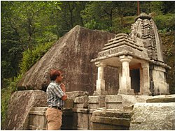
Thal has been a centre for local trade for nearby settlements at Didihat, Munsiari, Chaukori and Dharamghar since antiquity. It is also known for a 9th century Shiva temple located on the bank of Ramganga river and the Ek Hathiya Dewal temple - a rock cut temple believed to be crafted by a one-armed artisan.

Thal was a block of the Almora district from 1957 to 1962. Since 30 September 2014, it is a tehsil of the Pithoragarh district, which was constituted from 114 villages earlier part of Berinag and Didihat tehsil.

History

Thal is among the oldest towns in Pithoragarh district. It has been a centre for local trade for nearby settlements at Didihat, Munsiari, Chaukori and Dharamghar since antiquity. [3] There is a 9th century Shiva temple located on the bank of Ramganga river, which was built under the patronage of Katyuri kings. [3] Baleshwar form of Lord Shiva is worshiped in this temple. At the time of Bikhaut Sankranti, an 8-day fair used to be held here, which amassed a gathering of around 15,000 people in 1911. [4]

Thal was connected by a motor road with Almora in 1955 and in 1957, the then UP government opened a Community development block office in Thal. [5] There were 600 villages under this development block. The development block continued functioning till 1962, after which the government closed this development block office and divided the villages falling in Thal development block into Didihat and Berinag development blocks. [5] In 1962, a 68 meter long bridge was built over the Ramganga river at Thal. [6] A primary health center was opened here on 11 October 2000. [7]

Administration

Thal is among one of the thirteen tehsils of the Pithoragarh district. The notification for formation of tehsil in Thal was issued on 30 September 2014, but the tehsil started functioning almost a year later from 13 September 2015. 114 villages of several Patwari areas of Berinag and Didihat tehsil were reorganised to form the Thal tehsil. [8]

Economy

The Thal fair used to be frequented by the Bhotiya traders, who used to sell utensils and wool for the last time before returning to Tibet. [9] Apart from this, clothes from Kashipur and Almora and oil and chilli products from Sor and Sira were also bought and sold. A market was sanctioned under the scheme of Mandi Parishad in Thal to facilitate the local producers of vegetables, fruits and grains from Thal, Didihat, Munsiyari and Berinag. [10]

Transport

Thal was connected by a motor road with Almora in 1955, which connected Almora with Munsiari via Bageshwar, Udiyari and Thal. [11]

Education

Haridutt Pant Government Inter College is situated at Thal. In 2017, 350 students were studying here. [12]

Related Research Articles

Gairsain is a town in Chamoli district of the Indian state of Uttarakhand near state's summer capital Bhararisain. A town and Nagar Panchayat, Gairsain is situated at the eastern edge of the vast Dudhatoli mountain range, and is located in Chamoli district almost at the centre of the state, at a distance of approximately 250 kilometres from Dehradun. It is easily accessible from both the Garhwal and the Kumaon divisions, and in a way, acts as the bridge between the two regions. It is being considered as the future Permanent capital of Uttarakhand.

<span class="mw-page-title-main">Pithoragarh district</span> District of Uttarakhand in India

Pithoragarh district is the easternmost district in the state of Uttarakhand. It is located in the Himalayas and has an area of 7,110 km2 (2,750 sq mi) and a population of 483,439. The city of Pithoragarh, located in Saur Valley, is its headquarters. The district is within the Kumaon division of Uttarakhand state. The Tibet plateau is situated to the north and Nepal is to the east. The Kali River which originates from the Kalagiri Mountain flows south, forming the eastern border with Nepal. The Hindu pilgrimage route for Mount Kailash-Lake Manasarovar passes through this district via Lipulekh Pass in the greater Himalayas. The district is administratively divided into six Tehsils: Munsyari; Dharchula; Didihat; Berinag; Gangolihat; and Pithoragarh. Naini Saini Airport is the nearest civil airport, but it does not have a regular scheduled commercial passenger service. The mineral deposits present in the district are magnesium ore, copper ore, limestone, and slate. There are 11 tehsils.

<span class="mw-page-title-main">Didihat</span> Town in Uttarakhand, India

Didihat is a town and a Nagar Palika in Pithoragarh District in the state of Uttarakhand, India. It is one of the eleven administrative subdivisions of Pithoragarh district and also serves as its administrative headquarter. With a population of 6522, Didihat is located at a distance of 415 km (258 mi) from the state capital Dehradun.

<span class="mw-page-title-main">Bageshwar</span> Town in Uttarakhand, India

Bageshwar is a town and a municipal board in Bageshwar district in the state of Uttarakhand, India. It is located at a distance of 470 km from the National Capital New Delhi and 332 km from the State Capital Dehradun. Bageshwar is known for its scenic environment, glaciers, rivers and temples. It is also the administrative headquarters of Bageshwar district.

<span class="mw-page-title-main">Berinag</span> Hill Station in Uttarakhand, India

Berinag is a hill station, located 124 km from Pithoragarh city in the Pithoragarh district, which is the easternmost Himalayan district in the state of Uttarakhand, India. It is one of the six Administrative Subdivisions (tehsil) of Pithoragarh district. National Highway 309A passes through Berinag. Closest prominent villages include Garawon, Dhanoli, Bana, Bhattigaon, Banoli, Quarali, Tripuradevi and Sangarh.

<span class="mw-page-title-main">Chaukori</span> Village in Uttarakhand, India

Chaukori is a hill station in the Pithoragarh district set among the lofty peaks of the western Himalayan Range in the Kumaon Division of Uttarakhand, India. To its north is Tibet and to its south is Terai. The Mahakali River, running along its eastern boundary, forms the Indo-Nepal international border. This place has become a prominent tourist place and from here a wide and picturesque view of Himalayan range can be viewed. The golden yellow colour of sun rays falling on the Himalayan range in the morning time is really worth seeing. There are cottages available here where one can stay and enjoy the serene surroundings. Tourists coming to this place generally also visit the nearby tourist places like Patal Bhuvaneshwar, Kausani, Bageshwar and Almora.

Devalthal is a tehsil of Pithoragarh District in Uttarakhand state, in northern India. It has an estimated population of 12,000, and has a treasury, bank, post office, government, private school, rest house.

<span class="mw-page-title-main">Chaukhutia</span> Town in Uttarakhand, India

Chaukhutia is a town in Almora district of Uttarakhand. It is located on the bank of the river Ramganga, and derives its name from a Kumaoni word "Chau-khut" which means four feet. In Chaukhutia's context, 'four feet' means four ways or directions. The first way is towards Ramnagar, second towards Karanprayag, third towards Ranikhet and Almora and the fourth way is towards Tadagtaal, Kheera.

Reetika Khera is an Indian development economist. Khera is Professor (Economics) at the Indian Institute of Technology, Delhi. She was Associate Professor at the Indian Institute of Management, Ahmedabad from 2018-20.

<span class="mw-page-title-main">Kanda, Uttarakhand</span> Town in Uttarakhand, India

Kanda is a small historic town and tehsil in Bageshwar district, in the state of Uttarakhand, India.

<span class="mw-page-title-main">Bagnath Temple</span> Hindu Temple in Uttarakhand

Bagnath Temple is an ancient shrine dedicated to Shiva, situated in the Bageshwar city at the confluence of Sarayu and Gomati rivers. Bagnath Temple is festooned with bells of all sizes and features impressive carvings. It is the most famous Temple in Bageshwar District. It is flooded with devotees on the occasion of Shivratri. The city of Bageshwar gets its name from this Temple.

<span class="mw-page-title-main">National Highway 309A (India)</span> National highway in India

National Highway 309A, commonly referred to as NH 309A, is a single lane highway connecting the city of Rameshwar to Almora in the Indian State of Uttarakhand. Before the creation of Uttarakhand state in 2000, the Almora-Bageshwar stretch of this Highway was a part of the State Highway 37 of Uttar Pradesh, which ran from Bageshwar to Bareilly.

<span class="mw-page-title-main">Vijaypur, Uttarakhand</span> Hill Station in Uttarakhand, India

Vijaypur, officially known as Bijaypur is a hill station and village situated in Bageshwar district in the state of Uttarakhand, India. It is located at a distance of 30 km from Bageshwar and 5 km from Kanda; amidst dense Pine Forests on the Bageshwar-Chaukori Highway.

The Coolie-Begar or Coolie- Utar movement was a non-violent movement by the general public of Kumaun in the Bageshwar town of United Provinces in 1921. This movement was led by Hargovind Pant and Badri Datt Pandey, who were awarded the titles of 'Jannayak' and 'Kumaon Kesari' respectively after the success of this movement. The aim of this movement was to put pressure on the British to end the practice of Coolie-Begar. Mahatma Gandhi, while praising the movement, named it 'Bloodless Revolution'.

<span class="mw-page-title-main">Kala Chauna</span> Village

Kala Chauna is a village of Talla Gewar. It is located in Chaukhutiya block of Almora district in the Indian state of Uttarakhand.

<span class="mw-page-title-main">Indira Gandhi International Sports Stadium</span> Stadium in Haldwani, Uttarakhand, India

Indira Gandhi International Sports Stadium is located in Haldwani, Uttarakhand, India. It can seat 25,000 spectators and was inaugurated on 18 December 2016 by Harish Rawat, the then Chief Minister of Uttarakhand. It is spread over 70 acres and has cricket and football grounds, a track for 800-metre race, a hockey field, badminton courts, a lawn tennis court, a boxing ring, and a swimming pool.

Uttarakhand Day also referred to as Uttarakhand Divas, is celebrated as the state foundation day of Indian state Uttarakhand. It is observed annually on 9 November.

<span class="mw-page-title-main">Manoj Tiwari (Uttarakhand politician)</span> Indian politician

Manoj Tewari is an Indian politician from Almora, Uttarakhand and a three term Member of the Uttarakhand Legislative Assembly. Manoj represented the Almora Assembly constituency in the 2nd & 3rd Uttarakhand legislative Assembly and 2022 Uttarakhand Legislative Assembly election.

<span class="mw-page-title-main">Mordhwaj</span> King in Indian folklore

According to Indian folklore, Mordhwaj or Mordhwaja or Murddhawaja is an ancient king of the Mahabharata period, who is believed to have been blessed by Krishna.

References

  1. "दो विधायक चुनते हैं थल कस्बे के लोग". Amar Ujala (in Hindi). Archived from the original on 14 June 2018. Retrieved 14 June 2018.
  2. "Tehsil | District Pithoragarh, Government of Uttarakhand | India" . Retrieved 17 April 2024.
  3. 1 2 Menon, Srikumar M.; G., Sudhakara (2020). "Ek Hathiya Dewal: A Rock-Cut Nagara Temple at Thal, Uttarakhand" (PDF). Heritage: Journal of Multidisciplinary Studies in Archaeology. 8 (2): 34–55. Retrieved 17 April 2024.
  4. Walton, H. G. (1911). Almora: A Gazetter. Allahabad: The Government Press, United Provinces. p. 296.
  5. 1 2 "थल ब्लॉक का अस्तित्व 55 वर्ष पहले समाप्त हो गया". Amar Ujala (in Hindi). Archived from the original on 25 October 2017. Retrieved 24 October 2017.
  6. "थल के मोटर पुल की हालत खराब". Amar Ujala (in Hindi). Archived from the original on 25 October 2017. Retrieved 24 October 2017.
  7. "अस्पताल में 17 वर्ष बाद भी सुविधाओं का अभाव". Amar Ujala (in Hindi). Archived from the original on 25 October 2017. Retrieved 24 October 2017.
  8. "इस तहसील से अब तक लोगों को कोई फायदा नहीं". Amar Ujala (in Hindi). Archived from the original on 25 October 2017. Retrieved 24 October 2017.
  9. Shah, Giriraj (1975). The Kingdom of Gods, Uttarakhand. Abhinav Publications. ISBN   978-0-88386-724-2 . Retrieved 18 April 2024.
  10. "दो करोड़ की मंडी बनी आवारा जानवरों की आरामगाह -". Jagran (in Hindi). Archived from the original on 24 October 2017. Retrieved 24 October 2017.
  11. Kapadia, Harish (1999). Across Peaks & Passes in Kumaun Himalaya. New Delhi: Indus Publishing. ISBN   978-81-7387-096-5 . Retrieved 18 April 2024.
  12. "100 विद्यार्थियों ने जीआईसी थल से नाम कटाया". Amar Ujala (in Hindi). Archived from the original on 25 October 2017. Retrieved 24 October 2017.