
Manali is a town, near Kullu town in Kullu district in the Indian state of Himachal Pradesh. It is situated in the northern end of the Kullu Valley, formed by the Beas River. The town is located in the Kullu district, approximately 270 kilometres (170 mi) north of the state capital of Shimla and 544 kilometres (338 mi) northeast of the national capital of New Delhi. With a population of 8,096 people recorded in the 2011 Indian census Manali is the beginning of an ancient trade route through Lahaul (H.P) and Ladakh, over the Karakoram Pass and onto Yarkand and Hotan in the Tarim Basin of China. Manali is a popular tourist destination in India and serves as the gateway to the Lahaul and Spiti district as well as the city of Leh in Ladakh.
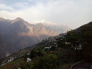
Joshimath, also known as Jyotirmath, is a town and a municipal board in Chamoli District in the Indian state of Uttarakhand. Located at a height of 6,150 feet, it is a gateway to several Himalayan mountain climbing expeditions, trekking trails and pilgrim centres like Badrinath. It is home to one of the four cardinal pīthas established by Adi Shankara.

Champawat is a town and a Nagar Palika Parishad in Champawat district in the state of Uttarakhand, India. It is the administrative headquarters of Champawat district. The town was the former capital of the Kumaon Kingdom.
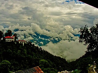
Mussoorie is a hill station and a municipal board, near Dehradun city in the Dehradun district of the Indian state Uttarakhand. It is about 35 kilometres (22 mi) from the state capital of Dehradun and 290 km (180 mi) north of the national capital of New Delhi. The hill station is in the foothills of the Garhwal Himalayan range. The adjoining town of Landour, which includes a military cantonment, is considered part of "greater Mussoorie", as are the townships Barlowganj and Jharipani.
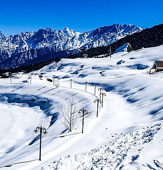
Auli is in Chamoli district in the Himalayan mountains of Uttarakhand, India. Auli, also known as Auli Bugyal, in Garhwali, which means "meadow", is located at an elevation of 2,800 metres (9,200 ft) above sea level. Between June and October, the valley has one of highest numbers of flower species found anywhere in the world, with 520 species of high altitude plants, 498 of which are flowering plants with significant populations of endangered species.

Devprayag is a town and a nagar panchayat, near New Tehri city in Tehri Garhwal District in the state of Uttarakhand, India, and is the final one of the Panch Prayag of Alaknanda River where Alaknanda meets the Bhagirathi river and both rivers thereafter flow on as the Ganges river or Ganga.

Didihat is a town and a Nagar Palika in Pithoragarh District in the state of Uttarakhand, India. It is one of the eleven administrative subdivisions of Pithoragarh district and also serves as its administrative headquarter. With a population of 6522, Didihat is located at a distance of 415 km (258 mi) from the state capital Dehradun.
Pauri Garhwal is a district in the Indian state of Uttarakhand. Its headquarters is in the town of Pauri. It is sometimes referred to simply as Garhwal district, though it should not be confused with the larger Garhwal region of which it is only a part of.

Karnaprayag is a town and municipal board in the Chamoli District in the Indian state of Uttarakhand. Karnaprayag is one of the Panch Prayag of Alaknanda River, situated at the confluence of the Alaknanda and Pindar River.

Ramnagar is a town and municipal board in the Nainital district of Kumaon, India. It is located approximately 65 kilometres (40 mi) from Nainital, the headquarters of the district.
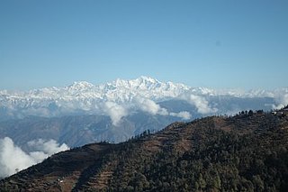
Kausani is a hill station and Village situated in Bageshwar district in the state of Uttarakhand, India. It is famous for its scenic splendour and its spectacular 300 km-wide panoramic view of Himalayan peaks like Trisul, Nanda Devi and Panchchuli. Mahatma Gandhi called this place the 'Switzerland of India', due to similarity in landscapes.
Dunagiri is a historic area in Almora district in the state of Uttarakhand in India. Dunagiri is known as the birthplace of modern-day Kriya Yoga due to the fact that Lahiri Mahasaya was initiated into Kriya Yoga by Mahavatar Babaji at this site.
Dhanaulti is a quiet hill station at an elevation of 2286 meters above sea level, it offers panoramic views of the lofty Himalayas.

Borasu Pass or Bara-su is a high mountain pass in the Himalaya Mountains of Uttarakhand in the India. The pass is located on the border of Uttarakhand and Himachal Pradesh near the border with Tibet. It was an ancient trade route between Har Ki Doon valley and Kinnaur valley.
Pantnagar Airport is a domestic airport serving Pantnagar and its adjoining regions, located in the Udham Singh Nagar district in of Uttarakhand, India. It is operated by the Airports Authority of India. It is the nearest airport to the Kumaon division and is located in the middle of Haldwani and Rudrapur, the two largest cities of Kumaon. It is 26 km from Haldwani and from the Kumaon hill stations of Nainital (65 km), Bhimtal (50 km), Ranikhet (110 km) and Almora (120 km), Bareilly (65 km) and the Jim Corbett National Park (120 km).

Panch Kedar refers to five Hindu temples or holy places of the Shivaite sect dedicated to god Shiva. They are located in the Garhwal Himalayan region in Uttarakhand, India. They are the subject of many legends that directly link their creation to Pandavas, the heroes of the Hindu epic Mahabharata.
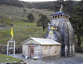
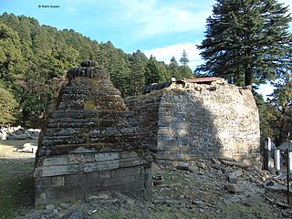
Madhyamaheshwar or Madmaheshwar is a Hindu temple dedicated to Shiva, located in Gaundar, a village in the Garhwal Himalayas of Uttarakhand, India. Situated at an elevation of 3,497 m (11,473.1 ft), it is one of the Panch Kedar pilgrimage circuits, comprising five Shiva temples in the Garhwal region. The other temples in the circuit include: Kedarnath, Tungnath and Rudranath which are culturally visited before Madhyamaheshwar and, Kalpeshwar generally visited after Madhyamaheshwar. The middle (madhya) or belly part or navel (nabhi) of Shiva is worshipped here. The temple is believed to have been built by the Pandavas, the central figures of the Hindu epic Mahabharata.
Kanatal is a small village that is a hill station in the state of Uttarakhand, India. Kanatal is 78 km from Dehradun, 38 km from Mussoorie and 12 km from Chamba. It is on the Chamba-Mussoorie road and nearly 300 km from Delhi.
Govind Pashu Vihar National Park and Wildlife Sanctuary is a national park in Supin Range, near Uttarkashi town of Uttarkashi district in Uttarakhand, India established initially as a wildlife sanctuary in 1955, and was later converted into a national park. It is named after a prominent Indian freedom fighter and politician Govind Ballabh Pant, who became Home Minister in 1955 and is remembered for his achievement in establishing Hindi as an official language of India.
Chanderkhani Pass is a pass located in the Kullu District of India at a height of 3,660 metres. It forms a way (pass) between the villages of Rumsu and Pulag to the well known village of Malana, which indirectly forms a trekking route from Naggar to Malana across the Chanderkhani Pass.

