Chaukori

Last updated

Chaukori
Village
Himalayan range Chaokori.jpg
Chaukori
India Uttarakhand location map.svg
Red pog.svg
Chaukori
Location in Uttarakhand, India
India location map.svg
Red pog.svg
Chaukori
Chaukori (India)
Coordinates: 29°50′28″N80°01′50″E / 29.84124°N 80.030594°E / 29.84124; 80.030594
CountryFlag of India.svg  India
State Uttarakhand
Division Kumaon
District Pithoragarh
Area
[1]
  Total8.3618 km2 (3.2285 sq mi)
Elevation
2,010 m (6,590 ft)
Population
 (2011) [2]
  Total1,163
  Density140/km2 (360/sq mi)
Languages
  Official Hindi
Sanskrit
Time zone UTC+5:30 (IST)
Vehicle registration UK 05
Website uk.gov.in

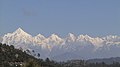
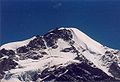
Chaukori is a hill station in the Pithoragarh district set among the lofty peaks of the western Himalayan Range in the Kumaon Division of Uttarakhand, India. To its north is Tibet and to its south is Terai. The Mahakali River, running along its eastern boundary, forms the Indo-Nepal international border. This place has become a prominent tourist place and from here a wide and picturesque view of Himalayan range can be viewed. The golden yellow colour of sun rays falling on the Himalayan range in the morning time is really worth seeing. There are cottages available here where one can stay and enjoy the serene surroundings. Tourists coming to this place generally also visit the nearby tourist places like Patal Bhuvaneshwar, Kausani, Bageshwar and Almora.

Contents

Geography

Chaukori is located in Berinag Tehsil of Pithoragarh district in Uttarakhand, India. [3] It is situated 10km away from sub-district headquarter Berinag [4] and 86km away from district headquarter Pithoragarh. [1] Chaukori's elevation is 2010 m with spectacular panoramic views of the snowy peaks of Nanda Devi, Nanda Kot and the Panchchuli group.

Demographics

Chaukori is a medium size village located in Berinag of Pithoragarh district, Uttarakhand with total 248 families residing. Total population of Chaukori is 1163 out of which 672 are males while 491 are females as per Population Census 2011. [3] [5] In Chaukori, population of children with age 0-6 is 190 which makes up 16.34 % of total population. [3] Average Sex Ratio of Chaukori is 731 [5] which is lower than Uttarakhand state average of 963. [3] Child Sex Ratio for Chaukori as per census is 624, [5] lower than Uttarakhand average of 890. [3] Chaukori has lower literacy rate as compared to Uttarakhand. In 2011, literacy rate of Chaukori was 76.36 % [5] compared to 78.82 % of Uttarakhand. [3] In Chaukori, Male literacy stands at 87.03 % while female literacy rate was 62.20 %. [3] In Chaukori, most of the villagers are from Schedule Caste (SC). Schedule Caste (SC) constitutes 38.95 % [5] while Schedule Tribe (ST) were 0.77 % of total population in Chaukori. [3] In Chaukori, out of total population, 354 were engaged in work activities. [3] 74.58 % of workers describe their work as Main Work (Employment or Earning more than 6 Months) while 25.42 % were involved in Marginal activity providing livelihood for less than 6 months. [3] Of 354 workers engaged in Main Work, 45 were cultivators (owner or co-owner) while 1 were Agricultural labourer. [3] As per constitution of India and Panchyati Raaj Act, Chaukori is administrated by a Sarpanch who is an elected representative of the village. [3]

Temples

Gangolihat, 35 km away, is an important religious centre with the Hat-Kalika temple. Also in the general area are the following temples: [6]

Transport

Chaukori is well connected with Motorable roads to major destinations in Kumaon. The Udiari Bend in Chaukori marks the intersection of roads coming from Kanda-Bageshwar, Seraghat-Almora and Thal-Munsiari. Seraghat is a tri-junction which is connecting to Naini through separate road via Dhankhet, Salla Bhatkot, Nali, Kunj Kimola etc village panchayat. Shared Taxis, locally called Jeeps are the mostly preferred for short distance Transport. Jeeps ply from Chaukori to the nearby towns of Berinag, Kanda and Thal. Buses are mostly used for Interstate Transport. Bus services are provided by the state owned 'Uttarakhand Transport Corporation' and the privately owned 'K.M.O.U bus Services'. Buses connect Chaukori with the cities of Bageshwar, Pithoragarh, Almora, Dharchula and Delhi. Distance from other cities and towns are listed below. [7]

The closest railhead is 198 km at Kathgodam.

Panoramic view of the Himalayas, from Chaukori Chaukori.jpg
Panoramic view of the Himalayas, from Chaukori

Reference notes

  1. 1 2 "Chaukori - Indian Village Directory" . Retrieved 3 October 2016.
  2. DCHB Pithoragarh Part-A (PDF). Retrieved 3 October 2016.
  3. 1 2 3 4 5 6 7 8 9 10 11 12 "Chaukori Population - Berinag - Pithoragarh, Uttarakhand". www.census2011.co.in. Retrieved 3 October 2016.
  4. "Chaukori: Holiday Haven". Indiatravelogue. Retrieved 18 October 2006.
  5. 1 2 3 4 5 District Census Handbook - Pithoragarh, Part-B (PDF). Retrieved 3 October 2016.
  6. "Temples". pithoragarh,nic.in. Archived from the original on 7 November 2006. Retrieved 18 October 2006.
  7. "Chaukori". india.journeymart.com. Retrieved 18 October 2006.


Related Research Articles

<span class="mw-page-title-main">Kumaon division</span> Administrative division in India

Kumaon is a revenue and administrative division in the Indian State of Uttarakhand. It spans over the eastern half of the state and is bounded on the north by Tibet, on the east by Nepal, on the south by the state of Uttar Pradesh, and on the west by Garhwal. Kumaon comprises six districts of the state: Almora, Bageshwar, Champawat, Nainital, Pithoragarh and Udham Singh Nagar.

<span class="mw-page-title-main">Almora district</span> District of Uttarakhand in India

Almora is a district in the Kumaon Division of Uttarakhand state, India. The headquarters is at Almora. It is 1,638 meters above sea level. The neighbouring regions are Pithoragarh district to the east, Chamoli district to the west, Bageshwar district to the north and Nainital district to the south.

<span class="mw-page-title-main">Pithoragarh district</span> District of Uttarakhand in India

Pithoragarh district is the easternmost district in the state of Uttarakhand. It is located in the Himalayas and has an area of 7,110 km2 (2,750 sq mi) and a population of 483,439. The city of Pithoragarh, located in Saur Valley, is its headquarters. The district is within the Kumaon division of Uttarakhand state. The Tibet plateau is situated to the north and Nepal is to the east. The Kali River which originates from the Kalagiri Mountain flows south, forming the eastern border with Nepal. The Hindu pilgrimage route for Mount Kailash-Lake Manasarovar passes through this district via Lipulekh Pass in the greater Himalayas. The district is administratively divided into six Tehsils: Munsyari; Dharchula; Didihat; Berinag; Gangolihat; and Pithoragarh. Naini Saini Airport is the nearest civil airport, but it does not have a regular scheduled commercial passenger service. The mineral deposits present in the district are magnesium ore, copper ore, limestone, and slate. There are 11 tehsils.

<span class="mw-page-title-main">Didihat</span> Town in Uttarakhand, India

Didihat is a town and a Nagar Palika in Pithoragarh District in the state of Uttarakhand, India. It is one of the eleven administrative subdivisions of Pithoragarh district and also serves as its administrative headquarter. With a population of 6522, Didihat is located at a distance of 415 km (258 mi) from the state capital Dehradun.

Namik Glacier is situated in the Pithoragarh district of Uttarakhand state in India.

<span class="mw-page-title-main">Traill's Pass</span> Mountain pass through the Himalayas

Pindari Kanda Traill's Pass is a mountain pass through the Himalayas located between Nanda Devi and Nanda Kot peaks in the Uttarakhand state in the districts of Pithoragarh and Bageshwar in India.

<span class="mw-page-title-main">Bageshwar district</span> District of Uttarakhand in India

Bageshwar is a district of Uttarakhand state in northern India. The town of Bageshwar is the district headquarters. Prior to its establishment as a district in 1997 it was part of Almora district.

<span class="mw-page-title-main">Bageshwar</span> Town in Uttarakhand, India

Bageshwar is a town and a municipal board in Bageshwar district in the state of Uttarakhand, India. It is located at a distance of 470 km from the National Capital New Delhi and 332 km from the State Capital Dehradun. Bageshwar is known for its scenic environment, glaciers, rivers and temples. It is also the administrative headquarters of Bageshwar district.

<span class="mw-page-title-main">Almora</span> Town in Uttarakhand, India

Almora is a municipal board and a cantonment town in the state of Uttarakhand, India. It is the administrative headquarters of Almora district. Almora is located on a ridge at the southern edge of the Kumaon Hills of the Himalaya range. The Koshi (Kaushiki) and Suyal (Salmale) rivers flow along the city and snow-capped Himalayas can be seen in the background.

<span class="mw-page-title-main">Berinag</span> Hill Station in Uttarakhand, India

Berinag is a hill station, located 124 km from Pithoragarh city in the Pithoragarh district, which is the easternmost Himalayan district in the state of Uttarakhand, India. It is one of the six Administrative Subdivisions (tehsil) of Pithoragarh district. National Highway 309A passes through Berinag. Closest prominent villages include Garawon, Dhanoli, Bana, Bhattigaon, Banoli, Quarali, Tripuradevi and Sangarh.

<span class="mw-page-title-main">Kausani</span> Hill Station in Uttarakhand, India

Kausani is a hill station and Village situated in Bageshwar district in the state of Uttarakhand, India. It is famous for its scenic splendour and its spectacular 300 km-wide panoramic view of Himalayan peaks like Trisul, Nanda Devi and Panchchuli. Mahatma Gandhi called this place the 'Switzerland of India', due to similarity in landscapes.

<span class="mw-page-title-main">Garur</span> Town in Uttarakhand

Garur is a town in the Bageshwar district of the state of Uttarakhand, India.

<span class="mw-page-title-main">Baijnath, Uttarakhand</span> Town in Uttarakhand, India

Baijnath is a small town on the banks of the Gomati river in the Bageshwar district in Kumaon division of Uttarakhand, India. The place is most noted for its ancient temples, which have been recognized as Monuments of National Importance by the Archaeological Survey of India in Uttarakhand. Baijnath has been selected as one of the four places to be connected by the 'Shiva Heritage Circuit' in Kumaon, under the Swadesh Darshan Scheme of the Government of India.

<span class="mw-page-title-main">Kanda, Uttarakhand</span> Town in Uttarakhand, India

Kanda is a small historic town and tehsil in Bageshwar district, in the state of Uttarakhand, India.

<span class="mw-page-title-main">Outline of Uttarakhand</span> Overview of and topical guide to Uttarakhand

The following outline is provided as an overview of and topical guide to Uttarakhand:

Sani Udiyar is a village situated in Kanda Tehsil in Bageshwar district in the State of Uttarakhand, India. It is located at a distance of 15 kilometres (9.3 mi) from Kanda and 36 kilometres (22 mi) from Bageshwar. Sani Udiyar is a medium-sized village with total 88 families residing. It has substantial population of people belonging to Schedule Caste.

<span class="mw-page-title-main">National Highway 309A (India)</span> National highway in India

National Highway 309A, commonly referred to as NH 309A, is a single lane highway connecting the city of Rameshwar to Almora in the Indian State of Uttarakhand. Before the creation of Uttarakhand state in 2000, the Almora-Bageshwar stretch of this Highway was a part of the State Highway 37 of Uttar Pradesh, which ran from Bageshwar to Bareilly.

<span class="mw-page-title-main">Sarju</span> River in Uttarakhand, India

The Sarju, also known as Sarayu, is a major river draining Central Kumaon region in the Indian state of Uttarakhand. Originating from Sarmul, Sarju flows through the cities of Kapkot, Bageshwar and Seraghat before joining Mahakali at Pancheshwar. The Sarju is the largest tributary of the Sharda River. The river forms the South-eastern border between the districts of Pithoragarh and Almora. Temperate and sub-Tropical forests cover the entire Catchment area of the River.

Mankot is a Village situated in Bageshwar district in the State of Uttarakhand, India. It is located at a distance of 13.5 kilometres (8.4 mi) from Bageshwar on the National Highway 309A. Mankot is a medium-sized village with total 118 families residing.

<span class="mw-page-title-main">Vijaypur, Uttarakhand</span> Hill Station in Uttarakhand, India

Vijaypur, officially known as Bijaypur is a hill station and village situated in Bageshwar district in the state of Uttarakhand, India. It is located at a distance of 30 km from Bageshwar and 5 km from Kanda; amidst dense Pine Forests on the Bageshwar-Chaukori Highway.